Self-evolution ANFIS and UKF combined GPS/MEMS-INS integrated positioning error dynamic forecasting method

A technology of error dynamics and prediction methods, applied in satellite radio beacon positioning systems, measuring devices, surveying and mapping and navigation, etc., can solve problems such as large prediction errors, achieve real-time performance, improve dynamic applicability and self-adaptive capabilities Effect

Inactive Publication Date: 2010-09-01
BEIHANG UNIV
View PDF4 Cites 44 Cited by
  • Summary
  • Abstract
  • Description
  • Claims
  • Application Information

AI Technical Summary

Problems solved by technology

The combination of fading adaptive Kalman filter and gradient descent algorithm realizes the self-evolution real-time update of ANFIS model parameters, which ensures the real-time performance of the navigation system, and can solve the problem of large prediction error when the carrier is dynamic, and enhances the The dynamic performance and adaptive abil

Method used


Image

  • Self-evolution ANFIS and UKF combined GPS/MEMS-INS integrated positioning error dynamic forecasting method
  • Self-evolution ANFIS and UKF combined GPS/MEMS-INS integrated positioning error dynamic forecasting method
  • Self-evolution ANFIS and UKF combined GPS/MEMS-INS integrated positioning error dynamic forecasting method

Examples


Embodiment Construction

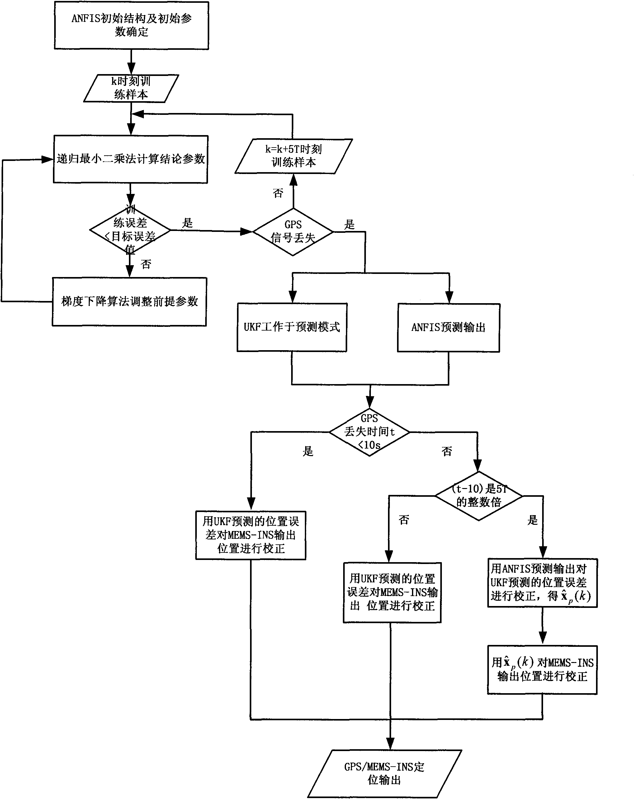
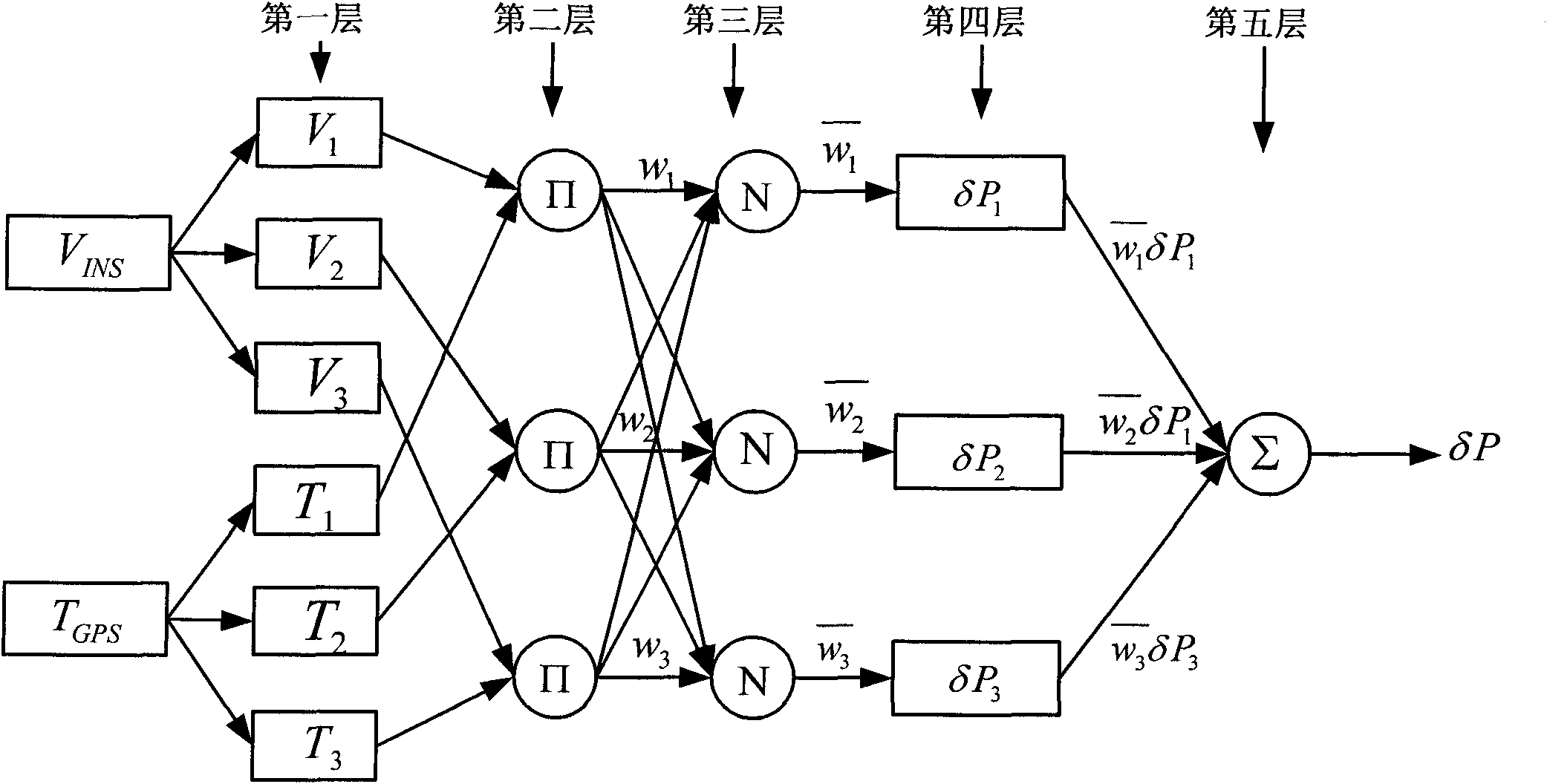
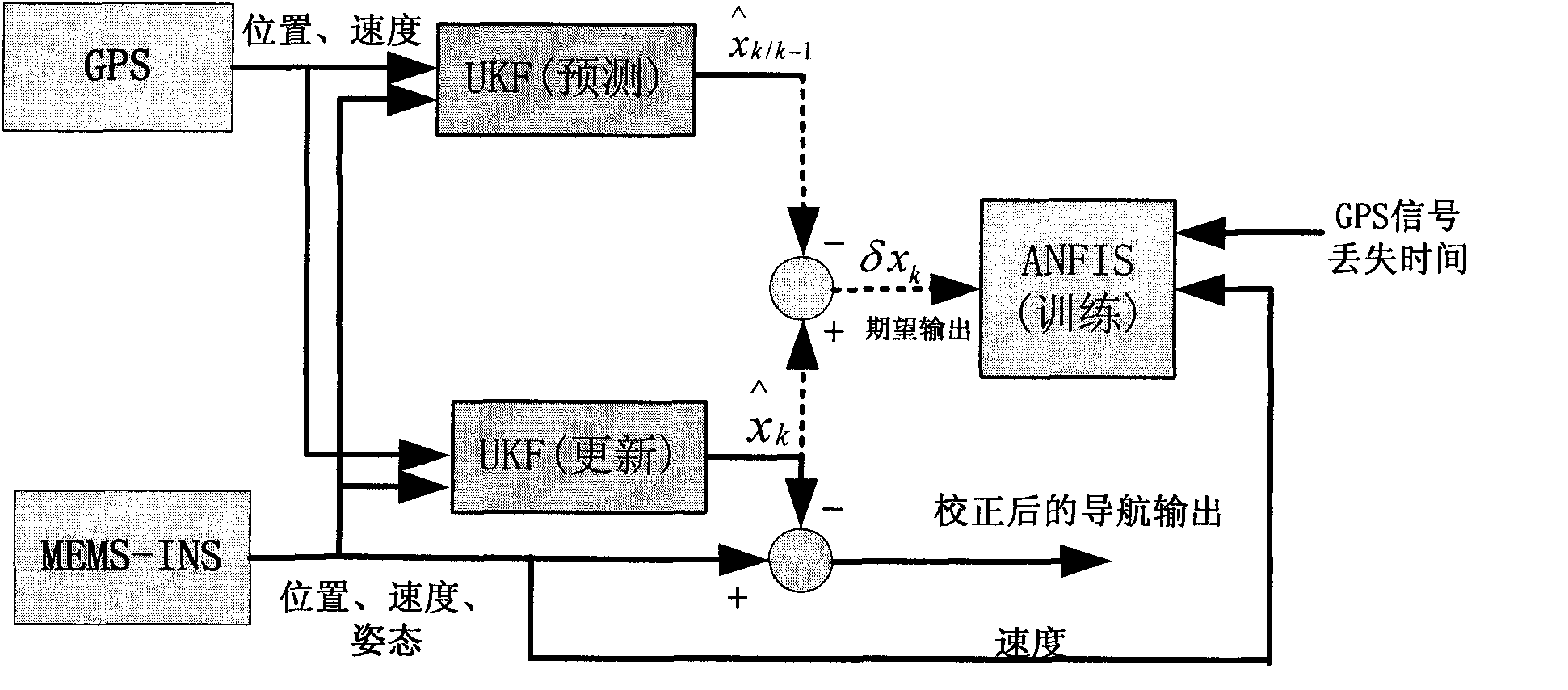
[0034] The structure diagram of ANFIS is as follows: figure 2 As shown, here it is assumed that the fuzzy inference system has two inputs: the speed V of the INS output INS and GPS signal loss time T GRS , and the single output is the position estimation error when the UKF is in the prediction state. Using the first-order Sugeno fuzzy model, assuming that each input corresponds to three fuzzy sets, the general rule set with M (here M is assumed to be 3) fuzzy if-then rules is as follows:

[0035] Rule i: If V INS ∈V i ,T GPS ∈ T i , then δP i =p i V INS +q i T GPS + r i , i=1, 2..., c

[0036] Here the nodes of the same layer have the same function (the output of the i-th node in layer 1 is O l,i ), the mathematical functions of each layer are introduced as follows:

[0037] Layer 1 Each node i in this layer is an adaptive node with a node function.

[0038] O 1 , i = ...


PUM


Abstract

The invention relates to a self-evolution ANFIS and UKF combined GPS/MEMS-INS integrated positioning error dynamic forecasting method. The method comprises the following steps of: (1) off-line confirming an ANFIS structure and an initial premise parameter according to a mass of experimental data comprising different motion characteristics of a carrier; (2) performing the self-evolution real-time updating of an ANFIS model by using an east, north and vertical velocity and GPS signal loss time outputted by the corresponding MEMS-INS under a UKF forecasting mode as input of the ANFIS and using an error value of a position error outputted under two modes of the UKF is used as expected output of the ANFIS, wherein the UKF comprises two concurrent working modes, namely, a forecasting mode and an updating mode, when a GPS/MEMS-INS integrated navigation system starts to work and the GPS signal is in good condition; and (3) forecasting the position error and correcting by a method of dynamically combining the ANFIS mode prediction with the UKF prediction when the GPS signal is lost and the ANFIS mode and the UKF work in a forecasting mode, and outputting the corrected integrated navigation system result. The method enhances the dynamic property and the adaptive ability of the ANFIS mode, and improves the position performance of the integrated navigation system.

Description

technical field [0001] The present invention relates to the field of positioning error prediction of a GPS / MEMS-INS (Micro Electro Mechanical System-Inertial Navigation System, micro-electromechanical system-based inertial navigation system, referred to as a micro-inertial navigation system) integrated navigation system, in particular to a self-evolving ANFIS (adaptive neuron navigation system) -Fuzzy inference system, adaptive neuro-fuzzy inference system) and UKF (Unscented Kalman Filter, Unscented Kalman Filter) combined GPS / MEMS-INS integrated navigation system, a dynamic prediction method for positioning errors when GPS signals are lost. Background technique [0002] In recent years, with the development of MEMS technology, MEMS inertial sensors have been widely used in the field of navigation and positioning. Its small size, light weight and low cost meet the basic requirements of most commercial applications for navigation systems. Due to the complementary characteri...

Claims


Application Information

Patent Timeline
IPC IPC(8): G01C21/00G01C21/16G01C21/20G01S19/01
CPCY02T10/56Y02T10/40
Inventor 秦红磊丛丽邢菊红
Owner BEIHANG UNIV
Why Eureka
Try Eureka