Three-dimensional visual navigation method based on multi-sensor information fusion

A multi-sensor and navigation method technology, applied in instruments, satellite radio beacon positioning systems, image data processing, etc., to achieve the effect of reducing the rate of flight accidents and improving the level of aviation safety management

Active Publication Date: 2010-09-15
内蒙古盛邦北斗卫星信息服务有限公司
View PDF2 Cites 48 Cited by
  • Summary
  • Abstract
  • Description
  • Claims
  • Application Information

AI Technical Summary

Problems solved by technology

Under complex weather conditions, the existing airport surveillance

Method used


Image

  • Three-dimensional visual navigation method based on multi-sensor information fusion
  • Three-dimensional visual navigation method based on multi-sensor information fusion
  • Three-dimensional visual navigation method based on multi-sensor information fusion

Examples


Embodiment Construction

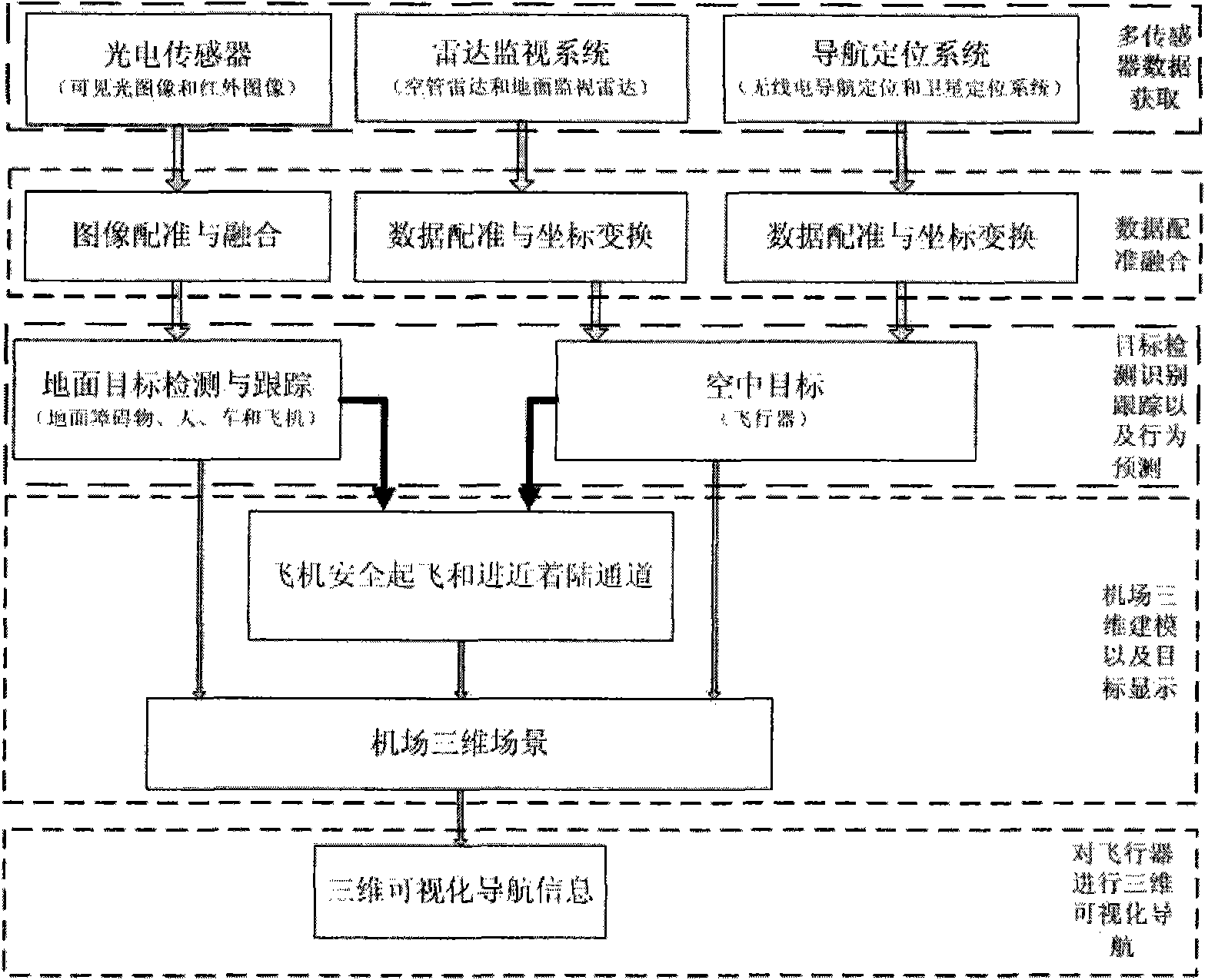
[0030] Such as figure 1 Shown, the concrete implementation method of the present invention is as follows:

[0031] (1) The steps to acquire multi-sensor data are:

[0032] ① Use the photoelectric sensor to obtain the infrared and visible light image data of the airport in real time and synchronously;

[0033] ② Use the airport radar surveillance system to obtain real-time target data in the air and on the ground;

[0034] ③ Use the navigation and positioning system to obtain the navigation and positioning data of the air target in real time.

[0035] (2) The steps of registering and fusing the multi-sensor data are:

[0036] ① Registration and fusion of visible light image and infrared image data;

[0037] ②Registration and coordinate transformation of radar surveillance system data;

[0038] ③Registration and coordinate transformation of the navigation and positioning system data.

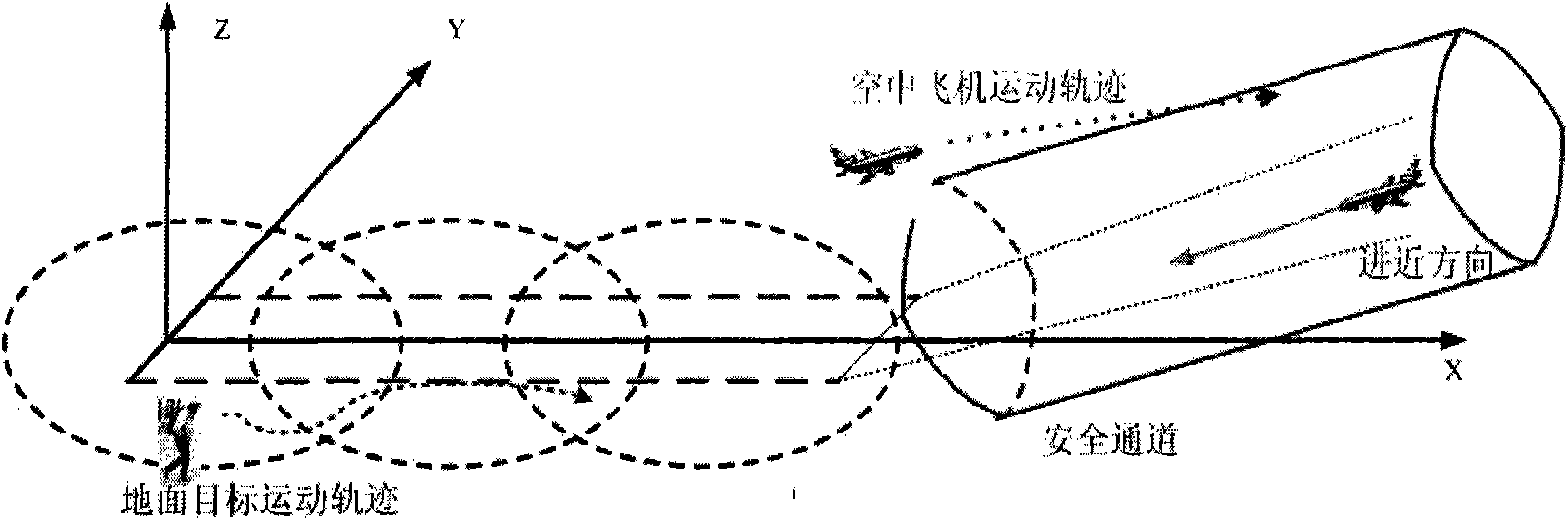
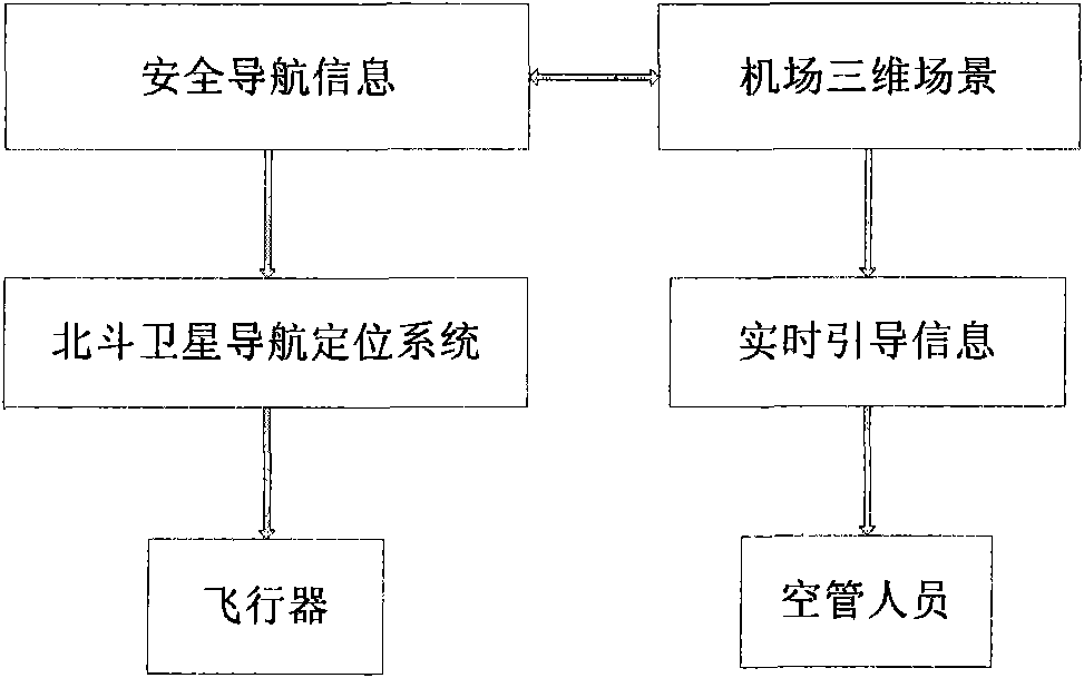
[0039] (3) Detect, identify and track air and ground targets, and predict target behavio...


PUM


Abstract

The invention relates to a three-dimensional (3D) visual navigation method based on multi-sensor information fusion. The multi-sensor data registration and fusion are finished based on acquiring multi-sensor data by means of a photoelectric sensor (infrared and visible lights), an airport radar monitor system (air traffic control radar and ground surveillance radar) and navigation positioning systems (radio navigation positioning system and global positioning system); and the detection, identification, track and behavior prediction are carried out on the targets (obstacles, humans, vehicles and planes) in the air or on the ground; the plane safety take-off and straight-in approach optimization information is automatically generated according to the target information in the air or on the ground; the target information and the plane safety take-off and straight-in approach optimization information are fused and displayed in an airport 3D scene to form a 3D visual navigation; and the system can automatically generate the 3D visual navigation information and transmits the navigation information to the aircraft via the GPS to realize the 3D visual navigation on the aircraft. The realization of the method comprises the following specific steps of: firstly, acquiring the multi-sensor data; secondly, registering and fusing the multi-sensor data; thirdly, detecting, identifying and tracking the targets in the air or on the ground by utilizing the fused data, and predicting the behavior of the targets; fourthly, establishing a 3D model of the airport, and fusing the targets and the behavior prediction data thereof and displaying the data in the airport 3D scene to form a 3D visual navigation system; and finally, carrying out the 3D visual navigation on the aircraft by means of the 3D visual navigation system to realize the safe take-off or approach of the aircraft.

Description

technical field [0001] The invention relates to a three-dimensional visual navigation method based on multi-sensor information fusion, which can be used in the field of aviation safety management, and can also be used in the three-dimensional visual navigation of aircraft, providing auxiliary decision-making information for airport ground air traffic control personnel and pilots, and improving the safe take-off and safety of aircraft. Approach and landing safety. Background technique [0002] In the existing air traffic control and navigation system, the surveillance radar is used to monitor and predict the trajectory of the aircraft, and the radio navigation and positioning system is used to complete the navigation and positioning calculation of the aircraft, and the air traffic controllers and pilots can realize the safe takeoff of the aircraft based on these information and landing. However, most of the runway intrusion events on the ground rely on people to complete the...

Claims


Application Information

Patent Timeline
IPC IPC(8): G01S19/42G06T17/50G06T17/05
Inventor 赵龙李铁军彭强强
Owner 内蒙古盛邦北斗卫星信息服务有限公司
Why Eureka
Try Eureka