Integrated forest fire dynamic monitoring and accurate positioning system and positioning method

A technology for dynamic monitoring and precise positioning, applied in the field of forest fire prevention, can solve the problems of low automation level of forest fire prevention monitoring, and achieve the effects of convenient management and observation, reduced purchase cost and high stability

Active Publication Date: 2010-10-13
NANJING FOREST POLICE COLLEGE
View PDF3 Cites 31 Cited by
  • Summary
  • Abstract
  • Description
  • Claims
  • Application Information

AI Technical Summary

Problems solved by technology

[0003] The purpose of the present invention is to design an integrated forest fire dynamic monitoring and precise positioning system with low cost, high automation level and accurate positioning to solve the problem of low automation lev

Method used


Image

  • Integrated forest fire dynamic monitoring and accurate positioning system and positioning method
  • Integrated forest fire dynamic monitoring and accurate positioning system and positioning method
  • Integrated forest fire dynamic monitoring and accurate positioning system and positioning method

Examples


Embodiment 1

[0037] Such as Figure 1-4 shown.

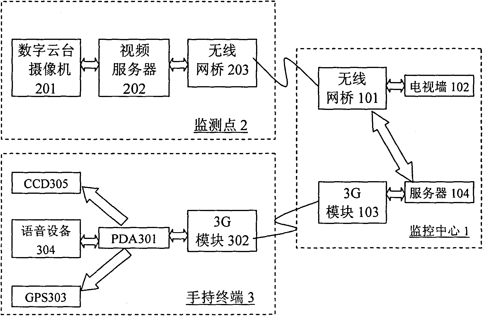
[0038] An integrated forest fire dynamic monitoring and precise positioning system, which is mainly composed of a monitoring center 1, an on-site monitoring transmission terminal 2 and a mobile handheld terminal 3, such as figure 1 shown. The monitoring center 1 mainly collects and processes data and displays the images captured by the on-site monitoring cameras on the TV wall in real time, and sends wireless instructions to the cameras and patrol personnel according to the actual measured on-site conditions. The on-site monitoring transmission terminal 2 is mainly According to the set program and the instructions of the monitoring center 1, the movement of the digital control pan-tilt camera is controlled, and the captured image is transmitted back to the monitoring center 1. The mobile handheld terminal 3 is mainly used by ground patrol personnel, and cannot be captured by the digital pan-tilt camera. It can supplement the area to be vis...

Embodiment 2

[0055] Such as Figure 5-8 shown.

[0056] An integrated forest fire dynamic monitoring and precise positioning method, which comprises the following steps:

[0057] 1) Set up several cameras in the forest area according to the visual range of the cameras, and transmit the captured images and the parameters matched with the images to the computer and the TV wall in the control center in real time through wired or wireless communication, and store the geographic location information of the cameras in the In the computer of the control center;

[0058] 2) Determine the source of the fire using the single-point positioning method, that is, when any of the cameras captures the picture of the fire point, immediately determine the position of the fire point by the following methods:

[0059] First, by returning the information about the camera carried in the image, determine the rotation angle of the camera relative to the true north direction, so as to determine the direction of ...


PUM


Abstract

The invention relates to an integrated forest fire dynamic monitoring and accurate positioning system and method. The invention is characterized in that the positioning system mainly comprises a monitoring center (1), an on-site monitoring and transmission terminal (2) and a mobile hand-held terminal (3), wherein a PDA (301) in the mobile hand-held terminal (3) is connected with a 3G module (101) in the monitoring center (1) through a 3G module (302) in a two-way wireless manner, a 3G module (103) is connected with a server (104), the server (104) is connected with a wireless bridge (101), the wireless bridge (101) is connected with a TV wall (102) and in double-way connection with the wireless bridge (203) of the on-site monitoring and transmission terminal (2), the wireless bridge (203) is in double-way connection with a video server (202), and the video server (202) is in double-way connection with a digital camera (201) with a tripod head; and the method of the invention is mainly as follows: the successive approximation exhaust method and the bisection method are combined with the rotation angle and pitch angle of the camera to fast calculate the position of the fire point. The system of the invention has high automation level, simple structure and low cost, is easy to realize and control and can perform quick positioning to the fire point.

Description

technical field [0001] The present invention relates to a forest fire prevention method and system, especially a forest fire prevention positioning method and a rapid positioning system capable of real-time monitoring and positioning of forest fires, specifically an integrated forest fire dynamic monitoring and precise positioning method and system. Background technique [0002] As we all know, traditional fire monitoring and positioning generally rely on manual patrols and manual lookouts for monitoring. When there is a fire, the observer judges the location of the fire based on experience and familiarity with the forest farm. At present, my country's forest fire monitoring system is still based on artificial ground patrol and fixed-point lookout, supplemented by aerial patrol and satellite detection. Manual patrols and artificial lookouts have problems such as limited field of view, and continuous monitoring will cause visual fatigue and mental fatigue. Aviation patrols ...

Claims


Application Information

Patent Timeline
IPC IPC(8): H04L29/08H04L29/06H04N7/18
Inventor 丛静华沈明霞何瑞银汪东许水燕刘龙申张瑜李龙国
Owner NANJING FOREST POLICE COLLEGE
Why Eureka
Try Eureka