Airborne laser measurement-based highway reconstruction and expansion investigation method

A laser measurement and airborne laser technology, which is applied in roads, roads, buildings, etc., can solve the problems of low efficiency of manual measurement, heavy workload, high cost of manpower and material resources, achieve significant economic and social benefits, and is conducive to design and comparison, reducing the effect of field workload

A laser measurement and airborne laser technology, which is applied in roads, roads, buildings, etc., can solve the problems of low efficiency of manual measurement, heavy workload, high cost of manpower and material resources, achieve significant economic and social benefits, and is conducive to design and comparison, reducing the effect of field workload

CN101914890BActive Publication Date: 2011-11-16CCCC SECOND HIGHWAY CONSULTANTS CO LTD

Image

  • Airborne laser measurement-based highway reconstruction and expansion investigation method
  • Airborne laser measurement-based highway reconstruction and expansion investigation method
  • Airborne laser measurement-based highway reconstruction and expansion investigation method

Examples


Embodiment Construction

[0029] The method of the present invention will be further described in detail below through specific implementation manners and in conjunction with the accompanying drawings.

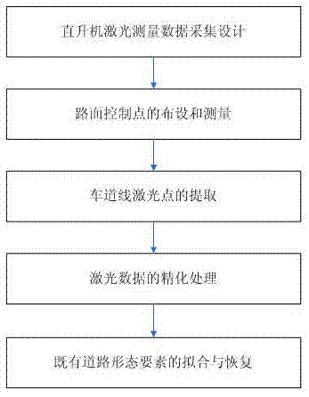
[0030] A road reconstruction and expansion survey method based on airborne laser measurement, its flow chart is as follows figure 1 shown.

[0031] The standards and norms implemented during the implementation process are:

[0032] "1:500, 1:1000, 1:2000 Scale Topographic Map Aerial Photography Specification" (GB / T6962-2005)

[0033] National Bureau of Surveying and Mapping "IMU-DGPS Aided Aerial Photography Technical Regulations" (Trial)

[0034] The General Administration of Quality Supervision, Inspection and Quarantine of the People's Republic of China and the Standardization Administration of China "Global Positioning System (GPS) Measurement Specifications" (GB / T 18314—2009)

[0035] Ministry of Communications of the People's Republic of China "Highway Survey Specification" (JTG C10-2007)

[...


PUM


Abstract

The invention discloses an airborne laser measurement-based highway reconstruction and expansion investigation method. The method comprises the following steps of: A, acquiring information of an existing highway through laser measurement by taking a helicopter as a platform according to a design route scheme and designing a flying task; B, arranging and measuring road surface control points; C, extracting an accurate lane line by a man-machine interaction mode and using strength information of a laser dot; D, fining a plane and elevation of original road surface laser dot data by using the road surface control points and the extracted lane line, and fining the extracted lane line laser dot data at the same time; and E, fitting and restoring form elements of the existing highway. The method of the invention quickly and accurately acquires three-dimensional spatial information required for the construction of a highway reconstruction and expansion project under the condition of not interrupting the traffic, so the manual measurement on the highway is replaced, the personal safety of the measurement personnel is ensured to the greatest extent, the outdoor workload is extremely reduced, the working efficiency is greatly improved and obvious economic benefit and social benefit are achieved.

Description

technical field [0001] The present invention relates to the technical field of highway survey and design, and more specifically relates to a highway reconstruction and expansion survey method based on airborne laser measurement. The needs of highway reconstruction and expansion under traffic conditions. Background technique [0002] Since the 1980s, the construction of expressways in our country has developed vigorously, and it has been nearly 30 years so far. However, with the continuous and rapid development of the social economy, the traffic volume of expressways is increasing day by day, and many early-built expressways can no longer fully meet the needs of today's traffic volume development, such as Shenyang University, Guangfo, Shanghai-Nanjing, Beijing-Tianjin-Tang and Beijing-Hong Kong-Macau expressways, thereby restricting economic and social development. It is estimated that in the next five to ten years, at least one-third of the more than 40,000 kilometers of e...

Claims


Application Information

Patent Timeline
16 Nov 2011
Publication
CN101914890B
IPC
E01C23/01
Inventors
陈楚江; 明洋