Method for remote sensing monitoring and predicting protein content of winter wheat grains

A protein content, winter wheat technology, applied in the field of agricultural remote sensing technology, can solve the problems of lack of mechanism and universality, and achieve the effect of promoting development

Inactive Publication Date: 2011-08-17
JIANGSU ACADEMY OF AGRICULTURAL SCIENCES
View PDF2 Cites 12 Cited by
  • Summary
  • Abstract
  • Description
  • Claims
  • Application Information

AI Technical Summary

Problems solved by technology

Most of these studies are empirical models based on the linear relationship between remote sensing parameters and protein content during the growth period of winter wheat, which lack mechanism and universality.

Method used


Image

  • Method for remote sensing monitoring and predicting protein content of winter wheat grains
  • Method for remote sensing monitoring and predicting protein content of winter wheat grains
  • Method for remote sensing monitoring and predicting protein content of winter wheat grains

Examples


Embodiment Construction

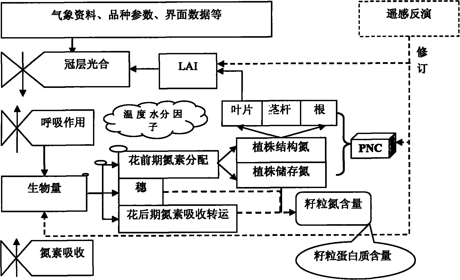
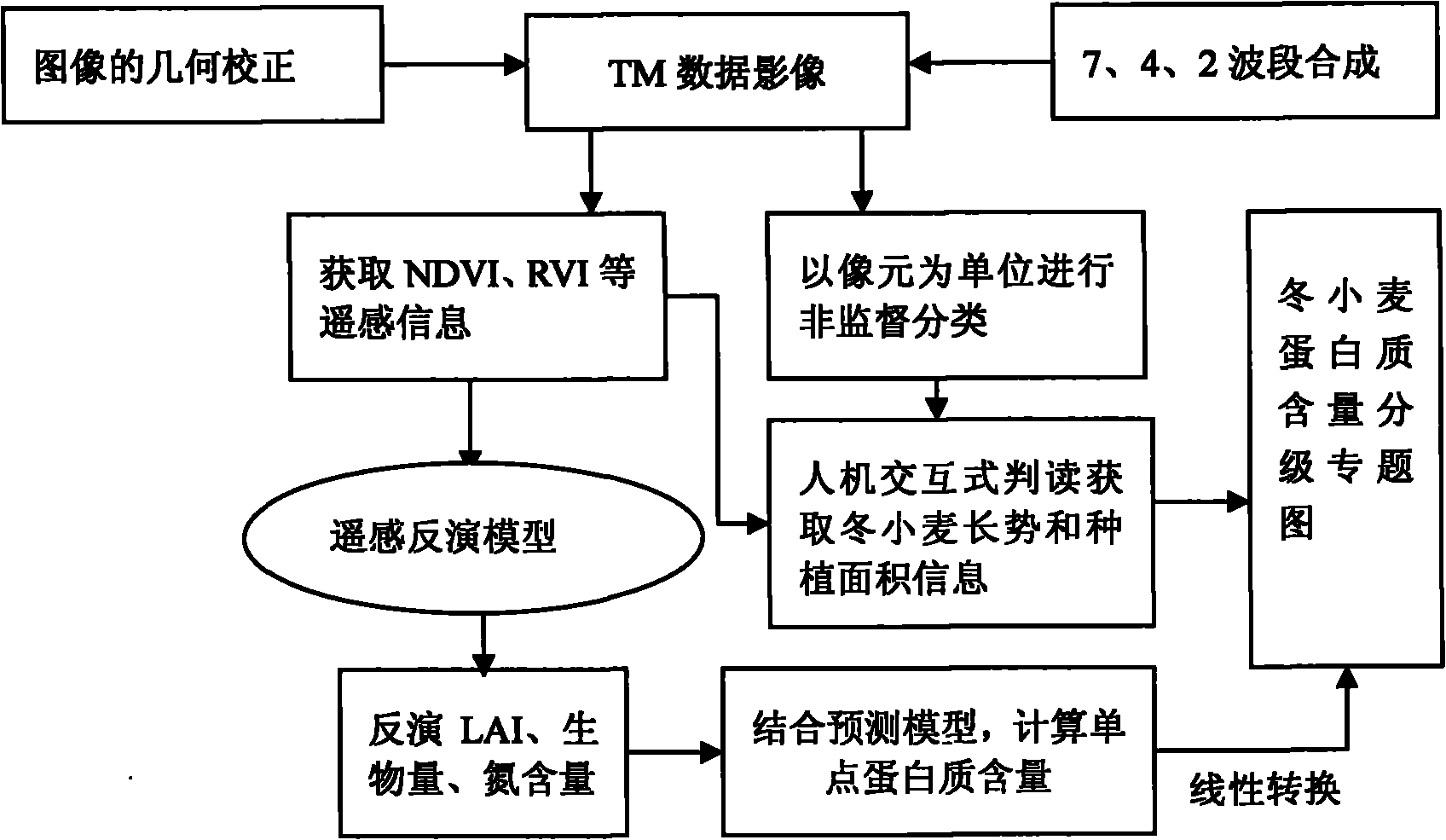
[0044] 1. Materials and methods

[0045] 1.1 Materials

[0046] The image data used is the Landsat-TM image of the US Land Resources Satellite, and its transit time in Jiangyan City is May 2, 2008. The weather was fine that day, with no or few clouds, and the imaging quality was good. While using the ERDAS IMAGINE software to perform geometric correction on the image data, combined with the GPS control points measured on the ground for geometric precision correction, to ensure that the error after correction is less than 1 pixel.

[0047] The establishment of the ground control points adopts the latest Juno ST handheld GPS receiver from Trimble Company of the United States, and selects 20 test quadrat points and 4 An experimental base with a large area, collecting geographical coordinates, measuring the actual range and area, and recording the growth status of winter wheat varieties, leaf area, biomass, and plant nitrogen content.

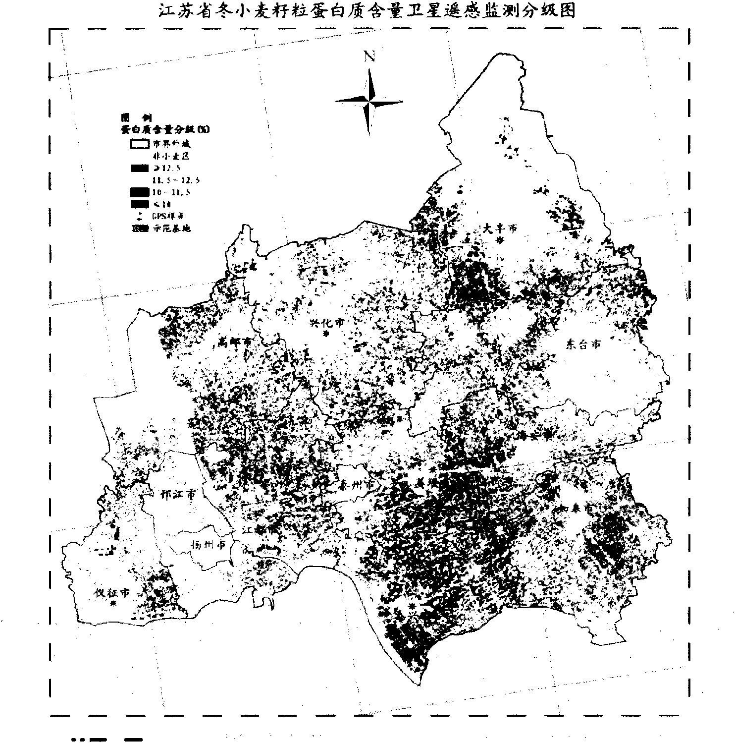
[0048] 1.2 Grading monitoring and forecas...


PUM


Abstract

The invention provides a method, comprising the steps of: based on the instantaneity and wide regional coverage for obtaining remote sensing information, building a grain protein content prediction model based on nitrogen accumulation procedure via combining with the influencing characteristics of climatic environmental conditions in the flowering duration of wheat on the formation of grain quality; realizing the coupling of the remote sensing information and a grain protein content prediction model, namely using LAI (leaf area index), biomass and plant nitrogen content data inverted by flowering duration remote sensing images to displace the corresponding parameter variables of the wheat grain protein content prediction model, so as to realize the prediction for the protein content of single-point wheat grains, wherein the prediction precision is more than 85%; and drawing a graded monitoring and predicting thematic map for protein content of winter wheat grains by a scaling converting method of 'point' (the protein content of sample point grains) and 'face' (remote sensing images). The method has the characteristics of intuitionism and good timeliness, and has relatively good practicability for obtaining regional wheat quality information or guiding grain collection by department of agriculture.

Description

1. Technical field [0001] The method of the invention relates to a crop quality remote sensing monitoring method, in particular to a wheat quality remote sensing monitoring and forecasting method capable of dynamically monitoring and forecasting the protein content of winter wheat grains within an area and making a thematic information map of the protein content. It belongs to the application field of agricultural remote sensing technology. 2. Background technology [0002] Wheat is an important food crop in the world, and it is the second largest food crop after rice in my country. Its yield and quality are directly related to the supply and nutritional level of human food. Among them, the improvement of quality traits plays a very important role and significance in enriching people's food sources and improving economic and social benefits. Protein content is the most important factor determining the use of wheat flour. According to the amount of protein content, it can be...

Claims


Application Information

Patent Timeline
Patent Type & Authority Applications(China)
IPC IPC(8): G01N21/84G06F19/00
Inventor 李卫国王纪华赵春江
Owner JIANGSU ACADEMY OF AGRICULTURAL SCIENCES
Why Eureka
Try Eureka