Real-time kinematic GPS (RTK-GRS) and total station integrated topographic surveying method and system with encoded data

A technology of RTK-GPS, terrain measurement system, applied in the field of electric power engineering measurement, can solve the problems of consuming human resources, prone to errors, low efficiency, etc., to improve the drawing efficiency, avoid manual search for measuring points, and save human resources.

Active Publication Date: 2011-09-28
CHINA ENERGY ENG GRP GUANGDONG ELECTRIC POWER DESIGN INST CO LTD
View PDF5 Cites 8 Cited by
  • Summary
  • Abstract
  • Description
  • Claims
  • Application Information

AI Technical Summary

Problems solved by technology

Applying these two surveying and mapping methods, the field is responsible for collecting data and drawing sketches, and the interior is only responsible for processing the data. The operations of the interior and field are disconnected from each other. In addition, how to connect ground objects can only rely on the manual drawing of ground by field personnel. Therefore, when data processing is performed by the office personnel, it is necessary to manually search for all the measuring points of each feature in the field sketch against the hundreds of measuring points of the day, and then connect them point by point. l

Method used


Image

  • Real-time kinematic GPS (RTK-GRS) and total station integrated topographic surveying method and system with encoded data
  • Real-time kinematic GPS (RTK-GRS) and total station integrated topographic surveying method and system with encoded data
  • Real-time kinematic GPS (RTK-GRS) and total station integrated topographic surveying method and system with encoded data

Examples


Embodiment Construction

[0026] The solution of the present invention will be described in detail below with one of the preferred embodiments.

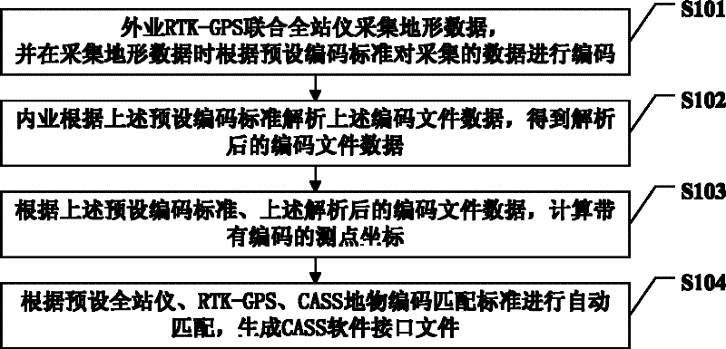
[0027] Such as figure 2 As shown, it is a schematic flow chart of an embodiment of the RTK-GPS horizontal section surveying and drawing method of the present invention. Such as figure 2 As shown, it includes the steps:

[0028] Step S101: Field RTK-GPS unites the total station to collect terrain data, and encodes the collected data according to the preset coding standard when collecting data, specifically, according to the preset RTK-GPS coding standard to encode the data collected by RTK-GPS Encode the data to obtain the RTK-GPS encoded file data, encode the data collected by the total station according to the preset total station encoding standard, obtain the total station encoded file data, and enter step S102;

[0029] Step S102: The office analyzes the above encoded file data according to the above preset encoding standard to obtain the analyzed enc...


PUM


Abstract

The invention relates to a real-time kinematic GPS (RTK-GRS) and total station integrated topographic surveying method and system with encoded data. When the data is surveyed outside, data collected by the RTK-GRS and the total station is respectively encoded according to a preset RTK-GRS coding standard and a preset total station coding standard. The function of two devices with high working efficiency is exerted without drawing a sketch map by handmade for saving the human resource. When the office work is processed, the surveying points of the landmarks can be automatically analyzed according to the same preset RTK-GPS coding standard and the same total station coding standard through the observation data with object codes collected outside, An automatic matching is conducted accordingto the landmark coding coupling standards of the preset total station, the RTK-GPS, a CASS for generating a CASS software interface file, and a topographic map can be automatically drawn by using a CASS software. The defects that a measuring point is searched by person and points are connected one by one by people can be avoided. The t real-time kinematic GPS (RTK-GRS) and total station integrated topographic surveying can be realized and the drafting efficiency can be improved.

Description

technical field [0001] The invention relates to the technical field of electric power engineering measurement, in particular to an integrated terrain measurement method and system with a coded RTK-GPS total station. Background technique [0002] At present, in domestic topographic map measurement technology, there are two common methods, one is to use total station topographic surveying and mapping topography and ground objects, and the other is RTK-GPS (Real-Time Kinematic GPS, dynamic real-time global positioning system) measurement method. [0003] The main method of the total station topographic survey is to collect all the detailed points and draw operations in the field, and the office personnel calculate the coordinates of all the survey points of the total station, and display all survey points on the map (usually, using AutoCAD as the platform) According to the field sketch, find the measuring points in the sketch in a large number of fragmentary points, and connec...

Claims


Application Information

Patent Timeline
IPC IPC(8): G01C7/02G01S19/14
Inventor 雷伟刚王东甫张小望柳林
Owner CHINA ENERGY ENG GRP GUANGDONG ELECTRIC POWER DESIGN INST CO LTD
Why Eureka
Try Eureka