System with wide geographical coverage for monitoring positions in real time

A real-time location and monitoring system technology, applied in the direction of radio wave measurement system, satellite radio beacon positioning system, transmission system, etc., can solve the problems of poor real-time performance, poor information confidentiality, and inability to cover remote areas

Inactive Publication Date: 2011-11-16
NAT ASTRONOMICAL OBSERVATORIES CHINESE ACAD OF SCI
View PDF8 Cites 15 Cited by
  • Summary
  • Abstract
  • Description
  • Claims
  • Application Information

AI Technical Summary

Problems solved by technology

[0004] 1. GSM, CDMA and other mobile communication networks and the Internet cannot cover some remote areas, and cannot meet the direct transmission of signals in a wide area;
[0005] 2. The transmission of information needs to be transferred through the base station and the third-party service network. The confidentiality and real-time performance of the information are not good;
[0006] 3. Uninterrupted monitoring of multiple terminals at the same time, the cost is high

Method used


Image

  • System with wide geographical coverage for monitoring positions in real time
  • System with wide geographical coverage for monitoring positions in real time
  • System with wide geographical coverage for monitoring positions in real time

Examples


Embodiment 1

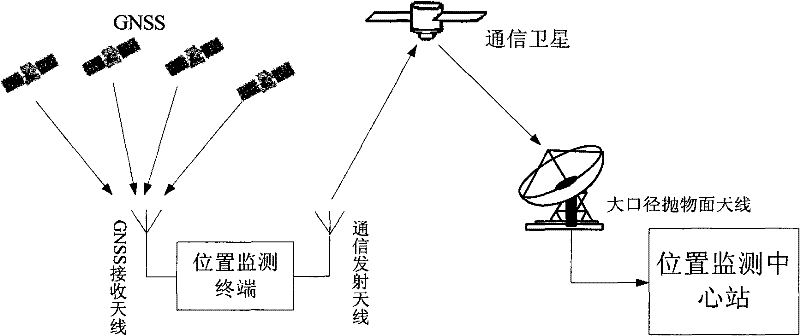
[0044] refer to figure 1 , making an inventive real-time location monitoring system covering a wide area.

[0045] In this embodiment, the system of the present invention is composed of a position monitoring terminal, a position monitoring central station, communication satellites and a GNSS positioning system.

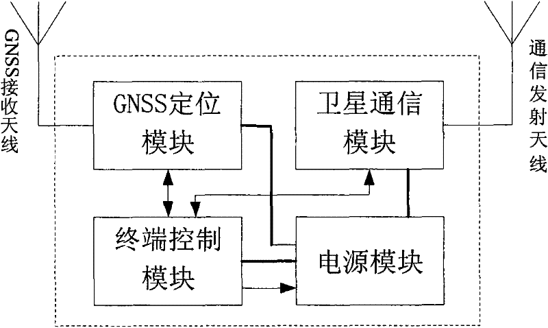
[0046] The position monitoring terminal is used to obtain position and time information, and transmits the position information to the position monitoring central station through a satellite link, and is mainly composed of a GNSS positioning module, a satellite communication module, a terminal control module and a power supply module, such as figure 2 shown.

[0047] When the position monitoring terminal is working, the power supply module supplies power to the terminal control module and the GNSS positioning module; the GNSS module locates by receiving the GNSS signal, obtains the position time information, and transmits the information to the terminal control module...

Embodiment 2

[0066] see Figure 5 , multiple detectors are installed on the location monitoring terminal of the embodiment, and other detection data can also be transmitted to realize the monitoring of some parameters of the location, for example, 5 detectors can be installed, including temperature detectors, air humidity Detectors, air pressure detectors, meteorological parameter detectors and geological parameter detectors, the detectors are used to measure the temperature, air humidity, air pressure, meteorological parameters and geological parameters where the terminal is located; and through a certain interface, this embodiment uses The serial port can also use the network port or USB port. The serial port is connected to the terminal control module; the terminal control board collects the data of these detectors, frames the detection data, and sends them to the monitoring center station through the satellite communication module to realize the monitoring center station. Real-time mon...

Embodiment 3

[0071] refer to Image 6 , in the real-time position monitoring system of embodiment 1, also include a data distribution communication network, in this embodiment, the data distribution communication network adopts a computer network. Other parts of the system are implemented in the same way as in Embodiment 1 and Embodiment 2. The location monitoring central station provides real-time or regular terminal data to specific users through the data release communication network for real-time analysis by specific users and observation of various detection data distributed in a wide area.

[0072] The data distribution communication network can also be a satellite communication network or a mobile communication network. It can be realized by the traditional computer Internet, satellite communication or mobile communication technology, which can be realized by those skilled in the art. Corresponding communication equipment is added to the location monitoring central station to inte...


PUM


Abstract

The invention relates to a system with wide geographical coverage for monitoring positions in real time, comprising position monitoring terminals, a communication satellite and a position monitoring central station, wherein the position monitoring terminals comprise a GNSS (global navigation satellite system) positioning module, a satellite communication module, a control module and a power supply module respectively; the communication satellite is a synchronous orbit communication satellite; the position monitoring central station comprises a heavy caliber parabolic antenna, a satellite communication receiver and a data processing computer; and the position monitoring terminals are used for passing positioning information acquired by the positioning modules back to the monitoring central station by a satellite link, so that the central station can monitor the positions of the position monitoring terminals in real time. In the monitoring system, bandwidth resources of one satellite transponder are utilized, and an FDMA (frequency division multiple access) way, a CDMA (code division multiple access) way and a TDMA (time division multiple access) way are adopted to monitor the positions of the multiple position monitoring terminals in real time. The system is applied to regions with satellite signal coverage only without ground communication network coverage particularly. The system has the characteristics of instantaneity, multiple users and wide geographical coverage.

Description

technical field [0001] The present invention relates to a position monitoring and data transmission system, in particular to a real-time position monitoring system covering a wide area, which uses the functions of satellite positioning and satellite communication to monitor the positions of multiple position monitoring terminals in real time at the same time . Background technique [0002] In order to monitor the position of multiple terminals such as scientific research detection devices in real time, the usual practice is to install a GNSS positioning module on the terminal to obtain position information, and send the position information to the monitoring central station, which manages the position information of all terminals. Wherein, the location information is sent to the monitoring central station, and the existing method is generally realized through the ground mobile communication network and the Internet. For example, reference 1: Utility Model Patent No. ZL 0221...

Claims


Application Information

Patent Timeline
Patent Type & Authority Applications(China)
IPC IPC(8): H04B7/185G01S19/03
Inventor 范江涛马冠一李婧华张杰
Owner NAT ASTRONOMICAL OBSERVATORIES CHINESE ACAD OF SCI
Why Eureka
Try Eureka