Global Land Surface Broadband Emissivity Inversion Method and System

An emissivity, wide-band technology, applied in the field of satellite remote sensing, can solve the problems of poor spatial continuity of emissivity products, difficult to deal with high vegetation areas and low vegetation areas, etc.

Inactive Publication Date: 2011-12-28
BEIJING NORMAL UNIVERSITY
View PDF1 Cites 20 Cited by
  • Summary
  • Abstract
  • Description
  • Claims
  • Application Information

AI Technical Summary

Problems solved by technology

However, their results mostly come from the statistics of ground measurement data or limited remote sensing data, and it is difficult to deal with the situation of high vegetatio

Method used


Image

  • Global Land Surface Broadband Emissivity Inversion Method and System
  • Global Land Surface Broadband Emissivity Inversion Method and System
  • Global Land Surface Broadband Emissivity Inversion Method and System

Examples


Embodiment Construction

[0050] The specific implementation manners of the present invention will be further described in detail below in conjunction with the accompanying drawings and embodiments. The following examples are used to illustrate the present invention, but are not intended to limit the scope of the present invention.

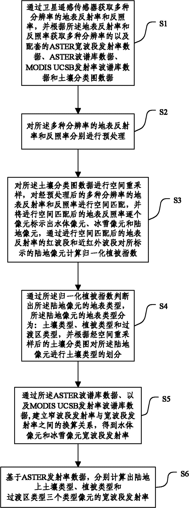
[0051] figure 1 It is a flowchart of a wide-band emissivity inversion method according to an embodiment of the present invention, comprising the following steps:

[0052] S1: The surface reflectance and albedo of various resolutions are acquired by the Moderate Resolution Imaging Spectroradiometer (MODIS) or the Advanced Very High Resolution Radiometer (AVHRR) satellite remote sensing sensor, and according to The surface reflectance and albedo obtain multi-resolution and supporting ASTER broadband emissivity data, ASTER spectral library data, MODIS UCSB emissivity spectral library data and soil classification map data;

[0053] In this embodiment, the remote sensing data...


PUM


Abstract

The invention relates to the satellite remote sensing technology field and especially relates to a global land cover broadband emissivity inversion method and a system. The method comprises the following steps: S1. acquiring a surface reflectivity with a plurality of resolutions and an albedo and acquiring matched soil classification graph data; S2. carrying out pretreatment respectively to the surface reflectivity with a plurality of resolutions and the albedo; S3. carrying out spatial resample to the soil classification graph data, carrying out spatial matching to the pretreated surface reflectivity with a plurality of resolutions and the albedo and identifying each pixel of the spatial matched surface albedo; S4. determining a surface type of the land pixel; S5. establishing a conversion relation between the narrowband emissivity and the broadband emissivity so as to obtain the broadband emissivity of the water body pixel and the ice and snow pixel; S6. calculating the broadband emissivity of the pixel. In the invention, precision of broadband emissivity inversion can be improved through processing reflectivity data and albedo data.

Description

technical field [0001] The invention relates to the technical field of satellite remote sensing, in particular to a method and system for retrieving global land surface wide-band emissivity. Background technique [0002] The surface emissivity is an inherent characteristic of the surface, which is affected by the composition, water content, and roughness of the surface, and can describe the strength of the surface's thermal radiation ability. Surface emissivity is indicative of the mineral composition in rocks, and is often used in lithology identification and geological mapping. In addition to its important influence on the estimation of surface temperature, surface emissivity and surface temperature determine the long-wave radiation in the surface radiative energy balance, which is a key input parameter in climate, hydrology, ecology and biogeochemical models. [0003] Remote sensing is the only means of obtaining land surface emissivity on regional and global scales. Ho...

Claims


Application Information

Patent Timeline
IPC IPC(8): G01S17/89G01S7/48
Inventor 赵祥程洁任华忠高涛梁顺林
Owner BEIJING NORMAL UNIVERSITY
Why Eureka
Try Eureka