Method for determining minimum distance of road intersections in harbor district

A method for determining the intersection and intersection technology, applied in the direction of roads, roads, buildings, etc., can solve the problems of complex description, undiscovered large-scale vehicles in the port area, and unclear impact mechanism research.

Active Publication Date: 2012-05-02
TIANJIN MUNICIPAL ENG DESIGN & RES INST
View PDF3 Cites 25 Cited by
  • Summary
  • Abstract
  • Description
  • Claims
  • Application Information

AI Technical Summary

Problems solved by technology

[0004] (1) The research object of the minimum distance between road intersections is mainly urban cars, and there is no relevant literature on the research on the distance between road entrances and exits of large vehicles in the port area;
[0005] (2) The research on the influence mechanism of driving behavior and traffic conflicts of vehicles entering the intersection functional area is not clear in the existing technology, that is, the lane change of individual vehicles, vehicle following, etc., while the driving behavior of individual vehicles in the intersection functional area 1. Traffic conflict research is the basis for exploring the relationship between intersection spacing, road network traffic efficiency and traffic safety. The description of this process is very complicated, especially for large vehicles in ports.
[0006] According to the analysis of the above-mentioned background technology, it can be seen that the existing domestic and foreign research technologies on the minimum distance between road intersections include data statistical analysis, micro-traffic simulation software, safe distance calculation, maximum green wave design, queuing length estimation, etc. In-depth research on the complex driving behavior and the impact mechanism of traffic conflicts in the entrance function area, and the current research technology lacks basic research support

Method used


Image

  • Method for determining minimum distance of road intersections in harbor district
  • Method for determining minimum distance of road intersections in harbor district
  • Method for determining minimum distance of road intersections in harbor district

Examples


Embodiment Construction

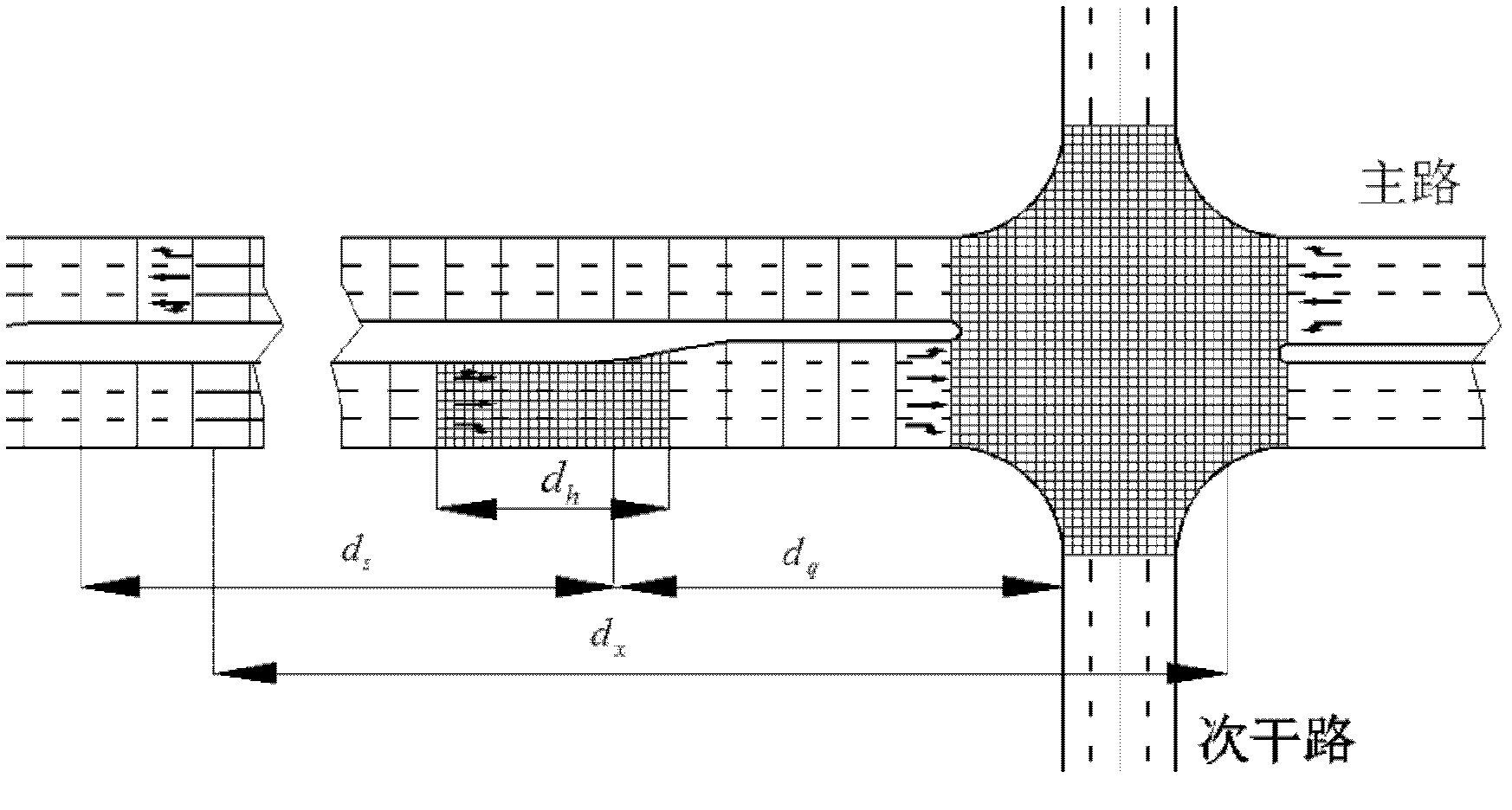
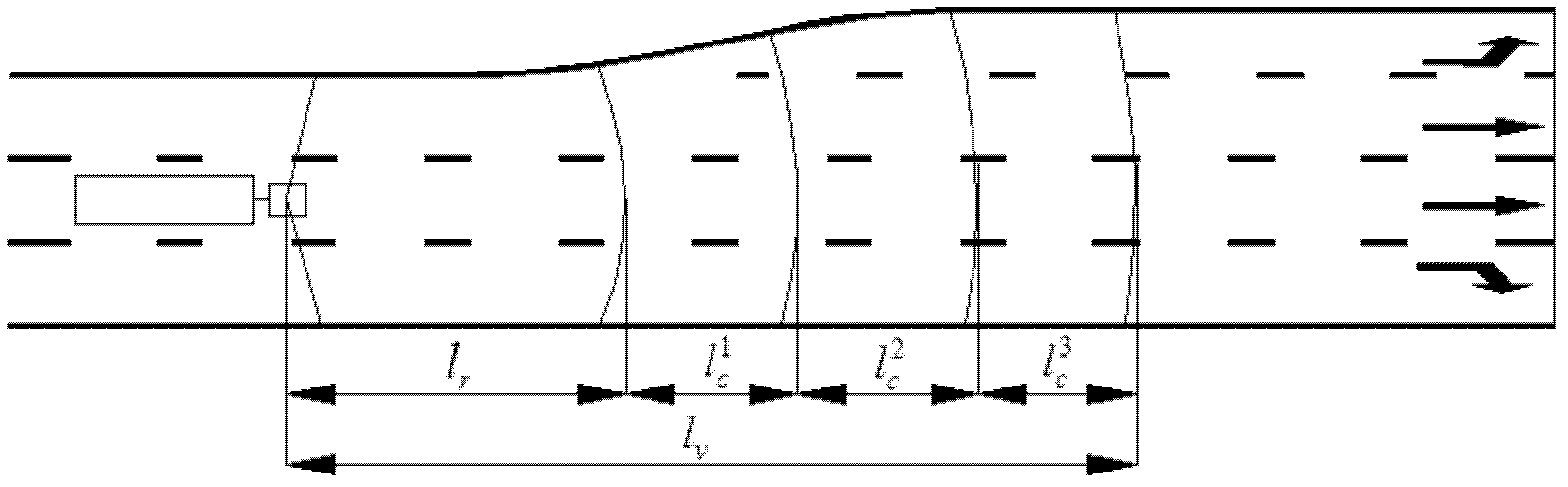
[0056] (1) Division of road cells

[0057] Carry out two-dimensional cell division for the frequent lane-changing areas and intersections of vehicles on the road near the intersection and the port area, and use one-dimensional cells for construction of other parts. The road and intersection cell division method of the present invention is as follows: figure 1 As shown, the reason for two-dimensional cell division in frequent lane-changing areas and intersections is that due to the particularity of large vehicles, their turning time is longer and the trajectory is more complicated. One-dimensional cells place vehicles in one step The process of adjacent cells is not enough to describe the lane changing and turning process of large vehicles.

[0058] (2) Construction of perception module

[0059] 1) Congestion perception of the lane ahead

[0060] When a vehicle approaches a road intersection, the degree of influence of vehicles in the front lanes has a great influence on the...


PUM


Abstract

The invention belongs to the technical field of road design, and relates to a method for determining the minimum distance of road intersections in a harbor district. In the method, frequent lane-changing area of harbor district roads connected with the intersections and the intersections are subjected to two-dimensional cell division, and other parts are one-dimensional cells, and a cell model for harbor district roads near the intersections is constructed. The method comprises the following steps of: (1) constructing a driver sensing module; (2) constructing a behavior module; and (3) setting appearing ratios of various vehicles in a main road, speeds of the various vehicles, and departure frequencies of various vehicles, performing simulation experiments under the conditions of different distances of the intersections and different departure frequencies, and analyzing the simulation to obtain a traffic flow space-time map and vehicle delay data so as to obtain the minimum distance of proper intersections under different traffic conditions. By the method, the influence of the distance of the intersections on the road capacity of the harbor district can be accurately reflected, sothat a method for determining the distance of the road intersections in the harbor district under different conditions is provided.

Description

technical field [0001] The invention belongs to the technical field of road design and relates to a method for determining the minimum distance between road intersections in a port area. Background technique [0002] From the relevant literature at home and abroad, it can be seen that the existing minimum distance research technology for road intersections is based on road network traffic efficiency and traffic safety design. Traffic safety mainly focuses on the relationship between the minimum distance between intersections and the intersection traffic design such as intersection channelization design, sign marking design, and intersection sight distance. The National Cooperative Highway Research Project (NCHRP) research report Project 3-33 published by the US Transportation Research Board (TRB) in 1994, used in traffic volume surveys and data statistical analysis techniques, proved that intersection spacing is related to road free flow speed, road Traffic accidents are cl...

Claims


Application Information

Patent Timeline
Patent Type & Authority Applications(China)
IPC IPC(8): E01C1/00
Inventor 赵巍白子建王晓华李伟刘伟郑利邢锦王海燕刘虹刘大为柯水平周骊巍杨福增李东练象平曾伟靳灿章段绪斌冯炜张磊杜鹏李明剑张国梁代茂华狄升贯张洋张占领
Owner TIANJIN MUNICIPAL ENG DESIGN & RES INST
Why Eureka
Try Eureka