Beidou satellite system-based tide level data transmission and control method

A Beidou satellite and data transmission technology, applied in satellite radio beacon positioning system, signal transmission system, radio wave measurement system, etc., can solve the problems of poor communication effect, unsuitable production demand, affecting the comprehensive management of tide level data, etc. , to achieve the effect of improving accuracy, improving construction efficiency, and ensuring communication reliability

Inactive Publication Date: 2012-05-09
上海达华测绘科技有限公司
View PDF0 Cites 13 Cited by
  • Summary
  • Abstract
  • Description
  • Claims
  • Application Information

AI Technical Summary

Problems solved by technology

With the continuous extension of the survey and construction area to the open sea, the transmission distance is getting longer and longer. Due to the limitation of external communication conditions, the transmission of tide level data has become the bottleneck of tide level data information acquisition and management control. At the same time, with the development of urban construction, Changes in the electromagnetic environment lead to poor communication effects. The original traditional "audio modem + analog radio station" tide level information transmission method has gradually become unsuitable for production needs, and it is likely to affect normal production and comprehensive management of tide level data.

Method used


Image

  • Beidou satellite system-based tide level data transmission and control method
  • Beidou satellite system-based tide level data transmission and control method
  • Beidou satellite system-based tide level data transmission and control method

Examples


Embodiment Construction

[0027] The present invention will be further described below in combination with principle diagrams and specific operation examples.

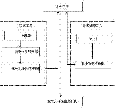
[0028] see figure 2 , the inventive method mainly comprises data acquisition process and data processing release process, and wherein, data acquisition process is: the collector that is positioned at the data acquisition unit of tide level station sends the tide level data analog signal that gathers to data A / D converter, After the analog signal is converted into a digital signal by the data A / D converter, it is transmitted to the first Beidou communication receiver; the data processing and publishing process is: the first Beidou communication receiver sends the tide level data to the control unit based on the Beidou satellite system On the Beidou communication command plane, the Beidou communication command plane then transmits the data to the PC. The PC performs filtering, curve drawing and processing on the tide level data, and generates st...


PUM


Abstract

The invention discloses a Beidou satellite system-based tide level data transmission and control method. The Beidou satellite system-based tide level data transmission and control method comprises a data acquisition process and a data processing and publishing process, wherein the data acquisition process comprises the following steps of: sending a tide level data analog signal collected by a collector to a data A / D (Analog to Digital) converter, converting the tide level data analog signal to a digital signal through the A / D converter, and transmitting the digital signal to a first Beidou communication receiver; the data processing and publishing process comprises the following steps of: sending tide level data to a Beidou communication director of a control unit by the first Beidou communication receiver based on the Beidou satellite system; transmitting the data to a PC (Personal Computer) by the Beidou communication director; carrying out filtering, curve plotting and processing on the tide level data by the PC; generating a standard chart according to daily production requirements; connecting the Beidou communication director with the PC; determining a working state according to a tide level curve; and finally publishing the processed data to the public based on the Beidou satellite system. The Beidou satellite system-based tide level data transmission and control method is not restricted by a transmission distance, is capable of realizing efficient dispatching management of construction ships and improving the dredging construction efficiency.

Description

technical field [0001] The invention relates to a data transmission and control method, in particular to a tide level data transmission and control method based on the Beidou satellite system. Background technique [0002] Tide level data information is one of the most important information in construction and hydrographic surveying work. In dredging, sea reclamation and hydrographic surveying projects, obtaining accurate and timely tidal level data information is the key to the smooth implementation of engineering construction and surveying operations. With the continuous extension of the survey and construction area to the open sea, the transmission distance is getting longer and longer. Due to the limitation of external communication conditions, the transmission of tide level data has become the bottleneck of tide level data information acquisition and management control. At the same time, with the development of urban construction, Changes in the electromagnetic environm...

Claims


Application Information

Patent Timeline
Patent Type & Authority Applications(China)
IPC IPC(8): G08C17/02G01C13/00G01S19/01
CPCY02A90/30
Inventor 王培胜焦永强屈如思万军李太春
Owner 上海达华测绘科技有限公司
Why Eureka
Try Eureka