
Multi-scale impervious surface information collaborative remote sensing inversion method

A multi-scale, surface technology, applied in the field of remote sensing information, can solve problems such as misclassification, and achieve the effect of strong practicability

Inactive Publication Date: 2012-06-13
INST OF GEOGRAPHICAL SCI & NATURAL RESOURCE RES CAS
View PDF4 Cites 10 Cited by
  • Summary
  • Abstract
  • Description
  • Claims
  • Application Information

AI Technical Summary

Problems solved by technology

[0006] The purpose of the present invention is to improve the accuracy of spatial information extraction of impermeable surface through the combined use of high and low resolution remote sensing information, and solve the serious misclassification problem caused by relying on a single image

Method used


Image

  • Multi-scale impervious surface information collaborative remote sensing inversion method
  • Multi-scale impervious surface information collaborative remote sensing inversion method
  • Multi-scale impervious surface information collaborative remote sensing inversion method

Examples


Embodiment Construction

[0023] The multi-scale collaborative remote sensing inversion method for impermeable surface information of the present invention can be illustrated by the following examples:

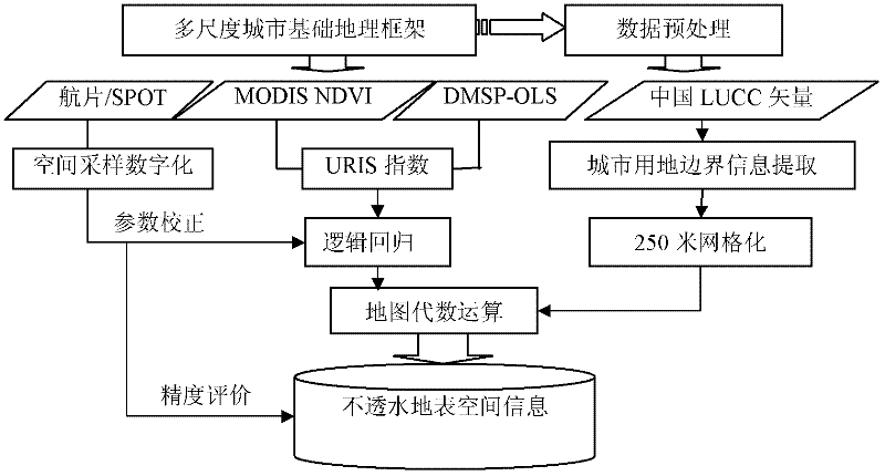
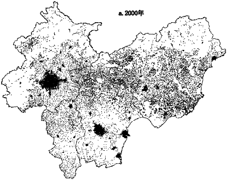
[0024] The remote sensing information extraction experiment of impervious surface was carried out in the Beijing-Tianjin-Tangzhou urban agglomeration, and the impervious surface index of urban and rural construction land was obtained according to the MODIS NDVI and DMSP-OLS remote sensing information. Furthermore, it embeds the high-precision spatial information of urban and rural construction land interpreted by manual digitalization, and realizes the extraction of impervious surface information of urban and rural construction land that is dynamically updated at the same time as China's land use / coverage data. figure 1 ,Specific steps are as follows:

[0025] (1) With the support of GIS, establish a 1:100,000 control network of the Beijing-Tianjin-Tangzhou urban agglomeration and a 250m spatial grid c...


PUM


Abstract

The invention provides a multi-scale impervious surface information remote sensing collaborative inversion method. In the method, a sampling information application regression model is acquired by virtue of a high-resolution remote sensing image, and information embedding of lands for urban and rural construction is acquired by the high resolution, so that information of relatively low resolution remote sensing image inversion is improved, multi-scale collaborative inversion of the impervious surface remote sensing information is realized, and the impervious surface remote sensing inversion accuracy is effectively improved. The method comprises the following steps of: performing space registration of multi-scale remote sensing information; embedding multi-source information of impervious surface; and performing multi-scale regressive and collaborative inversion to the impervious surface. The method can be used for effectively improving the precision of impervious surface space information remote sensing inversion, and has important application value to urban planning management and urban ecological environmental quality evaluation.

Description

technical field [0001] The invention belongs to the field of remote sensing information technology applied in the urban planning industry, and is suitable for application in urban land use planning and urban environment planning. Background technique [0002] Since the reform and opening up, China has experienced rapid urban growth. With the acceleration of urbanization and the increase of urban impermeable area, the phenomenon of urban rainstorm and waterlogging has occurred frequently in recent years. Because most of the surface is covered with impermeable concrete and asphalt, it is difficult to absorb the accumulated water on the ground surface, so that the rainwater cannot directly infiltrate the ground from the surface, increasing the surface runoff, resulting in a large amount of accumulated water, causing serious traffic jams, and damaging urban properties. The loss had a serious impact, and even casualties occurred. For example, in 2011, there were many serious ur...

Claims


Application Information

Patent Timeline
IPC IPC(8): G01S17/89
Inventor 匡文慧
Owner INST OF GEOGRAPHICAL SCI & NATURAL RESOURCE RES CAS
Learn More