Forecasting method and device of ionospheric delay of satellite navigation

An ionospheric delay and satellite navigation technology, which is applied in the field of satellite navigation ionospheric delay prediction, can solve the problems of reduced correction accuracy, complex calculation process, and difficulty in implementation, and achieves the effect of good prediction effect, simple calculation process, and easy implementation.

Inactive Publication Date: 2012-06-27
BEIHANG UNIV
View PDF2 Cites 11 Cited by
  • Summary
  • Abstract
  • Description
  • Claims
  • Application Information

AI Technical Summary

Problems solved by technology

[0008] However, the disadvantage of this method is that the Klobuchar model can only correct 50% to 60% of the influence of the ionosphere, and a better correction effect can be obtained when the ionosphere is in a stable state in mid-latitude regions. On the contrary, when there are serious ionosphere disturbances, Especially in the high and low latitudes of the equator, the processing effect is not good
[0011] However, the disadvantage of this method is that the prediction effect on the ionospheric delay is not good, and the calculation process is complicated, so it is not easy to realize
[0014] However, the disadvantages of this method are: the correction accuracy in the low-latitude regions during the ionospheric calm period and the magnetic storm period is significantly reduced, the grid point interpolation algorithm is diverse, and the calculation process is complicated, which is not easy to implement

Method used


Image

  • Forecasting method and device of ionospheric delay of satellite navigation
  • Forecasting method and device of ionospheric delay of satellite navigation
  • Forecasting method and device of ionospheric delay of satellite navigation

Examples


Embodiment Construction

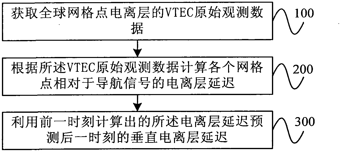
[0030] figure 1 It is a flowchart of an embodiment of a method for predicting satellite navigation ionospheric delay according to the present invention, as shown in the figure, including the following steps:

[0031] Step 100, acquiring raw VTEC observation data of the ionosphere at global grid points.

[0032] Specifically, the VTEC observation data file in IONEX format can be downloaded from the IGS website first; then the original VTEC observation data can be extracted from the VTEC observation data file. Among them, IGS refers to the international GNSS service organization, GNSS refers to the Global Navigation Satellite System (Global Navigation Satellite System), and the IONEX format refers to the ionospheric map exchange format (Ionosphere MapExchange Format).

[0033] In the VTEC original observation data, the division rules of grid points are as follows: latitude is from 87.5° to -87.5°, negative sign represents south latitude, and latitude interval is 2.5°; longitude...


PUM


Abstract

The invention provides a forecasting method and a device of ionospheric delay of satellite navigation. The method comprises the following steps of: obtaining VTEC (Vertical Total Electron Content) original observation data of ionospheres of global grid points; according to the VTEC original observation data, calculating ionospheric delay of each grid point relative to a navigation signal; and utilizing the calculated ionospheric delay in a former moment to forecast vertical ionospheric delay in a later moment. According to the method, forecast for the ionospheric delay is effectively realized, and a better forecasting effect is obtained. The calculation process is simple and is easily realized, and the method provides a new idea for forecasting the ionospheric delay.

Description

technical field [0001] The invention relates to a method and device for predicting ionospheric delay of satellite navigation, belonging to the technical field of satellite navigation. Background technique [0002] Satellite navigation system is a technology that uses satellites to achieve high-precision navigation and positioning. Existing satellite navigation systems include, for example, the Global Positioning System (Global Positioning System, GPS for short) of the United States and the Beidou satellite navigation system being developed in my country. In practical applications, the ionospheric delay error is the main error source that affects the ranging and positioning accuracy of the satellite navigation system. In order to improve the positioning accuracy, it is necessary to predict the ionospheric delay error. [0003] The ionosphere is a gaseous ionized region containing free electrons and ions at a height of 50-1000 km from the earth's surface. The delay of satel...

Claims


Application Information

Patent Timeline
Patent Type & Authority Applications(China)
IPC IPC(8): G01S19/07
Inventor 李锐白羽覃贝贝
Owner BEIHANG UNIV
Why Eureka
Try Eureka