Polygonal rasterisation parallel conversion method based on scanning line method

A conversion method and polygon technology, applied in special data processing applications, instruments, electrical digital data processing, etc., can solve the problems of long running time and low efficiency of vector data, and achieve the effect of shortening time, narrowing scanning range and improving efficiency.

Inactive Publication Date: 2012-07-04
NANJING UNIV
View PDF3 Cites 31 Cited by
  • Summary
  • Abstract
  • Description
  • Claims
  • Application Information

AI Technical Summary

Problems solved by technology

[0006] As mentioned above, from the perspective of data requirements, the conversion of vector data to raster data is the basic problem that GIS has been studying; from the perspective of software and hardware, the new hardware architecture of parallel computing clusters and multi-core processors that are gradually popularized needs to be effective. Utilization; Most importantly, in terms of efficiency, the rasterization operation time of massive vector data is too long, and the problem of low efficiency, the present invention provides a polygonal rasterization parallel conversion method based on the scan line method, the method adopts data Parallel strategy, which divides the vector polygons to be processed according to the number of processes, and then distributes them to each process, and each process rasterizes the polygons at the same time

Method used


Image

  • Polygonal rasterisation parallel conversion method based on scanning line method
  • Polygonal rasterisation parallel conversion method based on scanning line method
  • Polygonal rasterisation parallel conversion method based on scanning line method

Examples


Embodiment 1

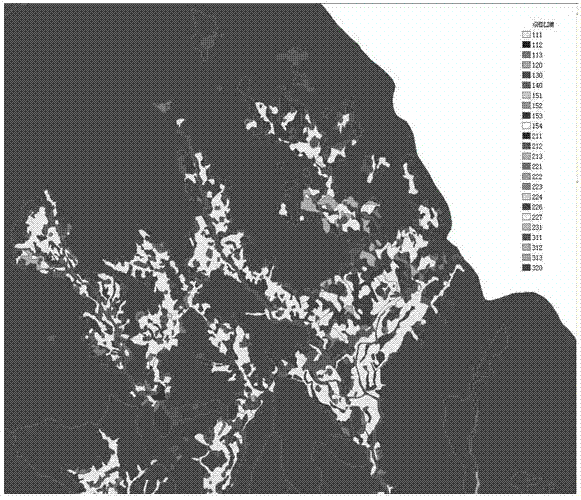
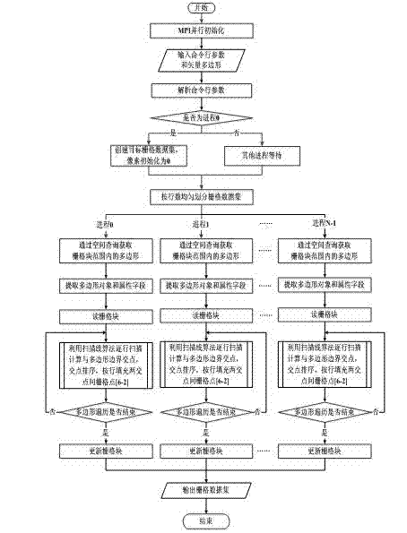
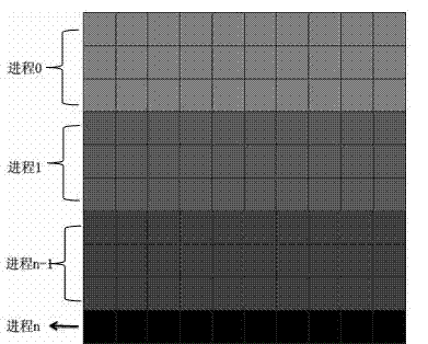
[0045] In this embodiment, the specified source data is the land status survey data of Changsha City, China, and the regional scope is 111.877 degrees west longitude, 114.256 degrees east longitude, 27.836 degrees south latitude, and 28.666 degrees north latitude; the total area of ​​the region is 11819.46 square kilometers. The data format is ESRI shapefile format, the total number of spots is 692177, and the data volume is 938MB. The spatial reference system of the data is the 1980 Xi'an coordinate system. Partial picture such as figure 1 shown. This embodiment is specifically implemented according to figure 2 The technical route shown, using as image 3 The data parallel strategy shown is developed under the Microsoft Visual Studio 2008 development platform using the standard C++ programming language, and implemented in the MPI parallel environment. The read and write operations of vector and raster data are realized through the open source geographic data format conve...


PUM


Abstract

The invention discloses a polygonal rasterisation parallel conversion method based on a scanning line method, belonging to the field of a geographic information system. The polygonal rasterisation parallel conversion method comprises inputting a command line parameter; carrying out MPI (Message Passing Interface) parallel initialization so as to obtain a total progress number and a current progress number; adopting an equal parallel mode, analyzing the command line parameter in each progress respectively, collecting parameter values behind a leading indicator respectively, reading a vector data source by using an OGROpen method, and judging whether the progress is the No.0 progress; adopting a data parallel strategy, dividing a raster data set vector polygon to be distributed to all progresses, and carrying out rasterisation of a polygon in each progress at the same time; writing the raster data, updating a raster block in each progress and outputting the converted raster data. The method is utilized to perform polygonal rasterisation of large amount of data to achieve relatively high efficiency and a satisfying conversion result, the conversion processing speed of a multi-core / multiprocessor of a high performance server to polygonal rasterisation is improved sufficiently, and the conversion time of polygonal rasterisation is shortened greatly.

Description

technical field [0001] The invention relates to a rasterization method of vector data, in particular to a polygonal rasterization parallel conversion method based on a scanning line method. Background technique [0002] Geographic Information System (GIS) is a computer service system based on spatial data, which acquires, expresses, processes, manages, analyzes and displays spatial data and serves geographic research and geographic decision-making. Spatial data usually has two forms: vector data (Vector Data) and raster data (Raster Data). Vector data represents geographic entities such as points, lines, and polygons by recording coordinates. The position of natural geographic entities is defined by their spatial position in the coordinate reference system. The coordinate space is set to be continuous, and its characteristic is that the positioning is obvious. , the property implies. The raster data is also called grid data (grid cell), which divides the plane into m×n pix...

Claims


Application Information

Patent Timeline
Patent Type & Authority Applications(China)
IPC IPC(8): G06F17/30
Inventor 陈振杰张帅李飞雪王亚飞李满春蒲英霞王加胜程亮
Owner NANJING UNIV
Why Eureka
Try Eureka