Driving perception navigation system

A navigation system and vehicle technology, applied in the field of vehicle perception navigation, can solve the problems of scattered layout, inconvenient management, and a large number of trunk amplifiers, and achieve the effect of improving efficiency, more functions, and enriching data sources.

Active Publication Date: 2014-09-17
TONGJI UNIV
View PDF2 Cites 0 Cited by
  • Summary
  • Abstract
  • Description
  • Claims
  • Application Information

AI Technical Summary

Problems solved by technology

[0007] The purpose of the present invention is to provide a driving perception navigation system to solve the problems in the prior art that due to the large number of trunk amplifiers and scattered layout, the difficulty of centralized monitoring and power supply, and the inconvenience of management

Method used


Image

  • Driving perception navigation system
  • Driving perception navigation system
  • Driving perception navigation system

Examples


example 1

[0051] Example 1. Neighborhood Dynamic Traffic Service Based on Vehicle Link

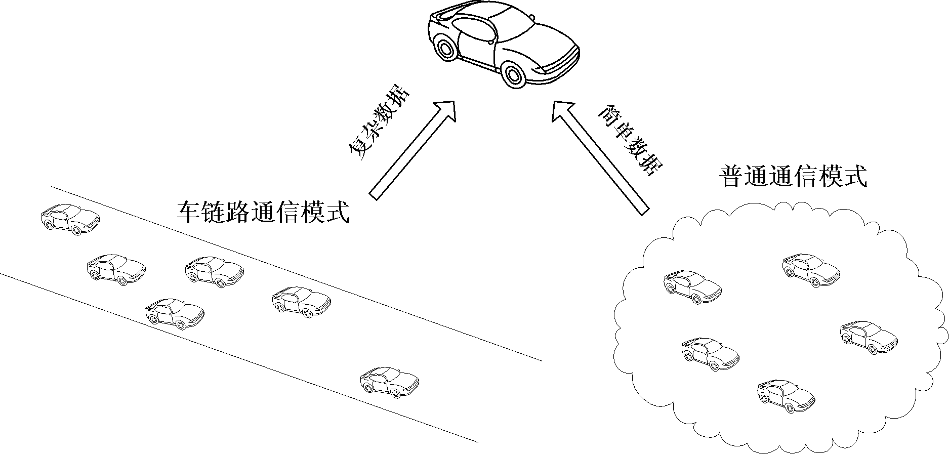
[0052] The vehicle node obtains the traffic flow status of the surrounding roads by obtaining the vehicle status information sent by the surrounding vehicles. The vehicle nodes in the vehicle chain will forward the received vehicle data in the vehicle chain to other vehicles, so as to achieve the role of sharing information.

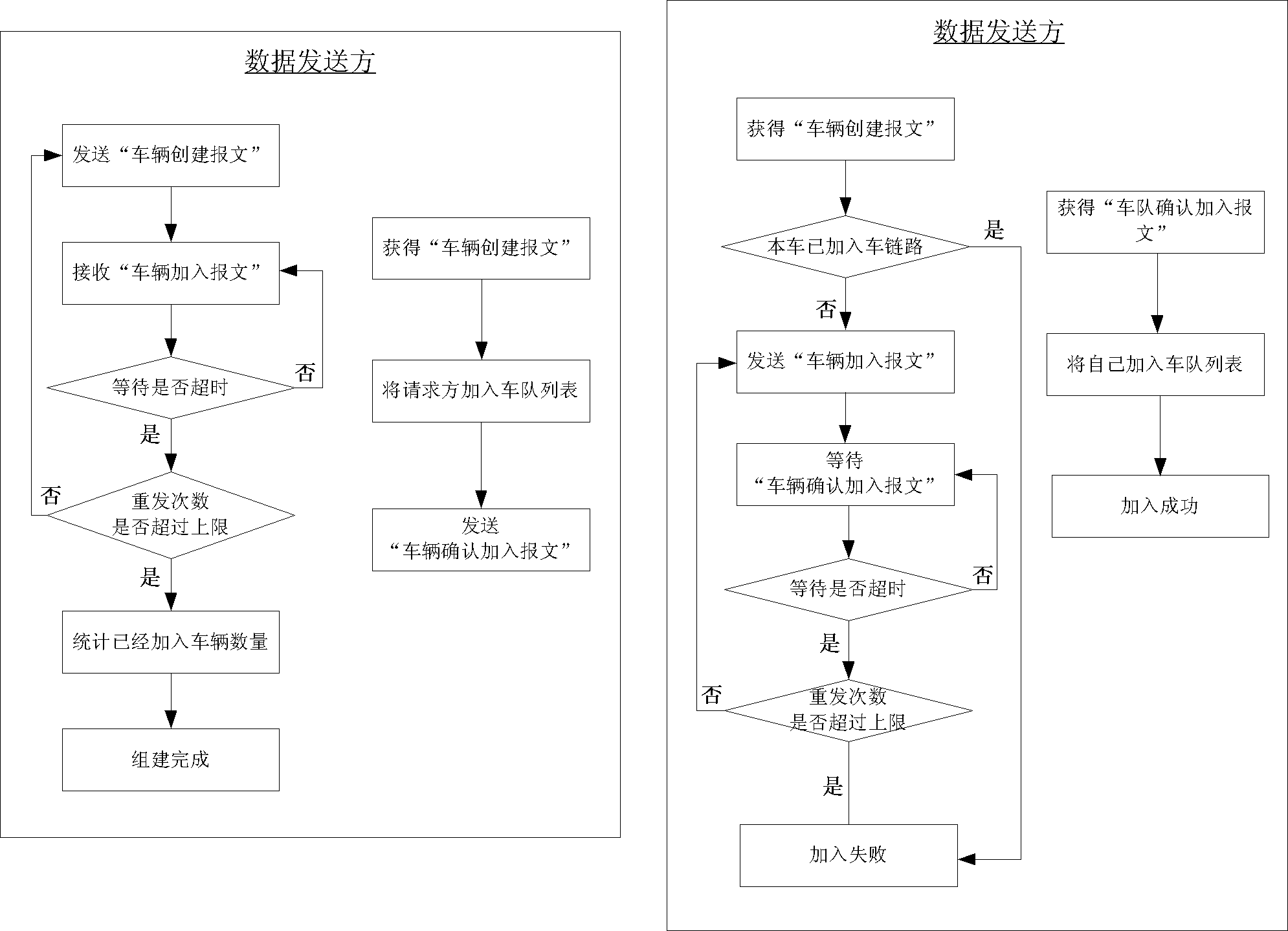
[0053] see Figure 4 , which shows the flow diagram of vehicle nodes sending and receiving data. The format of the data message is as follows: [Lab: PkgType: UID: Lat: Lng: Dir: Spd: Dis: QID: Tsend], the parameters of each field Definitions are as shown in Table 1 above.

[0054] Such as Figure 4 As shown, for the data sender: after the sending time arrives, the basic vehicle data will be regularly multicast to neighboring vehicles, such information includes the vehicle's GPS information (longitude and latitude), vehicle speed, driving direction and other information . ...

example 2

[0057] Example 2. Traffic event notification service based on vehicle link

[0058]The traffic event notification service is to notify the user in advance via the vehicle ad hoc network of information collected by vehicle sensors or information obtained from roadside infrastructure, such as event information such as vehicle breakdowns and traffic accidents.

[0059] The format of the data message transmitted by the event notification service is as follows: [Lab: Lat: Lng: Dis: Type: Description], where the field parameter Type is the type of event, which is divided into emergency events (such as breakdown, rear-end collision, bumping into people, etc.) and For non-emergency events (such as road congestion, road bans, etc.), Description is the specific content of the event, including the description information provided by the sender.

[0060] After each vehicle forms an on-vehicle ad hoc network based on vehicle link, the traffic event notification service can be divided into ...

example 3

[0064] Example 3. Traffic environment video information distribution service based on vehicle link

[0065] In special traffic scenarios, vehicle users need to know the traffic environment in a certain area, and video information is the best way to express it. The video information service process is as follows: Figure 5 shown.

[0066] Such as Figure 5 As shown, for the data sender: the system encodes and compresses each frame of video information before sending it.

[0067] For the data receiver: each time a frame of video information is received, it is first to check whether the frame data has been obtained, or a newer frame data has arrived, if it is directly discarded, otherwise it will be processed. Before processing, first judge whether the frame is the data of the vehicle chain. For the data of the vehicle chain, it must be forwarded first, so that the data in the fleet can reach all vehicles through multiple hops, and finally the data Stored in the cache.

[00...


PUM


Abstract

The invention provides a driving perception navigation system, which comprises a plurality of vehicles capable of forming an ad hoc network. The vehicles establish a first communication mode and a second communication mode according to the type and application of data to be transmitted. In the first communication mode, single-hop data transmission is adopted; and in the second communication mode, multi-hop data transmission is adopted. Compared with the prior art, the driving perception navigation system provides the two communication modes, and performs data transmission by adopting the two different communication modes for different data types and application, so that data can be quickly and reliably transmitted to all the vehicles using the driving perception navigation system, data transmission efficiency can be improved, and the vehicles on roads can be timely and accurately navigated.

Description

technical field [0001] The invention relates to a vehicle perception navigation technology, in particular to a driving perception navigation system using an ad hoc network. Background technique [0002] The development of the automobile industry and the popularization of private cars have brought about increasingly serious traffic problems and a sharp increase in traffic accidents. The traditional centralized intelligent transportation system has become an embarrassing task. First of all, the traffic data of the traditional centralized intelligent transportation system is simplified and limited. The current traffic information mainly collects macroscopic information of road traffic conditions through video and microwave collection methods on the road. , and cannot accurately perceive the status and conditions inside each vehicle; in addition, in the centralized intelligent transportation system, the communication between the vehicle and the monitoring center (central server)...

Claims


Application Information

Patent Timeline
Patent Type & Authority Patents(China)
IPC IPC(8): H04L29/08H04W4/04H04W84/18
Inventor 蒋昌俊陈闳中闫春钢方钰罗皓杰张栋良白星振
Owner TONGJI UNIV
Why Eureka
Try Eureka