Vehicle optimal-path navigation method based on vehicle internet

A technology of optimal route and navigation method, applied in the field of intelligent transportation system, can solve the problems of high implementation cost, complex structure, large hardware investment, etc.

Inactive Publication Date: 2012-10-03
BEIJING INSTITUTE OF TECHNOLOGYGY
View PDF6 Cites 30 Cited by
  • Summary
  • Abstract
  • Description
  • Claims
  • Application Information

AI Technical Summary

Problems solved by technology

The acquisition of real-time traffic information required by this type of method is very difficult, has high hardware requirements, high implementation costs, and the navigation accuracy is directly proportional to the geometric progression of the cost.
For example, the system described in the invention patent "An Intelligent Traffic Monitoring and Driving Real-time Navigation System" (CN1783162A) uses Doppler det

Method used


Image

  • Vehicle optimal-path navigation method based on vehicle internet
  • Vehicle optimal-path navigation method based on vehicle internet
  • Vehicle optimal-path navigation method based on vehicle internet

Examples


Embodiment Construction

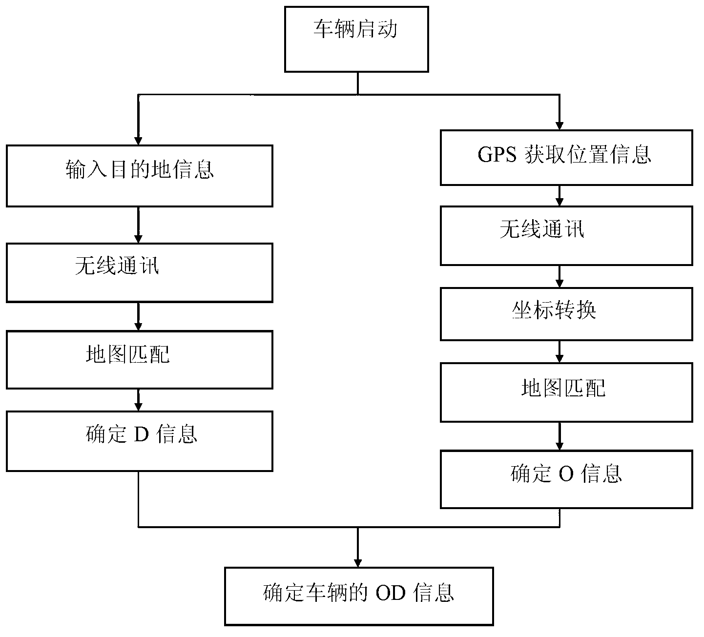
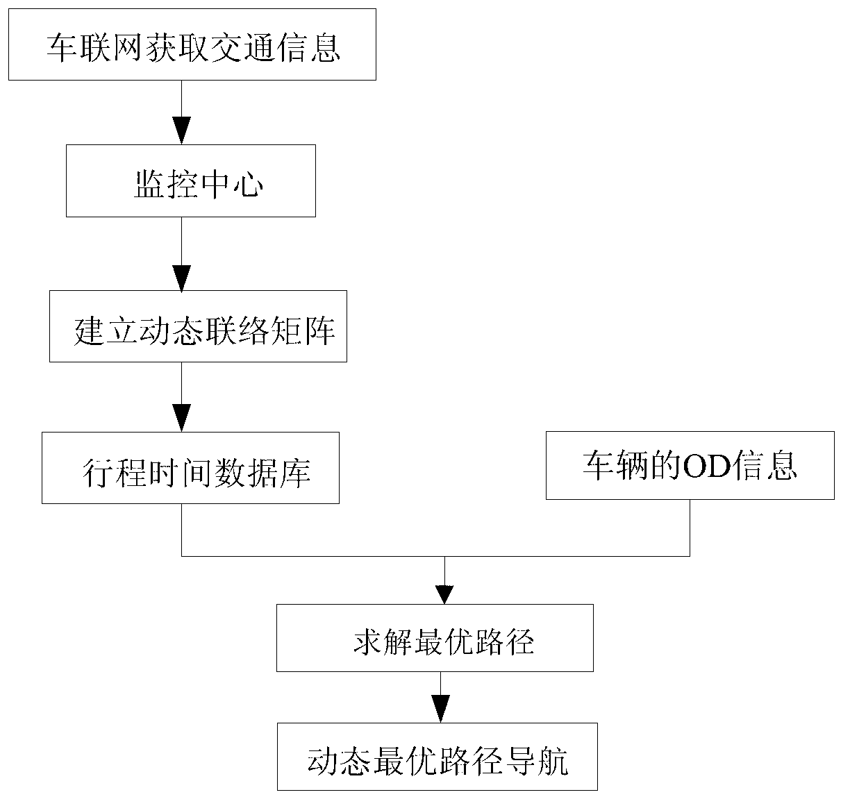
[0048] Concrete implementation process of the present invention comprises following 3 aspects:

[0049] ① Obtain the start-end information (OD information) of the vehicle;

[0050] ②Establish a dynamic contact matrix;

[0051] ③Solve the optimal route for each vehicle and implement traffic navigation.

[0052] ①

[0053] The following first combine as figure 1 The process shown in , describes the acquisition of OD information.

[0054] When the vehicle starts on the road network, its on-board GPS system automatically obtains the initial position information, and sends the information to the traffic monitoring center through the 3G wireless communication network. Since the common vehicle-mounted GPS system is based on the NMEA0183 protocol when determining the initial position of the vehicle, the initial position information it obtains is information in the WGS-84 coordinate system. Electronic maps in my country generally use the BJ-54 coordinate system, so After the vehic...


PUM


Abstract

The invention discloses a vehicle optimal-path navigation method based on vehicle internet. The vehicle optimal-path navigation method can be used to obtain determined and real-time OD (Origin Destination) information for replacing the original OD information obtained through estimation, so that the calculation of an optimal path is simpler and more reliable. According to the method, a dynamic connection matrix is arranged for marking the connection state of a road network; and a traffic monitoring center solves the optical driving path of a vehicle in the road network by using an improved ant colony algorithm according to the OD information and the dynamic connection matrix, so that the vehicle can respond to the accidents in real time and the purposes of increasing the navigation accuracy and improving the operation efficiency of the vehicle are achieved.

Description

technical field [0001] The invention relates to the field of intelligent transportation systems, in particular to a vehicle optimal route navigation method based on the Internet of Vehicles. Background technique [0002] In the past ten years, with the continuous improvement of national economic development and people's living standards, the number of vehicles on urban roads has increased rapidly, which has brought great pressure to the relatively lagging urban traffic construction. According to statistics, the annual economic losses caused by traffic jams in 39 cities in the United States are about 41 billion US dollars. Traffic congestion has become an urgent problem to be solved in large and medium-sized cities. Intelligent Transportation System (ITS) is a relatively effective solution, which effectively applies advanced information technology, network technology, automatic control technology and computer technology to the entire traffic management system, which can impr...

Claims


Application Information

Patent Timeline
IPC IPC(8): G08G1/0969
Inventor 黄若张威力刘浩明
Owner BEIJING INSTITUTE OF TECHNOLOGYGY
Why Eureka
Try Eureka