Object-oriented remote sensing inversion method of leaf area index of crop

A leaf area index, object-oriented technology, applied in the field of agricultural information, can solve the problems of low reliability of growth diagnosis and prescription map, interpolation processing error, etc.

Active Publication Date: 2012-12-19
BEIJING RES CENT FOR INFORMATION TECH & AGRI
View PDF0 Cites 41 Cited by
  • Summary
  • Abstract
  • Description
  • Claims
  • Application Information

AI Technical Summary

Problems solved by technology

Therefore, interpolation processing will bring certain errors; moreover, the reliability of growth diagnosis and prescription maps relying solely on LAI is not high, mainly because LA

Method used


Image

  • Object-oriented remote sensing inversion method of leaf area index of crop
  • Object-oriented remote sensing inversion method of leaf area index of crop
  • Object-oriented remote sensing inversion method of leaf area index of crop

Examples


Embodiment Construction

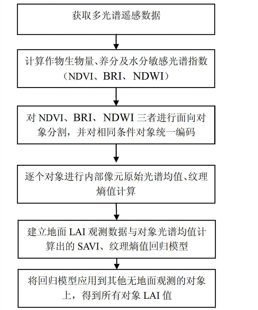
[0039] The specific implementation manners of the present invention will be further described in detail below in conjunction with the accompanying drawings and embodiments. The following examples are used to illustrate the present invention, but are not intended to limit the scope of the present invention.

[0040] figure 1 It is the main flow chart of the technical solution of the present invention. like figure 1 As shown, the object-oriented crop LAI inversion method proposed by the present invention comprises the following steps:

[0041] (1) Obtain multi-spectral remote sensing data, which contains reflectance data of the following four bands: blue band (Rblue), wavelength range is 0.45-0.52 microns; green band (Rgreen), wavelength range is 0.52-0.60 microns; red band (Rred), the wavelength range is 0.63-0.69 microns; the near-infrared band (Rnir), the wavelength range is 0.76-0.90 microns. At the same time, the ground observation LAI data is obtained, and the differen...


PUM


Abstract

The invention discloses an object-oriented remote sensing inversion method of a leaf area index of a crop, comprising the following steps of: acquiring multispectral remote sensing data; calculating a biomass spectral index NDVI (Normalized Difference Vegetation Index), a crop nutrient spectral index BRI and a water sensitive spectral index NDWI (Normalized Difference Water Index) of a crop colony by utilizing the acquired multispectral remote sensing data; carrying out object-oriented segmentation and encoding according to the biomass spectral index NDVI, the crop nutrient spectral index BRI and the water sensitive spectral index NDWI of the crop colony by utilizing a mean shift algorithm; sequentially carrying out the original spectral mean calculation of pixels on objects according to an encoding sequence to obtain a spectral index SAVI (Soil-Adjusted Vegetation Index) sensitive to the LAI (Leaf Area Index), and carrying out texture structure calculation; building a regression model of ground LAI observation data, the spectral index SAVI sensitive to the LAI and the texture structure calculation; and carrying out inversion calculation on the object without the ground LAI observation data by utilizing the regression model to obtain the LAI of the object without the ground LAI observation data.

Description

technical field [0001] The invention relates to the technical field of agricultural information, in particular to an object-oriented remote sensing inversion method of crop leaf area index. Background technique [0002] The use of remote sensing technology for large-scale crop leaf area index (LAI, Leaf area index) inversion has become a relatively mature technical means and method. It mainly uses multi-spectral remote sensing to screen out the sensitive bands of LAI, and then uses the sensitive bands to calculate the spectral index. Then use the measured LAI data and spectral index to build a model, and then apply the model to the spectral index corresponding to other pixels to obtain the LAI of all pixels in the corresponding area of ​​the complete image. It can be seen that the inversion calculation of LAI is performed pixel by pixel, and the calculation efficiency is relatively low when inverting large-scale LAI or multiple time-phase LAI. For crops, due to the same loc...

Claims


Application Information

Patent Timeline
IPC IPC(8): G01B11/28G06F19/00
Inventor 杨贵军赵春江冯海宽宋晓宇顾晓鹤杨小冬徐新刚李存军杨浩陈红
Owner BEIJING RES CENT FOR INFORMATION TECH & AGRI
Why Eureka
Try Eureka