Method for implementing in-orbit maneuvering imaging task of agile earth observing satellite

A mobile imaging and mission technology, applied in the direction of three-dimensional position/course control, etc., can solve the problems of inability to save and realize reliable and continuous operation of satellite imaging tasks, so as to ensure reliability and continuity, and enhance satellites to respond to on-orbit emergency tasks and the ability to change state, reduce the effect of dependence

Active Publication Date: 2013-01-09
AEROSPACE DONGFANGHONG SATELLITE
View PDF6 Cites 34 Cited by
  • Summary
  • Abstract
  • Description
  • Claims
  • Application Information

AI Technical Summary

Problems solved by technology

Clearly, the command-level method of operation of previous models cannot achieve this
In addition, the previous models cannot save the instructions that have been registered on the ground after the on-board computer is reset or switched off, and must rely on the ground to re-register. At this time, reliable and continuous operation of satellite imaging tasks cannot be achieved.

Method used


Image

  • Method for implementing in-orbit maneuvering imaging task of agile earth observing satellite
  • Method for implementing in-orbit maneuvering imaging task of agile earth observing satellite
  • Method for implementing in-orbit maneuvering imaging task of agile earth observing satellite

Examples


Embodiment Construction

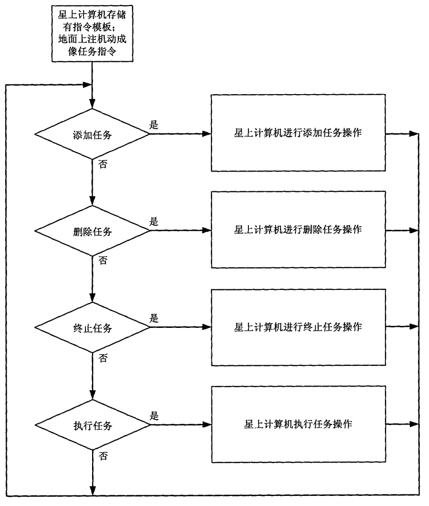
[0028] Below in conjunction with accompanying drawing and specific embodiment the present invention is described in further detail:

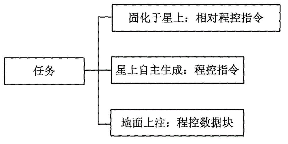
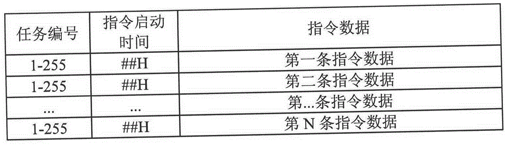
[0029] Such as figure 1 As shown, the agile satellite maneuvering imaging task includes: relative program-controlled command, program-controlled command and program-controlled data block. The program-controlled command refers to the command sent according to the absolute time on the star, and the relative program-controlled command means that the sending time of all commands in a group of commands is based on the start time of the first command. In addition, according to the needs of the attitude control and data transmission subsystems, the program-controlled data block is designed on the basis of the program-controlled instructions of previous models. The command data content of the program-controlled data block is 32 bytes to make up for the problem that the program-controlled command has only 4 bytes of command data length, which causes ins...


PUM


Abstract

The invention discloses a method for implementing an in-orbit maneuvering imaging task of an agile earth observing satellite. Command parameters required for maneuvering imaging are transmitted to a satellite by a user through a satellite-ground link; the satellite can generate a command set automatically; an on-satellite computer stores commands by adopting a two-dimensional index data structure of a task number and time information and simultaneously is matched with a program control data block which is noted on the ground surface and is used for an agile maneuvering task; and the operation of adding task, deleting the tasks, operating the tasks and interrupting the tasks are realized according to the requirements of a ground user. In addition, the on-satellite computer can perform backup and storage on the commands relative to the tasks through an internal emergency data recovery module, and the commands can be recovered after the on-satellite computer is reset or shut down, so that the overall satellite continuously executes the tasks according to a predetermined mode. By the method, the application performance of the satellite can be improved greatly with low cost; moreover, the capability of dealing with in-orbit urgent tasks and state change of the satellite can be enhanced; the dependence on ground surface measurement and control is reduce; and the safety and the reliability are improved.

Description

technical field [0001] The invention relates to a method for realizing an agile satellite on-orbit mobile imaging task, and belongs to the technical field of agile satellite mobile imaging. Background technique [0002] The current model of satellites does not have any maneuvering actions when performing imaging tasks. The ground users turn on, take pictures, and shut down the camera subsystem on the satellite, and then download the data to the ground receiving station through the digital transmission subsystem. The program-controlled instructions executed in chronological order are coded and formatted according to the satellite-to-earth communication format, and are uploaded to the satellite when the satellite is in transit. After receiving it, the on-board computer sends instructions to the sub-systems on the star in order to complete imaging tasks. [0003] The high agility and high precision characteristics of agile satellites require the coordination of multiple subsys...

Claims


Application Information

Patent Timeline
Patent Type & Authority Applications(China)
IPC IPC(8): G05D1/10
Inventor 李超蒋轶颖李志刚赵键杨芳孙峻
Owner AEROSPACE DONGFANGHONG SATELLITE
Why Eureka
Try Eureka