High-resolution remote sensing data atmospheric correction method

A technology of remote sensing data and high resolution, applied in the field of remote sensing, can solve problems such as poor automation, high data requirements, and inability to obtain aerosol optical depth, and achieve the effect of improving accuracy and usability

Active Publication Date: 2013-03-06
REMOTE SENSING APPLIED INST CHINESE ACAD OF SCI
View PDF5 Cites 29 Cited by
  • Summary
  • Abstract
  • Description
  • Claims
  • Application Information

AI Technical Summary

Problems solved by technology

[0005] Disadvantage 1, the aerosol optical thickness of the entire image cannot be obtained;
[0006] Disadvantage 2. Some methods require images from multiple pe

Method used


Image

  • High-resolution remote sensing data atmospheric correction method
  • High-resolution remote sensing data atmospheric correction method
  • High-resolution remote sensing data atmospheric correction method

Examples


Embodiment Construction

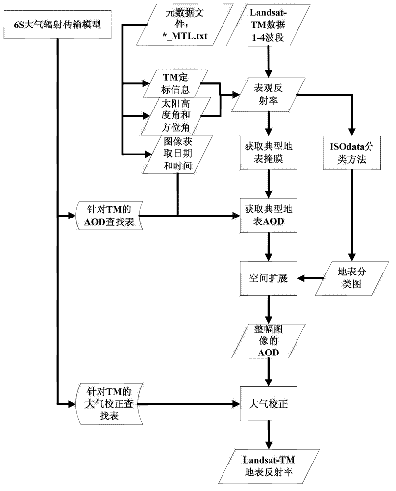
[0038] The specific implementation manners of the present invention will be further described in detail below in conjunction with the accompanying drawings and embodiments. The following examples are used to illustrate the present invention, but are not intended to limit the scope of the present invention.

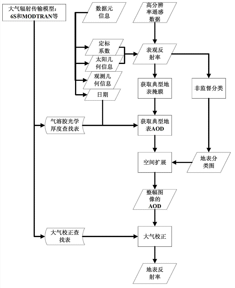
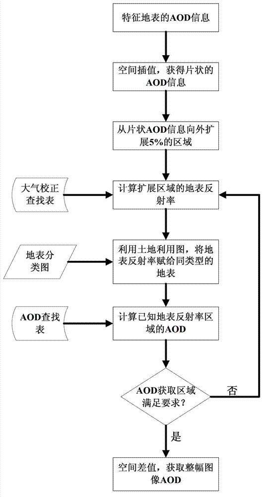
[0039] High-resolution remote sensing data refers to visible light and near-infrared satellite remote sensing data whose nominal spatial resolution is greater than or equal to 30 meters, including Landsat-TM / ETM+, HJ1A\B-CCD, CBERS-02B\CCD, ZY-3\MUX, GEOEYE -1 for multiband data. image 3 It is a flow chart of Landsat-TM data atmospheric correction of an embodiment of the present invention, comprising the following steps:

[0040] 1. Extract calibration information (calibration coefficient), solar geometric information (solar zenith angle and solar azimuth angle), observation geometric information (observation zenith angle and observation azimuth), data acquisition date ...


PUM


Abstract

The invention discloses a high-resolution remote sensing data atmospheric correction method comprising the following steps of: S1, obtaining related information from data element information; S2, calculating the apparent reflectance of the typical land surface; S3, obtaining a mask of the typical land surface; S4, building an AOD (Aerosol Optical Depth) inversion correction lookup table by utilizing an atmospheric radiation transmission model; S5, calculating the AOD of the typical land surface; S6, obtaining a land surface classification chart; S7, forming the AOD of an whole image through a spatial expansion method; and S8, executing atmospheric correction on the high-resolution remote sensing data according to the AOD of the whole image and the atmospheric correction lookup table to get the land surface reflectance of the high-resolution remote sensing data. In the method, the high-resolution satellite remote sensing data is used for obtaining the AOD of the whole image, the accuracy and usability of the atmospheric correction are improved, and automation of the whole flow from AOD to atmospheric correction is realized.

Description

technical field [0001] The invention relates to the technical field of remote sensing, in particular to an atmospheric correction method for high-resolution remote sensing data. Background technique [0002] The aerosol in the atmosphere is an intermediary substance between the ground and satellite sensors, which inevitably affects the data obtained by satellite remote sensing. As the aerosol increases, the quality of the obtained image will be greatly affected. In order to make full use of the surface information obtained by satellite remote sensing, we need to correct the information caused by the atmosphere in the image. Since the 1970s, scientists have carried out a lot of research on atmospheric correction of remote sensing data. At present, the atmospheric correction of remote sensing data is mainly divided into two categories: the atmospheric correction method based on the statistical information of the remote sensing image itself and the atmospheric correction metho...

Claims


Application Information

Patent Timeline
IPC IPC(8): G01S7/497G01S7/48
Inventor 仲波吴善龙柳钦火
Owner REMOTE SENSING APPLIED INST CHINESE ACAD OF SCI
Why Eureka
Try Eureka