Automatic registration method of aviation and ground LiDAR data based on building contour constraint

An automatic registration and building technology, applied in image data processing, instruments, radio wave measurement systems, etc., can solve problems to be studied, and achieve the effect of accuracy advantages, reliability advantages, and precise registration

Inactive Publication Date: 2013-04-03
NANJING UNIV
View PDF3 Cites 23 Cited by
  • Summary
  • Abstract
  • Description
  • Claims
  • Application Information

AI Technical Summary

Problems solved by technology

However, the research on this type of method is not mature enough at this stage, and there are still some problems in terms of stability, calculation amount, and degree of automation. How...

Method used


Image

  • Automatic registration method of aviation and ground LiDAR data based on building contour constraint
  • Automatic registration method of aviation and ground LiDAR data based on building contour constraint
  • Automatic registration method of aviation and ground LiDAR data based on building contour constraint

Examples


Embodiment Construction

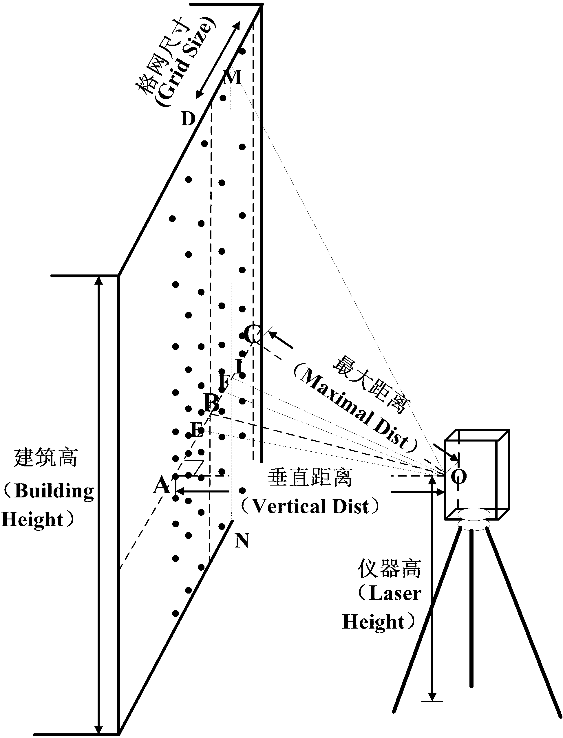
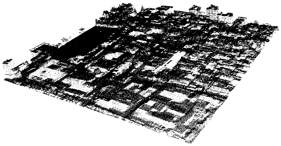
[0072] In this embodiment, the aviation LiDAR data PA={PA i , i=0,1,2,...,C A} as a benchmark, the ground LiDAR data PB obtained by Leica ScanStation2 scanning = {PB i , i=0,1,2,...,C B} registered to the aerial data. The average point spacing of aviation LiDAR data is 1m, the elevation accuracy is 15cm, the plane accuracy is 30cm, and the number of points is about 11 million (see Figure 2-a ); the ground LiDAR data is spliced ​​by the data of 9 stations through the target, the data accuracy is 20cm / 100m, and the number of points is about 30 million (see Figure 2-b ).

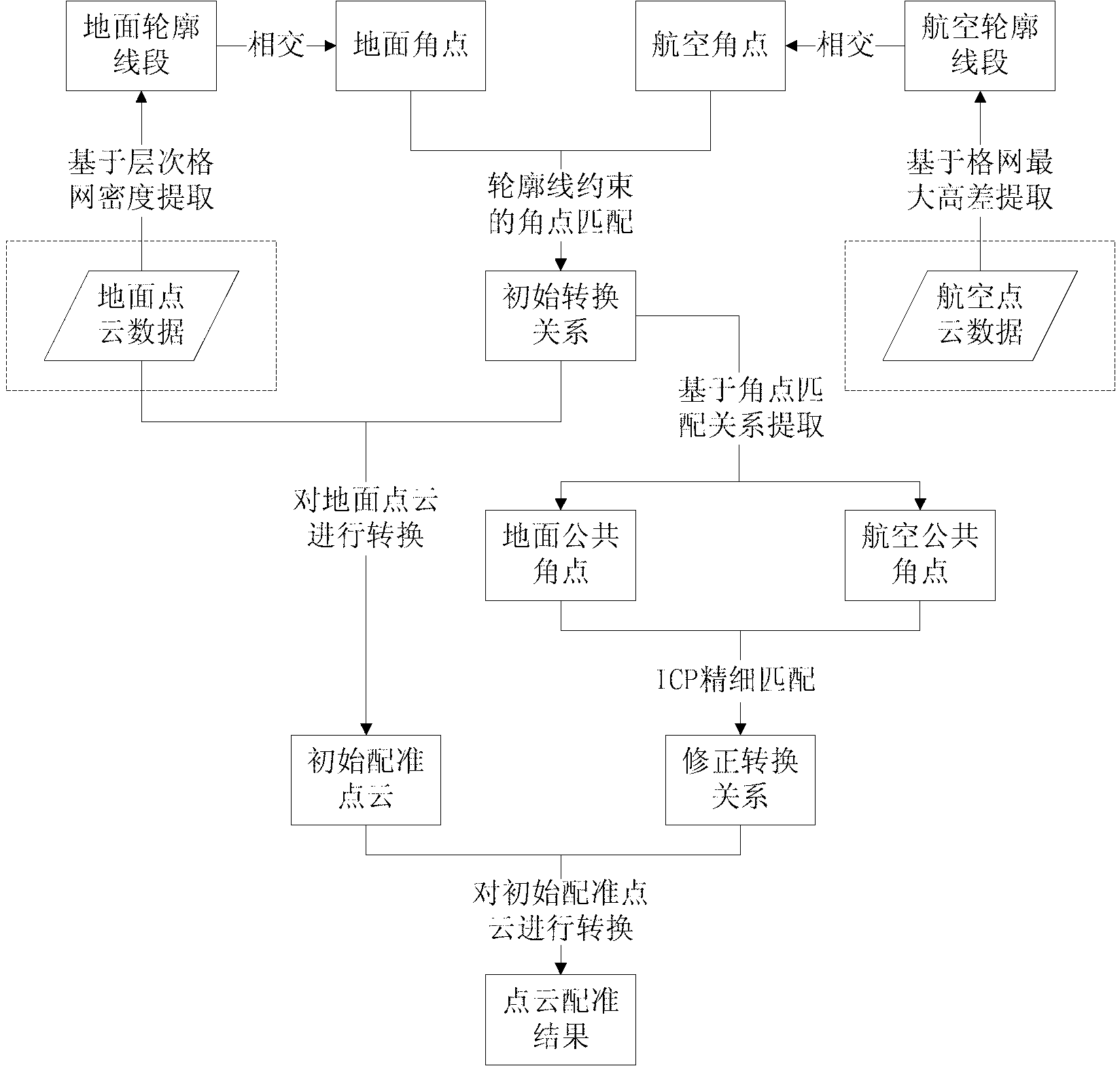
[0073] The embodiment of the present invention is based on the automatic registration method of aerial and ground LiDAR data based on building outline constraints (see the flow chart figure 1 ), including the following steps:

[0074] The first step is to extract the outline of the building - the outline of the building is extracted from the aerial LiDAR data, which is called the aerial outline; the out...


PUM


Abstract

Disclosed is an automatic registration method of aviation and ground LiDAR data based on building contour constraint. The method includes firstly extracting building contours or aviation contours and ground contours for short from aviation and ground LiDAR data; extracting building angular points or aviation angular points and ground angular points for short from the aviation contours and the ground contours; taking the matching degree between the aviation contours and the ground contours as constraint, calculating initial transfer matrixes between the aviation angular points and the ground angular points, and obtaining initial matching angle dot pairs; finally, calculating correction transfer matrixes between the initial matching angle dot pairs by using an iterative closest point (ICP) algorithm, and converting ground dot cloud data to be matched through the initial transfer matrixes and the correction transfer matrixes successively to achieve automatic high-precision registration of the aviation and ground LiDAR data. The method has great advantages in registration reliability and accuracy with contour lines serving as constraint; and simultaneously, based on LiDAR data to be matched and reference LiDAR data, accuracy registration between the aviation and ground LiDAR data can be achieved without other auxiliary data.

Description

technical field [0001] The invention relates to a registration method for aerial and ground LiDAR data, in particular to an automatic registration method for aerial and ground LiDAR data based on building outline constraints. Background technique [0002] At present, lidar technology (LiDAR) is developing vigorously. The lidar family includes aviation LiDAR, ground LiDAR, vehicle LiDAR, and indoor LiDAR. The performance of LiDAR varies from platform to platform, and the scope of application complements each other. With the continuous advancement of lidar technology, the fusion processing of lidar on multiple platforms has gradually become a trend. The most widely used lidars are aerial LiDAR and terrestrial LiDAR. Aerial LiDAR has a large scanning range and can obtain information on the top of objects. However, the phenomenon of point cloud banding is obvious, and the side information of ground objects is missing. Ground LiDAR can obtain detailed side information of ground...

Claims


Application Information

Patent Timeline
IPC IPC(8): G06T7/00G01S7/539
Inventor 程亮李满春钟礼山童礼华陈焱明陈振杰王亚飞马磊丁佳鹏谌颂
Owner NANJING UNIV
Why Eureka
Try Eureka