Ankle tracking system based on global position system (GPS)/ Beidou navigation satellite system

A Beidou navigation and tracking system technology, applied in the field of satellite communications, can solve the problems of lack of GPS/Beidou dual positioning, GPS insecurity, inability to directly obtain positioning data, etc., to achieve the effect of preventing escape

Inactive Publication Date: 2013-05-15
河北紫微星通无人机科技有限公司
View PDF4 Cites 12 Cited by
  • Summary
  • Abstract
  • Description
  • Claims
  • Application Information

AI Technical Summary

Problems solved by technology

[0003] At present, GPS satellite positioning technology has been widely used in road navigation, especially in vehicles. Generally, an antenna that can receive positioning satellite signals is installed on the vehicle, and an antenna that can convert positioning satellite signals into , latitude and height data host, also includes a mobile phone in the host, the mobile phone can send longitude, latitude and height data to the control center through short messages, the control center is a kind of longitude, latitude and height data Applied on the map, and the service staff notifies the payment agency of the user's current location through the mobile phone. It is known that the users who use the GPS positioning system are the objects to be tracked and notified, and the relevant positioning data cannot be obtained directly.
In view of this, GPS tracking ...

Method used


Image

  • Ankle tracking system based on global position system (GPS)/ Beidou navigation satellite system
  • Ankle tracking system based on global position system (GPS)/ Beidou navigation satellite system
  • Ankle tracking system based on global position system (GPS)/ Beidou navigation satellite system

Examples


Embodiment Construction

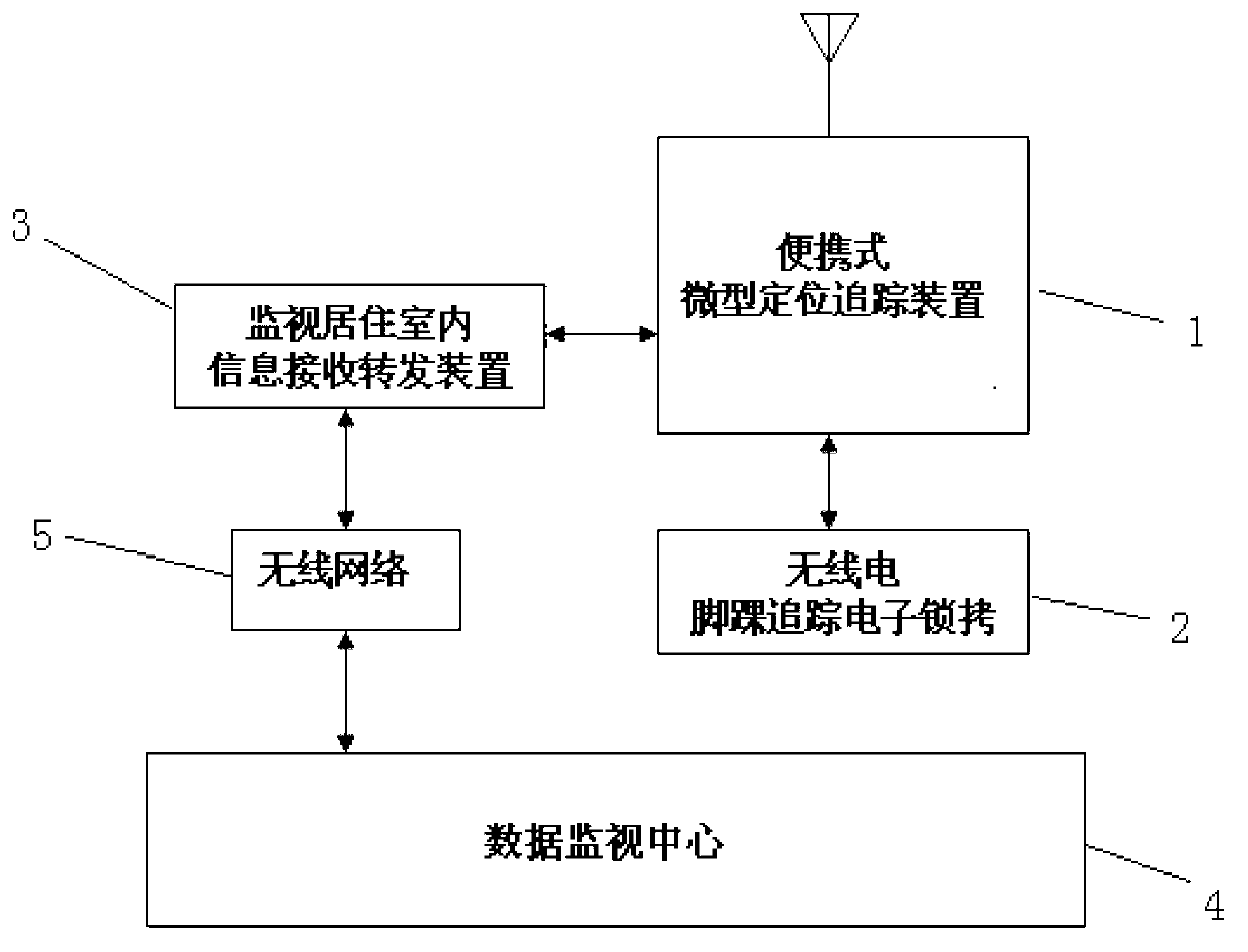
[0027] See figure 1 As well as 5 , For an ankle tracking system based on GPS / Beidou navigation, the system includes: portable micro -positioning tracking device 1 to be monitored to be carried on the body; radio ankle tracking electronic shackle 2 is forcibly worn by the monitor.On the ankle, relying on your own power cannot be removed, it is to prevent escape and hunting; monitoring indoor information receiving and forwarding device 3 is a device installed in the home residence of the person who receives surveillance.Data information, and use the wireless network 5 to forward it to the data surveillance center 4. The surveillance center is the judicial department monitoring the residential management system. In addition, the surveillance of the interior information receiving and forwarding device 3 also has a portable micro -positioning tracking device 1 charging and downloaded scope of the day.The function of limited data information.

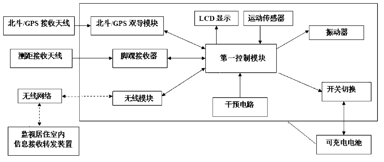
[0028] See figure 2 , Portable micro -posi...


PUM


Abstract

The invention provides an ankle tracking system based on a global position system (GPS)/ a Beidou navigation satellite system. The ankle tracking system based on the global position system (GPS)/ the Beidou navigation satellite system comprises a potable micro location tracking device, a wireless electric ankle tracking electronic lock cuff, a monitored living room message pick-up and transmit device and a data monitoring center, wherein the transmit device receives data information from the potable micro location tracking device and sends the data information for the data monitoring center through wireless network, and the wireless electric ankle tracking electronic lock cuff can communicate with the potable micro location tracking device. The ankle tracking system based on the global position system (GPS)/ the Beidou navigation satellite system is capable of monitoring information of a monitored person in real time, is used for preventing and tracking the monitored person due to the fact that the potable micro location tracking device and the wireless electric ankle tracking electronic lock cuff are resistant to strong damage and the monitored person can not get rid of the wireless electric ankle tracking electronic lock cuff on the feet. The potable micro location tracking device and the wireless electric ankle tracking electronic lock cuff are integrated into one, cooperate in working, waterproof, damage resistant and capable of working 1-2 years without changing batteries.

Description

Technical field [0001] The technology field of satellite communication involves an ankle tracking system, especially the ankle tracking system based on GPS / Beidou navigation. This system integrates navigation, positioning, and monitoring a variety of basic functions. [0002] Background technique [0003] At present, the GPS satellite positioning technology has been widely used in road navigation, especially on transportation, and is generally installed on the transportation of the transportation to receive a satellite signal.The host of latitude and height data also contains a mobile phone in the host. The mobile phone can transmit the meridians, latitude, and altitude data to the control center through short message.Apply on the map and by the service personnel to notify the user's current paid institution through the mobile phone, and the users who use the GPS positioning system are all tracked and informed objects, and cannot directly obtain relevant positioning data.In view ...

Claims


Application Information

Patent Timeline
IPC IPC(8): G01S19/39G01S19/42E05B75/00
Inventor 高爱军刘德生尤淑莉
Owner 河北紫微星通无人机科技有限公司
Why Eureka
Try Eureka