Airborne SAR (synthetic aperture radar) flying route arrangement method based on dynamic wind speed and direction adjustment

A technology of dynamic adjustment, wind speed and wind direction, applied in imaging systems, remote sensing, and observation fields, can solve problems such as incapability of imaging, insurmountability, and inability to work, and achieve the effects of improving imaging effects, improving imaging effects, and eliminating the impact of imaging

Active Publication Date: 2013-06-26
BEIHANG UNIV
View PDF5 Cites 4 Cited by
  • Summary
  • Abstract
  • Description
  • Claims
  • Application Information

AI Technical Summary

Problems solved by technology

If the drift angle exceeds the azimuth working range of the stable platform of the SAR system, it is difficult for the SAR system to work normally, or even unable to image
[0007] For the influence of crosswind on the imaging effect of airborne SAR system, traditional methods can only overcome the influence of accurately forecasted wind or small constant wind, and for wind that cannot be accurately forecasted or relatively large wind, the The effects of random disturbances are often insurmountable
At the same time, the traditional method often cannot adjust the flight of the carrier aircraft in real time according to the actual wind speed and direction. The flight state of the carrier aircraft will not be able to meet the imaging requirements of the SAR system, and the SAR system may not be able to image normally, or even fail to work

Method used


Image

  • Airborne SAR (synthetic aperture radar) flying route arrangement method based on dynamic wind speed and direction adjustment
  • Airborne SAR (synthetic aperture radar) flying route arrangement method based on dynamic wind speed and direction adjustment
  • Airborne SAR (synthetic aperture radar) flying route arrangement method based on dynamic wind speed and direction adjustment

Examples


Embodiment

[0054] The method for real-time route adjustment based on the measured wind speed and direction provided by the present invention will be further described below through specific examples and data.

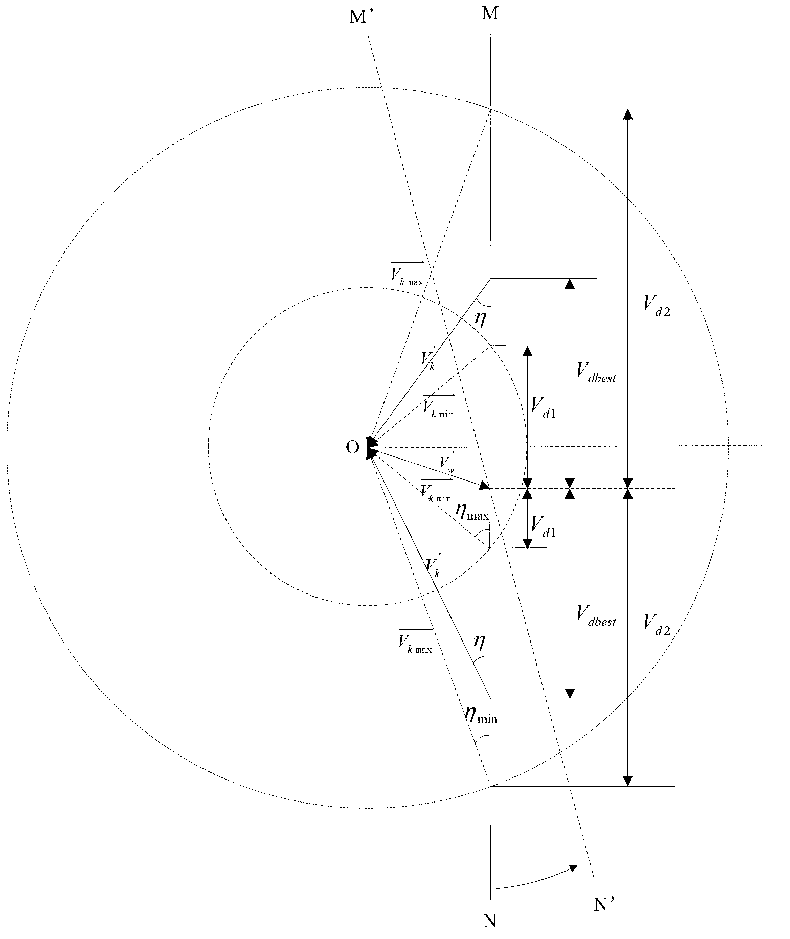
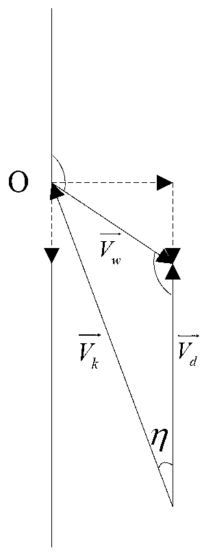
[0055] The present invention is applied to the imaging of an airborne SAR system of an unmanned aircraft. The azimuth working angle range of the SAR radar stabilization platform loaded on the unmanned aircraft is ±18°, and the flight height of a certain imaging task is 1500m. When there is no wind, ground speed is equal to air speed, i.e. Vd=Vk=60m / s, and the concrete steps of applying the inventive method are:

[0056] Step 1: Initialize the route of the carrier aircraft and the relevant parameters of the SAR system;

[0057] According to the imaging mission requirements of the UAV, initialize and set the route, the direction of the route is 0°, and start flying in parallel to the specified route area. The airspeed of the UAV is V k The minimum value of V kmin = 40m / s and maxim...


PUM


Abstract

The invention discloses an airborne SAR (synthetic aperture radar) flying route arrangement method based on dynamic wind speed and direction adjustment. Airspeed and route direction are adjusted in real time to improve SAR imaging effect. The method includes: initializing a route of an aerial carrier and related parameters of an SAR system, acquiring wind speed of the current aerial carrier flying at a certain height to execute a task according to actually measured ground speed and airspeed, and dynamically adjusting the airspeed and the route direction according to vector relation among the airspeed, the ground speed and the wind speed so that the aerial carrier obtains optimal ground speed and drift angle for imaging of the airborne SAR system. Operating angle range of the SAR system in the stable platform azimuth is satisfied, and the effect of wind disturbance on imaging of the airborne SAR system is eliminated. The effect of the aerial carrier responding to real-time change of upper wind upon imaging of the airborne SAR system is increased effectively, and imaging effect is improved effectively while the SAR hardware system is not complicated.

Description

technical field [0001] The present invention relates to remote sensing, observation, and imaging systems such as airborne SAR systems, and in particular to a carrier aircraft based on measured wind speed and direction SAR imaging, which adjusts the airspeed and route direction in real time and arranges routes to improve the imaging effect. method. Background technique [0002] Airborne synthetic aperture radar (Synthesis Aperture Radar, referred to as SAR) is an advanced active microwave remote sensor, which uses a small-aperture antenna that moves relative to the target and uses signal processing methods to obtain high-resolution coherent imaging. SAR is used on aircraft or space vehicles. It has the characteristics of wide observation area, fast information provision, clear images, and all-weather work. It can effectively identify camouflage and has penetrating identification capabilities. Therefore, it is widely used in military and civilian fields, such as : Disaster pr...

Claims


Application Information

Patent Timeline
Patent Type & Authority Applications(China)
IPC IPC(8): G05D1/10
Inventor 王宏伦刘畅郑丽丽向锦武
Owner BEIHANG UNIV
Why Eureka
Try Eureka