Method and device achieving underground mine positioning and navigation

A positioning navigation and positioning algorithm technology, which is applied to mining equipment, location information-based services, mining equipment, etc., can solve the problems of RFID missing reading, heavy-duty operations, and limited flexibility, and achieve high-precision wireless positioning and short-distance wireless Effects of communication and weight reduction

Inactive Publication Date: 2013-07-03
DANDONG DONGFANG MEASUREMENT&CONTROL TECHCO
View PDF4 Cites 34 Cited by
  • Summary
  • Abstract
  • Description
  • Claims
  • Application Information

AI Technical Summary

Problems solved by technology

The satellite positioning method needs to be visible to the satellite, which cannot be used in underground mines. Short-range wireless positioning methods such as RFID, ZIGBEE, WIFI, UWB, and NFC are currently widely used in underground mines. RFID, ZIGBEE, and WIFI, UWB, and NFC are all used. under development
At present, RSSI, TOA, TDOA and AOA are mostly used as the principle of short-distance wireless positioning. TOA and TDOA need accurate time synchronization and auxiliary facilities. AOA antenna technology is relatively complicated, and the low-cost and easy-to-implement method is RSSI principle or RFID method. Those who are at the level of regional positioning technology, the positioning accuracy is not high
There is a phenomenon of missed reading in RFID; using the positioning method of the RSSI principle, due to the propagation characteristics of the wireless signal, the positioned target may jump in an area, so that the positioning accuracy is not high
[0004] In addition, underground personnel positioning equipment, wireless voice communication equipment, lighting equipment, first aid equipment, etc. are mostly in a separate state. During operation, underground workers are covered with various equipment on their bodies, causing heavy work and limiting their flexibility.

Method used


Image

  • Method and device achieving underground mine positioning and navigation
  • Method and device achieving underground mine positioning and navigation
  • Method and device achieving underground mine positioning and navigation

Examples


Embodiment Construction

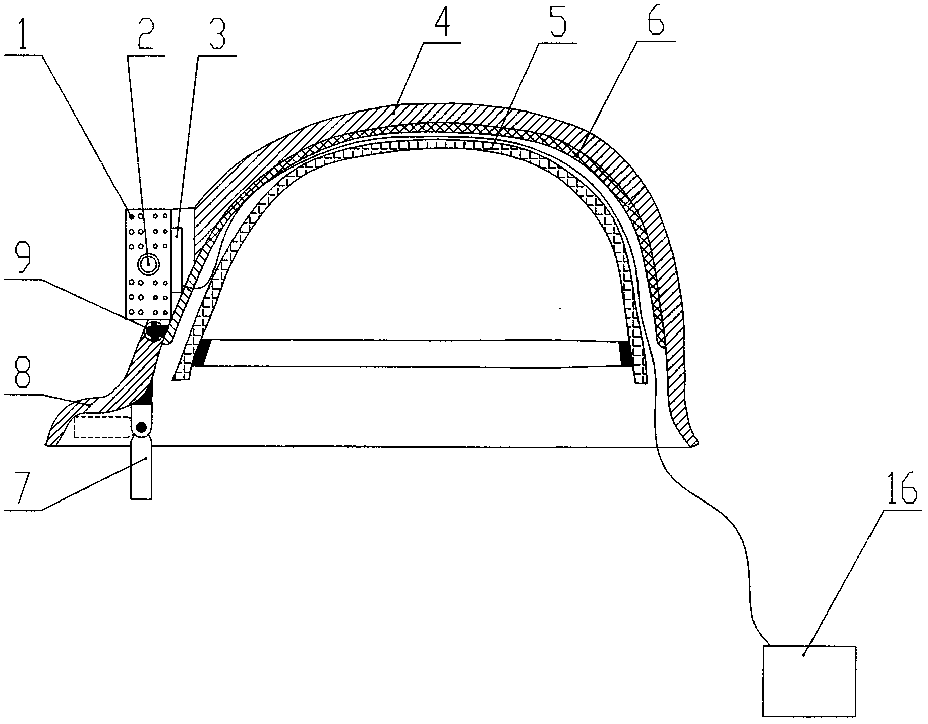
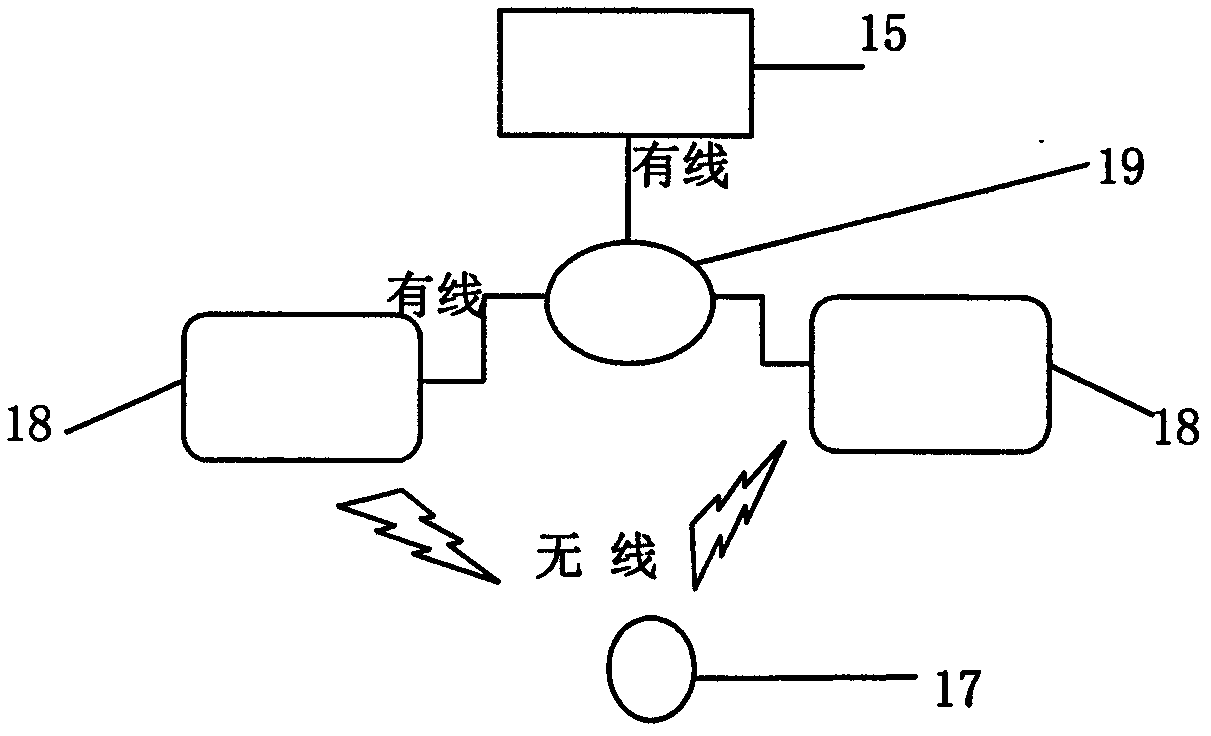
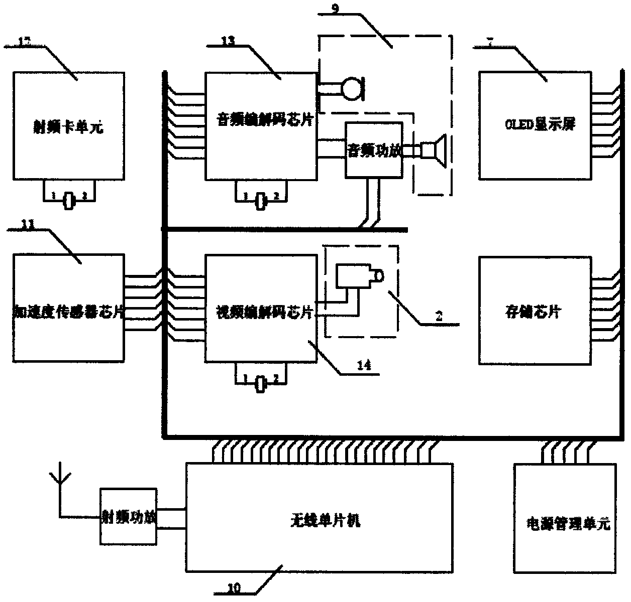
[0013] The functions of information collection, positioning, navigation and voice communication realized by the present invention are mainly realized by the smart helmet 17 and the smart wireless positioning communication base station 18 . The whole set of underground positioning navigation and information collection system such as figure 2 As shown, it consists of a smart helmet 17, a smart wireless positioning communication base station 18, a ring network device 19 and a ground monitoring center 15. The smart helmet 17 communicates with the intelligent wireless positioning communication base station 18 through wireless signals, and the intelligent wireless positioning communication base station 18 forms a wired local area network with the ground monitoring center 15 through the ring network equipment 19 .

[0014] When the system is implemented, the intelligent wireless positioning communication base station is first arranged in the underground roadway according to the comm...


PUM


Abstract

The invention discloses a method and a device achieving underground mine positioning and navigation, and relates to the fields of wireless communication, positioning and distance measurement. The method and the device can achieve high-accuracy positioning and navigation of underground mine personnel and moving equipment. Wireless communication field intensity information is utilized for judging the moving direction of a positioned target, the distance between the positioned target and an intelligent wireless positioning communication base station is measured and calculated through double integral of time by an acceleration sensor, after differentiation is conducted by a close-distance radio frequency identification card, a wireless positioning communication unit receives a coordinate value sent by the intelligent wireless positioning communication base station, accumulative errors of the acceleration sensor are corrected, high-accuracy positioning is achieved, and the device achieving the method is an intelligent helmet. The intelligent helmet integrates a wireless positioning communication unit, a low-power-consumption light emitting diode (LED) lamp group, an embedded type micro camera, an OLED display screen and a headset, and by means of interaction of the intelligent positioning locating communication base station and looped network equipment and a ground monitoring center, functions of video capture and transmission, double-direction voice communication, positioning, navigation and the like are achieved.

Description

technical field [0001] The invention relates to the fields of radio communication, positioning and distance measurement, in particular a device for realizing high-precision positioning and navigation of underground mine personnel and mobile equipment by using radio communication technology, electronic technology and computer application technology. Background technique [0002] In recent years, coal mines and non-coal mines have accidents in the production process. Knowing the specific location of underground personnel when an accident occurs can provide favorable conditions for rescue work. The state and the national safety management department attach great importance to the safe production of underground mines, and have introduced the construction standard of "six major systems of underground mines". [0003] Radio positioning technology includes conventional satellite positioning methods such as GPS / Beidou / GLONASS / Galileo, and short-distance wireless positioning methods ...

Claims


Application Information

Patent Timeline
Patent Type & Authority Applications(China)
IPC IPC(8): H04W4/02H04W64/00E21F17/18H04B1/38
CPCY02D30/70
Inventor 石国峰黄金英何文超常微樵永锋吕涛张海波
Owner DANDONG DONGFANG MEASUREMENT&CONTROL TECHCO
Why Eureka
Try Eureka