Method for reducing power consumption of GPS (Global Positioning System)

A GPS receiver and power consumption technology, which is applied in satellite radio beacon positioning systems, measuring devices, instruments, etc., can solve the problems of user experience degradation and high power consumption

Inactive Publication Date: 2013-08-07
易讯思创(北京)科技发展有限公司
View PDF0 Cites 24 Cited by
  • Summary
  • Abstract
  • Description
  • Claims
  • Application Information

AI Technical Summary

Problems solved by technology

[0011] The technical problem to be solved by the present invention lies in the problem of

Method used


Image

  • Method for reducing power consumption of GPS (Global Positioning System)

Examples


Example Embodiment

[0037] The present invention will be further described below with reference to the drawings and embodiments.

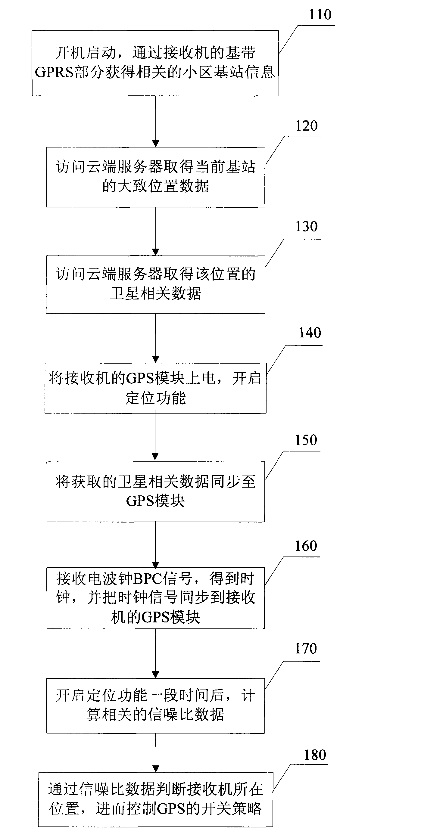
[0038] The purpose of the present invention is to provide a method for reducing the power consumption of GPS receivers, by increasing the number of satellites that can be searched, analyzing the signal-to-noise ratio of the satellites, and recovering the clock signal from the radio clock BPC signal, thereby greatly reducing the GPS chip searching for satellites Information working time, thereby reducing the power consumption of the receiver.

[0039] Such as figure 1 Shown is a schematic flow chart of a method for reducing power consumption of a GPS receiver according to the present invention.

[0040] The method for reducing the power consumption of a GPS receiver according to the present invention includes the following steps:

[0041] Step 110, start up, obtain relevant cell base station information through the baseband GPRS part of the receiver: Mobile Country Code (mcc)...


PUM


Abstract

The invention discloses a method for reducing power consumption of a GPS (Global Positioning System). The method comprises the following steps of obtaining information of a related cell base station by the GPS and further obtaining position information of a current base station by accessing a cloud server; acquiring satellite-correlated data of current position according to the position information, thereby realizing quick acquisition of the satellite-correlated data; on the other hand, receiving a signal of a radio controlled clock (BPC) and restoring an accurate clock, thereby shortening positioning time of a GPS receiver; and finally, judging the position where the current receiver is positioned by calculating signal-noise-ratio data and further controlling a switching strategy of a receiver GPS module. By using the method for reducing the power consumption of the GPS, the time for successfully positioning a GPS chip is greatly shortened, thereby correspondingly reducing the consumption of electric energy.

Description

technical field [0001] The invention relates to the field of positioning, in particular to a method for reducing power consumption of a GPS receiver. Background technique [0002] With the rapid growth of people's demand for BLS (Based Location Serices, location-based services), wireless positioning technology is also getting more and more attention. Positioning and navigation services have become the standard configuration of all mobile devices (smart phones, PDAs, etc.). Among the positioning and navigation technologies, GPS is naturally the most accurate and widely used. The GPS positioning system refers to a system that uses satellites to perform real-time positioning and navigation around the world, referred to as GPS (Global Positioning System). The basic principle of the GPS navigation system is to measure the distance between the known satellite and the user's receiver, and then integrate the data of multiple satellites to know the specific position of the receiver...

Claims


Application Information

Patent Timeline
IPC IPC(8): G01S19/34
Inventor 朱宇李仕秋彭明山陈小鹏孟振威王泰运
Owner 易讯思创(北京)科技发展有限公司
Why Eureka
Try Eureka