Method for determining soil erosion on drainage basin or regional scale

A regional scale, soil erosion technology, applied in soil material testing, material inspection products, etc., can solve the problems of large error, unsuitable promotion and application, difficult and fast application, etc., to achieve the effect of improved accuracy and easy promotion and use

Inactive Publication Date: 2013-09-11
NORTHWEST A & F UNIV
View PDF3 Cites 16 Cited by
  • Summary
  • Abstract
  • Description
  • Claims
  • Application Information

AI Technical Summary

Problems solved by technology

In the prior art, regional or watershed soil erosion measurement methods mostly use catchment area, unit runoff length and other values ​​instead of the true value, and the error is large, and the extraction efficiency of the algorithm is low, so it is difficult to Fast application on a large scale, not suitable for promotion and application

Method used


Image

  • Method for determining soil erosion on drainage basin or regional scale
  • Method for determining soil erosion on drainage basin or regional scale
  • Method for determining soil erosion on drainage basin or regional scale

Examples


Embodiment Construction

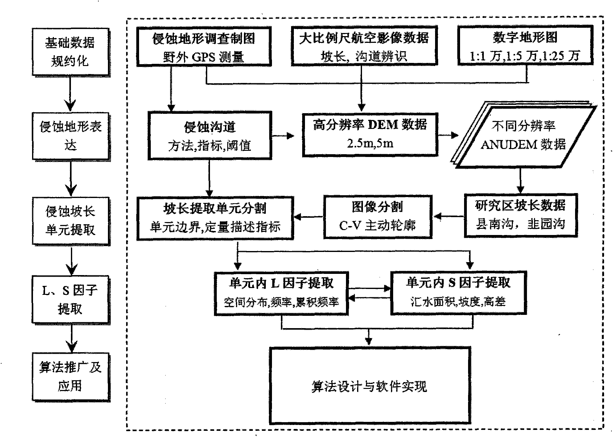
[0029] The present invention will be further described below in conjunction with the accompanying drawings and embodiments.

[0030] The present invention is based on geographic information system technology and digital terrain analysis technology, and based on digital elevation model, applies the idea of ​​water flow distribution strategy to slope length distribution, extracts slope length, slope, and then extracts L factor and S factor.

[0031] Such as figure 1 As shown, a soil erosion measurement method on the watershed or regional scale includes the following steps:

[0032] S1. Reduction of basic data. Erosion channel maps and digital elevation data are obtained through the construction of field GPS measurements, remote sensing data, and digital topographic maps. Using large-scale aerial photogrammetry, combined with high-resolution satellite remote sensing images, high-precision GPS topographic measurement data, within 1-2km 2 Acquire high-precision and high-resolutio...


PUM


Abstract

The invention discloses a method for determining the soil erosion on a drainage basin or regional scale. The method comprises the following steps of: S1, reducing basic data, constructing an erosion trench diagram and digital elevation data through field GPS measurement, remote sensing data and a digital topographic map; S2, expressing an erosional land form, so as to obtain a DEM with a correct hydrological relationship; S3, extracting an erosion slope length unit, calculating a gradient and a slope length according to the obtained digital elevation data of partial regions, and partitioning the slope length of the unit; S4, extracting an L factor and an S factor in erosion, figuring out the L factor and the S factor according to the extracted gradient and the extracted slope length; S5, popularizing and applying an algorithm and designing a corresponding algorithm. According to the method, the idea of a flow distribution strategy is innovatively applied to the extraction and calculation of the slope length of the unit, the slope length of the unit is deemed to be a basic calculating unit, the slope length is distributed according to the flow distribution strategy, the slope length and the gradient are calculated, and the L factor and the S factor are extracted, and thus the method can be conveniently and rapidly applied to a large region or drainage basin range for carrying out factor extraction and further measuring soil erosion and is easy to popularize and use, and the determining precision is greatly improved.

Description

technical field [0001] The invention relates to the field of soil erosion and computer technology, in particular to a method for extracting slope length and slope on a watershed or regional scale, and then measuring watershed-scale soil erosion. Background technique [0002] Soil erosion refers to the process of soil or soil parent material being destroyed, denuded, transported and deposited under the action of external forces (water, wind). my country is one of the countries with the most serious soil erosion in the world, and its scope is all over the country. The causes of soil erosion are complex and the hazards are serious. The main types of erosion are hydraulic erosion, wind erosion, gravity erosion, freeze-thaw erosion, and glacier erosion. According to the survey and statistics of the Remote Sensing Center of the Ministry of Water Resources in 1990, the national soil erosion area reached 4.92 million km 2 , accounting for 51% of the country's land area, of which t...

Claims


Application Information

Patent Timeline
Patent Type & Authority Applications(China)
IPC IPC(8): G01N33/24
Inventor 张宏鸣杨勤科李书琴刘晴蕊王美丽英明
Owner NORTHWEST A & F UNIV
Why Eureka
Try Eureka