Police service cloud image recognition vehicle management and control system based on geographic space-time constraint

A cloud image recognition and control system technology, applied in the field of image recognition, can solve the problem that fast vehicles cannot be effectively recognized, and achieve the effects of reducing the scope of image retrieval, increasing the speed of decomposition, and reducing the pressure on computing and network bandwidth

Active Publication Date: 2013-09-11
SUZHOU XIANGYI NETWORK TECH
View PDF9 Cites 25 Cited by
  • Summary
  • Abstract
  • Description
  • Claims
  • Application Information

AI Technical Summary

Problems solved by technology

[0004] The purpose of the present invention is to provide a police cloud image recognition vehicle management and control system based on geographic space-time constraints, which solves the problems in the prior art that vehicles cannot be effectively identified due to the rapidity and mobility of vehicles in road images.

Method used


Image

  • Police service cloud image recognition vehicle management and control system based on geographic space-time constraint
  • Police service cloud image recognition vehicle management and control system based on geographic space-time constraint
  • Police service cloud image recognition vehicle management and control system based on geographic space-time constraint

Examples


Embodiment

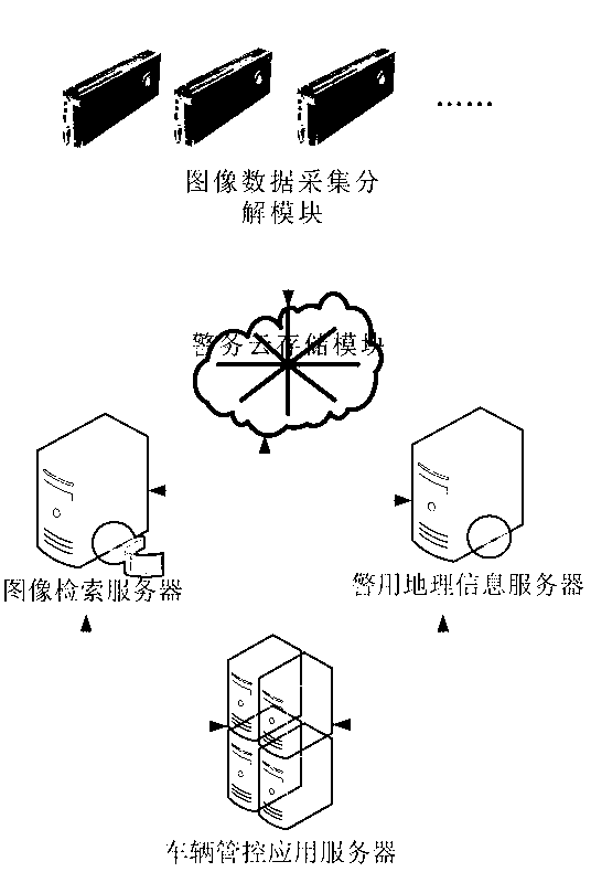
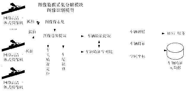
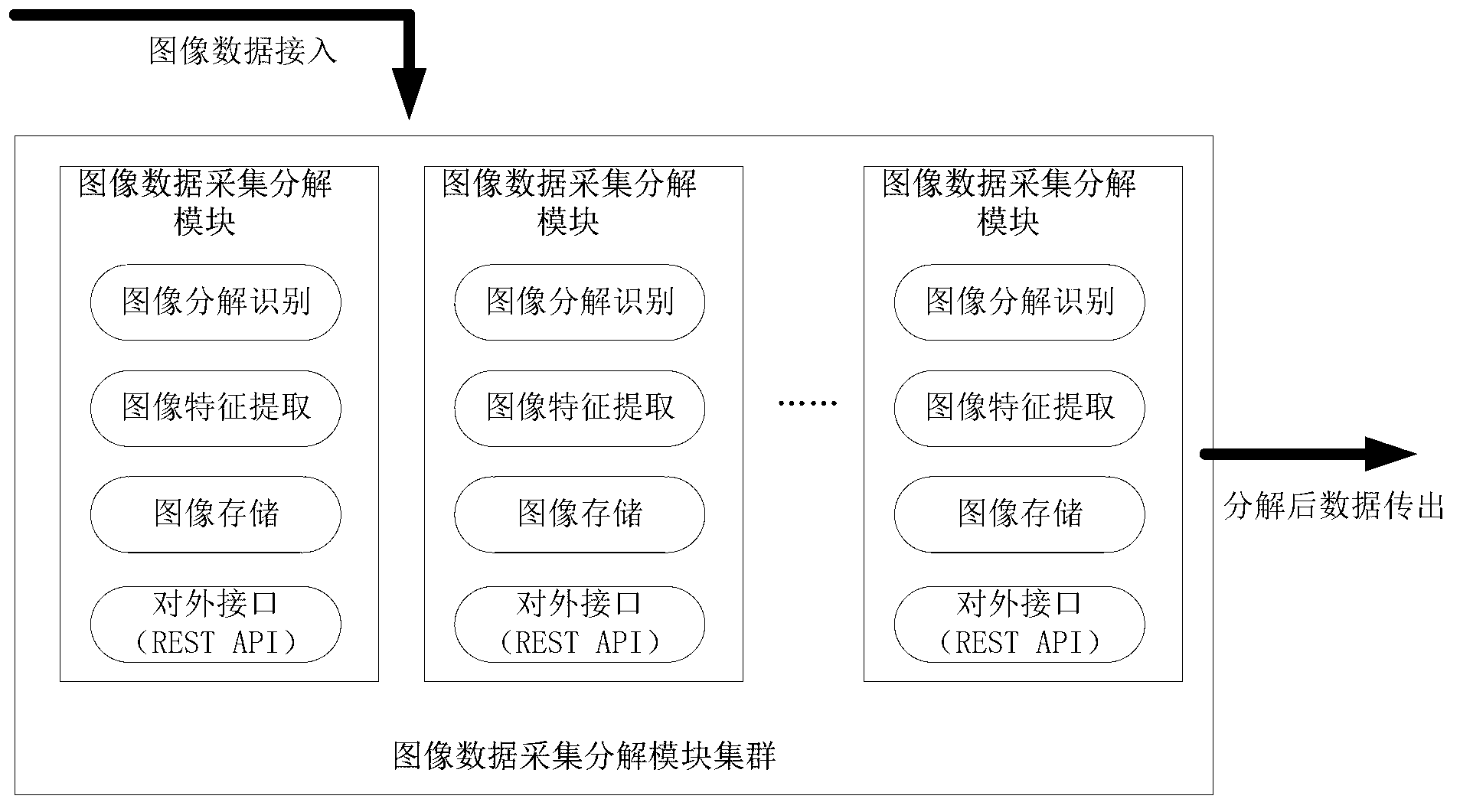
[0059] Such as figure 1 As shown, the police cloud image recognition vehicle management and control system based on geographic space-time constraints includes five parts: image data acquisition and decomposition module, image retrieval server, police cloud storage module, police geographic information server, and vehicle management and control application server. The image data acquisition and decomposition module described above adopts the image data acquisition and decomposition module based on GPU computing, solves a large number of parallel problems through the CUDA programming model, increases the decomposition speed of image features, and improves the image matching rate. At the same time, the distributed image data collection and decomposition modules are used for parallel computing to reduce the computing pressure and network bandwidth pressure of the server's centralized processing; Constraint narrows the scope of image retrieval, and then retrieves the required image...


PUM


Abstract

The invention discloses a police service cloud image recognition vehicle management and control system based on geographic space-time constraint. The system comprises an image data collection and decomposition module, an image retrieval module, a data storage module and a geographic information service module. The system is characterized in that the image data collection and decomposition module is responsible for collecting road images, extracting vehicle characteristics in the images and transmitting vehicle characteristic information in the images to the data storage module, the data storage module is used for storing the road images and image characteristic element data concerning the vehicle characteristic information in the images, the image retrieval module is used for responding to image retrieval requests of requesters, acquiring retrieval results meeting the image retrieval requests in an image retrieval mode mixing the image characteristic element data with geographic space-time constraint according to the image retrieval requests of the requesters and feeding the retrieval results back to the requesters, and the geographic information service module is used for responding to vehicle positioning requests of the requesters, acquiring vehicle space position information through a map server served by a geographic information platform and feeding the vehicle space position information back to the requesters.

Description

technical field [0001] The invention belongs to the technical field of image recognition, and in particular relates to a vehicle management and control system through checkpoints, video surveillance and other equipment, and in particular to a vehicle management and control system of geographic information system technology, image recognition technology, police cloud technology, and image retrieval technology. Background technique [0002] In recent years, under the unified leadership and deployment of the Ministry of Public Security, public security organs at all levels across the country have actively promoted the construction of safe cities. At present, more than 20 million surveillance cameras have been installed, of which more than one million surveillance cameras can be controlled by public security organs. Video images have gradually become an important resource for discovering criminal clues, collecting criminal data, and extracting criminal evidence. Especially in th...

Claims


Application Information

Patent Timeline
Patent Type & Authority Applications(China)
IPC IPC(8): G06F17/30G06K9/00
Inventor 张宏闵晓潮刘松
Owner SUZHOU XIANGYI NETWORK TECH
Why Eureka
Try Eureka