Polarimetric SAR (synthetic aperture radar) terrain classification method based on semantic information and polarimetric decomposition

A semantic information and feature classification technology, applied in the field of image processing and remote sensing, can solve problems such as poor consistency of classification areas, difficult areas, and boundaries easily affected by noise, and achieve the effect of improving regional consistency

A semantic information and feature classification technology, applied in the field of image processing and remote sensing, can solve problems such as poor consistency of classification areas, difficult areas, and boundaries easily affected by noise, and achieve the effect of improving regional consistency

CN103294792AActive Publication Date: 2013-09-11XIDIAN UNIV

Image

  • Polarimetric SAR (synthetic aperture radar) terrain classification method based on semantic information and polarimetric decomposition
  • Polarimetric SAR (synthetic aperture radar) terrain classification method based on semantic information and polarimetric decomposition
  • Polarimetric SAR (synthetic aperture radar) terrain classification method based on semantic information and polarimetric decomposition

Examples


Embodiment 1

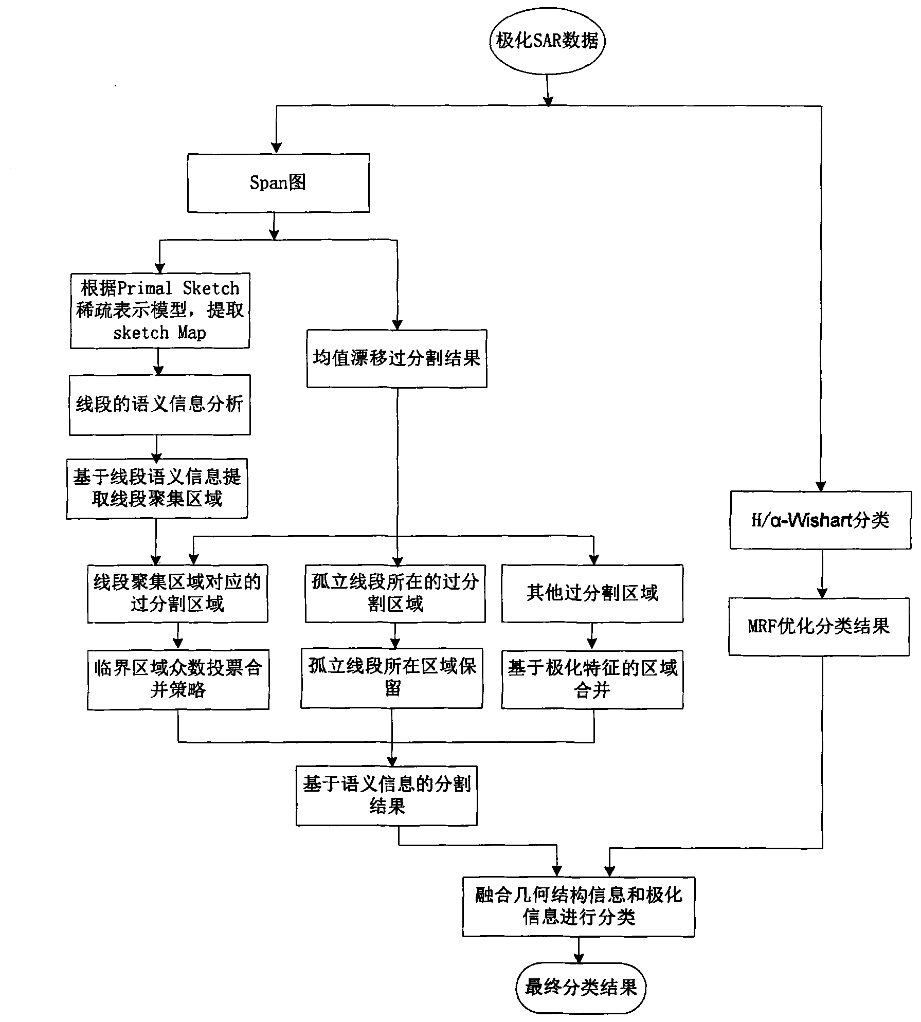
[0034] The present invention is a polarization SAR feature classification method based on semantic information and polarization decomposition, and performs unsupervised feature classification for low-resolution polarization SAR images acquired in advance, refer to figure 1 , The implementation steps of the classification process of the present invention include:

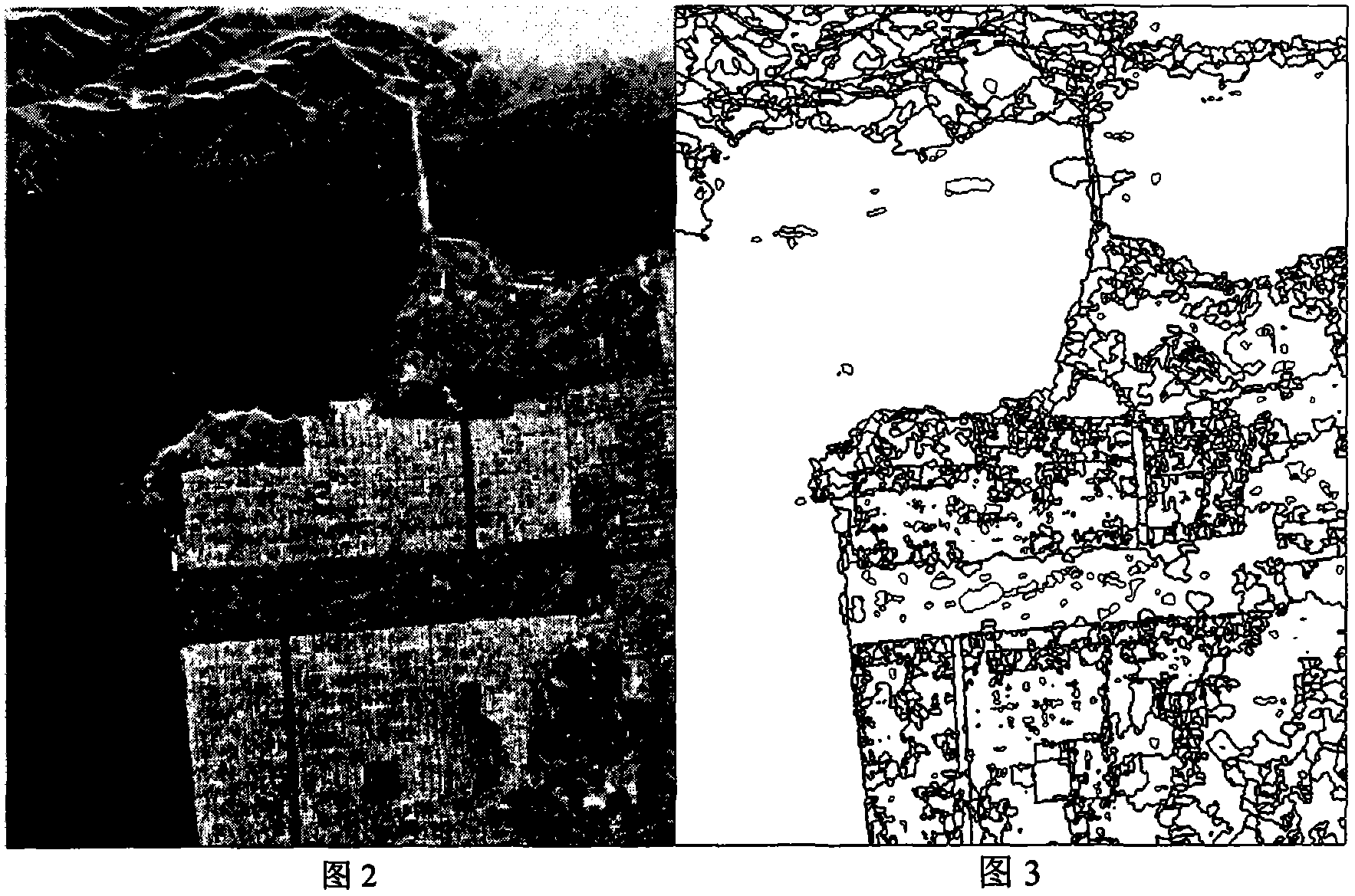
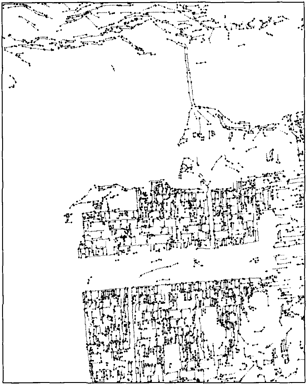
[0035] Step 1. Input the data of the polarization SAR image to be classified, process the polarization SAR data to obtain the amplitude values ​​of the three channels of the polarization SAR data, and fuse the amplitude values ​​of the three channels to obtain the backscatter of the polarization SAR image Total power graph, such as figure 2 Shown is the span map of NASA / JPLAIRSAR L-band fully polarized San Francisco data. Use the mean shift to the span graph to obtain the over-segmentation result graph of the span graph; and extract the ridge sketch composed of line segments of the span graph according to the prime sket...

Embodiment 2

[0081] The polarization SAR feature classification method based on semantic information and polarization decomposition is the same as that in Example 1. The simulated data and images are described as follows:

[0082] 1. Simulation conditions

[0083] (1) Select NASA / JPL AIRSAR L-band fully polarized San Francisco data;

[0084] (2) In the simulation experiment, Primal Sketch sparse means that the parameter N in the model is 3, M is 18, and the threshold ε is 20;

[0085] (3) In the simulation experiment, the number of nearest neighbors k is 9;

[0086] (4) In the simulation experiment, the seed line segment threshold δ 1 Take 20; line segment growth threshold δ 2 Take 12;

[0087] (5) In the simulation experiment, the region merging threshold U is set to 0.7;

[0088] (6) In the simulation experiment, the neighborhood window in the H / α-Wishart classification based on MRF is selected as 3*3.

[0089] 2. Simulation content and results

[0090] Using NASA / JPLAIRSAR L-band fully polarized San ...

Embodiment 3

[0092] The classification method of polarized SAR ground objects based on semantic information and polarization decomposition is the same as in embodiment 1-2, and the H / α-Wishart classification method based on MRF is the same as step 5 in embodiment 1. As a comparative experiment of the present invention, simulation The data and results are as follows:

[0093] 1. Simulation conditions

[0094] (1) Select NASA / JPLAIRSAR L-band fully polarized San Francisco data;

[0095] (2) In the simulation experiment, the neighborhood window in the H / α-Wishart classification based on MRF is selected as 3*3.

[0096] 2. Simulation content and results

[0097] Using NASA / JPL AIRSAR L-band fully polarized San Francisco data, the MRF-based H / α-Wishart classification method is used for classification, which is a pixel-based classification method. Picture 12 Is a span graph, Figure 13 It is the result of the H / α-Wishart classification method based on MRF. It can be seen from the figure that this metho...


PUM


Abstract

The invention discloses a polarimetric SAR (synthetic aperture radar) terrain classification method based on semantic information and polarimetric decomposition. The polarimetric SAR terrain classification method includes performing mean shift on a span image, extracting a sketch map of the span image, extracting a line segment gathering region in the sketch map by an region extracting technology based on the semantic information, merging span image mean shift over-segmentation regions based on the line segment gathering region as well as by the aid of a critical region majority vote merging strategy and based on a polarimetric feature merging strategy, acquiring an image segmentation result, and fusing the image segmentation result based on the semantic information and an H / alpha-Wishart classification result based on an MRF (markov random field) to acquire a final classification result. The semantic information, an image processing technique and a polarimetric scattering property are combined by the polarimetric SAR terrain classification method, the problem of bad region consistency of existing classification techniques based on the polarimetric decomposition to classification results with gathering-featured surface features (like forest, building groups and the like) is mainly solved, and region consistency and boundary retainability of the classification results with the gathering-featured surface features are improved.

Description

Technical field [0001] The invention belongs to the technical field of image processing and remote sensing, and relates to the classification of polarized SAR images. Specifically, it is a method for classification of polarized SAR ground objects based on semantic information and polarization decomposition. Resolve the ground object classification of polarized SAR images. Background technique [0002] Polarimetric Synthetic Aperture Radar (POLSAR) image processing is an important subject of national defense construction and economic development, and has attracted more and more attention and research. Compared with the ordinary single-polarization synthetic aperture radar (Synthetic Aperture Radar, SAR), the polarization SAR is a full-polarization measurement, can obtain more abundant ground information of the target, and provide more in-depth research on the scattering characteristics of the target. An important basis. Polarimetric SAR object classification is one of the import...

Claims


Application Information

Patent Timeline
11 Sep 2013
Publication
CN103294792A
IPC
G06F17/30
Inventors
刘芳; 石俊飞