UAV high resolution image geometric correction method based on error compensation

A technology of error compensation and geometric correction, applied in the field of geometric correction of unmanned aerial vehicle (UAV) high-resolution remote sensing images, can solve the problems of difficulty in meeting the real-time requirements of the UAV ground control station, inconvenient operation, and low real-time performance , to achieve high real-time requirements, improve flexibility, and improve work efficiency

Active Publication Date: 2013-10-09
北京北航天宇长鹰无人机科技有限公司
View PDF2 Cites 33 Cited by
  • Summary
  • Abstract
  • Description
  • Claims
  • Application Information

AI Technical Summary

Problems solved by technology

However, these methods require too much prior knowledge and manual intervention, low real-time performance, inconvenient operation, and difficult to meet the real-time requirements of UAV ground control stations.

Method used


Image

  • UAV high resolution image geometric correction method based on error compensation
  • UAV high resolution image geometric correction method based on error compensation
  • UAV high resolution image geometric correction method based on error compensation

Examples


Embodiment Construction

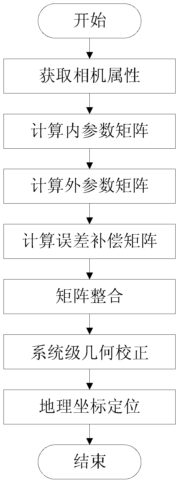
[0043] The specific implementation method of the present invention will be described in detail below in conjunction with the accompanying drawings.

[0044] The present invention takes the pinhole camera model as the research object, comprehensively considers the factors that cause the distortion of the remote sensing image of the UAV, determines the solution for the geometric correction of the remote sensing image based on the global perspective transformation, and solves the problem of the geographical coordinates of the distorted image after geometric correction. positioning problem.

[0045] The invention is a geometric correction method for high-resolution UAV remote sensing images. On the basis of comprehensive consideration of internal orientation factors and external orientation factors, the system-level geometric correction is carried out by introducing an error compensation mechanism, which greatly improves the accuracy of algorithm correction. . In addition, the pr...


PUM


Abstract

The invention discloses a UAV high resolution image geometric correction method based on error compensation. The UAV high resolution image geometric correction method based on the error compensation comprises the following steps that firstly, attribute parameters of an airborne camera are determined, and an internal parameter matrix Ain is calculated; secondly, external orientation parameters of remote-sensing images are obtained, and an external parameter matrix Aout is calculated; thirdly, on the basis of ground control points, an error compensation matrix Aerror_cmp is calculated; fourthly, correction matrixes are integrated; fifthly, on the basis of an overall situation transformation matrix A, geometric correction is conducted on the remote-sensing images; sixthly, geographical coordinates of the boundaries of the remote-sensing images are positioned. According to the UAV high resolution image geometric correction method based on the error compensation, factors causing geometric distortion of the remote-sensing images of an unmanned aerial vehicle are taken into consideration comprehensively, and accuracy of the UAV high resolution image geometric correction method is effectively improved through an error compensation mechanism. The UAV high resolution image geometric correction method based on the error compensation basically achieves automation of the whole course, certain parameter values can be used repeatedly once being calculated out, and work efficiency is improved greatly. According to the UAV high resolution image geometric correction method based on the error compensation, as height calibration parameters are brought in, geometric correction images of different types of resolution can be obtained according to requirements, and flexibility of the UAV high resolution image geometric correction method is improved.

Description

technical field [0001] The invention belongs to the technical field of digital image processing, and in particular relates to a geometric correction method for unmanned aerial vehicles (UAV) high-resolution remote sensing images based on error compensation. Background technique [0002] Due to the advantages of high resolution, high flexibility, high efficiency and low cost of low-altitude remote sensing data, UAVs are widely used in natural disaster area assessment, battlefield reconnaissance, environmental monitoring and other fields. However, compared with the rapid development of UAVs, UAV remote sensing image processing technology is relatively backward; compared with traditional aerospace images and aerial images, UAV remote sensing During survey and disaster monitoring, it is difficult to establish ground control points (GCP) measured in the field. These characteristics have brought difficulties to the precise geometric correction of UAV remote sensing images, especi...

Claims


Application Information

Patent Timeline
Patent Type & Authority Applications(China)
IPC IPC(8): G06T7/00
Inventor 丁文锐王家星李红光袁永显
Owner 北京北航天宇长鹰无人机科技有限公司
Why Eureka
Try Eureka