Cloud layer height measurement system and cloud layer height measurement method based on aircraft

A technology of height measurement and aircraft, applied in the direction of height/horizontal measurement, measuring devices, instruments, etc., can solve the problems of high price of laser ceilometer, increase of observation error, large error of cloud base, etc., and improve the measurement work Efficiency, simple structure, and the effect of ensuring safety

Active Publication Date: 2013-12-18
PLA UNIV OF SCI & TECH
View PDF6 Cites 7 Cited by
  • Summary
  • Abstract
  • Description
  • Claims
  • Application Information

AI Technical Summary

Problems solved by technology

Although there are many ways to obtain the height of cloud base, the more accurate method recognized so far is the result obtained by laser ceilometer observation, but due to the relatively expensive price of laser ceilometer and the narrow field of view of single point observation, in Large-scale application of ground observation stations is more difficult
Now it is more common to use satellite remote sensing to invert the cloud base height. Since the satellite observes from top to bottom, the cloud top height inversion is more accurate, while the cloud base information has a relatively large error.
At present, most ground weather stations use manual observation. Manual observation of cloud base height has great uncertainty and is greatly affected by visibility. Especially at night, when the light is insufficient, cloud curtain lights are needed. Auxiliary observation, which increases the error of observation, so the error of cloud base height value of manual observation is very large

Method used


Image

  • Cloud layer height measurement system and cloud layer height measurement method based on aircraft
  • Cloud layer height measurement system and cloud layer height measurement method based on aircraft
  • Cloud layer height measurement system and cloud layer height measurement method based on aircraft

Examples


Embodiment Construction

[0040] The specific implementation manners of the present invention will be further described in detail below in conjunction with the accompanying drawings.

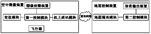
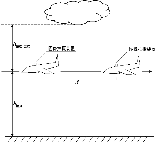
[0041] Such as figure 1 As shown, the present invention has designed a kind of cloud layer height measuring system based on aircraft, comprises aerial measuring device and ground control device, and described aerial measuring device comprises aircraft, and the first control module that is arranged on aircraft, positioning module, on-board communication Module, image capture device; Wherein, positioning module, on-board communication module and image capture device are connected with the first control module respectively, and image capture device is arranged on the aircraft surface vertically upwards with the shooting direction; Described ground control module includes the second control module module, and a ground communication module and an information output device respectively connected to the second control module; t...


PUM


Abstract

The invention relates to a cloud layer height measurement system based on an aircraft. The cloud layer height measurement system comprises an air measuring device and a ground control device. The air measuring device comprises the aircraft, a first control module, a location module, an airborne communication module and an image shooting device, wherein the first control module, the location module, the airborne communication module and the image shooting device are arranged on the aircraft, the image shooting device is perpendicularly arranged on the surface of the aircraft upwards in the shooting direction, the ground control module comprises a second control module, a ground communication module and an information output device, and the ground communication module and the information output device are connected with the second control module. The invention meanwhile relates to a cloud layer height measurement method. By means of the cloud layer height measurement system and the cloud layer height measurement device based on the aircraft, the cloud top height or the cloud base height can be flexibly and accurately measured according to measurement requirements, and the measurement work efficiency is effectively improved.

Description

technical field [0001] The invention relates to an aircraft-based cloud height measurement system and a cloud height measurement method. Background technique [0002] As an important parameter of cloud physical characteristics, cloud base height has an important impact on air quality, acid rain, sunshine rate, agricultural drought, and boundary layer turbulence. A detailed understanding of different types of cloud layers and cloud base heights and their evolution under different dynamic conditions is not only helpful for monitoring and forecasting weather systems, but also for research on global climate change. important criterion. [0003] So far, there are mainly five ways to determine the height of cloud base. The height of the cloud base can be obtained directly by laser ceilometer; the height of the cloud base can be obtained by inversion of satellite remote sensing data; the height of the cloud base can be detected by millimeter-wave radar or lidar; Cloud base heigh...

Claims


Application Information

Patent Timeline
Patent Type & Authority Applications(China)
IPC IPC(8): G01C5/00
Inventor 王敏周树道陈晓颖黄峰刘志华刘凤徐四林文滋木曹瑞明
Owner PLA UNIV OF SCI & TECH
Why Eureka
Try Eureka