Three-dimensional terrain and radar terrain generating method based on S-57 electronic chart data

A technology for electronic charts and three-dimensional terrain, applied in image data processing, electrical digital data processing, special data processing applications, etc., can solve problems such as increased hardware requirements, data differences, rough description of land terrain elevation information, etc., to ensure operation Efficiency and realism, effects that improve precision

Inactive Publication Date: 2013-12-18
PLA DALIAN NAVAL ACADEMY
View PDF2 Cites 35 Cited by
  • Summary
  • Abstract
  • Description
  • Claims
  • Application Information

AI Technical Summary

Problems solved by technology

Due to the rough description of the land terrain elevation information in the electronic chart, there is a big difference between the data provided in the simulation process and the actual environment
Furthermore, this method does not provide continuous, precise data for the area between contours and isobaths
These all affect the objectivity and fidelity of the si...

Method used


Image

  • Three-dimensional terrain and radar terrain generating method based on S-57 electronic chart data
  • Three-dimensional terrain and radar terrain generating method based on S-57 electronic chart data
  • Three-dimensional terrain and radar terrain generating method based on S-57 electronic chart data

Examples


Embodiment Construction

[0040] The present invention will be further described below in conjunction with the accompanying drawings and embodiments.

[0041] Taking the terrain model data extracted from the Jiangyin Bridge of the Yangtze River Channel to the Yangtze River Estuary as an example, the specific implementation of the three-dimensional terrain and radar terrain generation method based on the S-57 electronic chart data of the present invention is as follows:

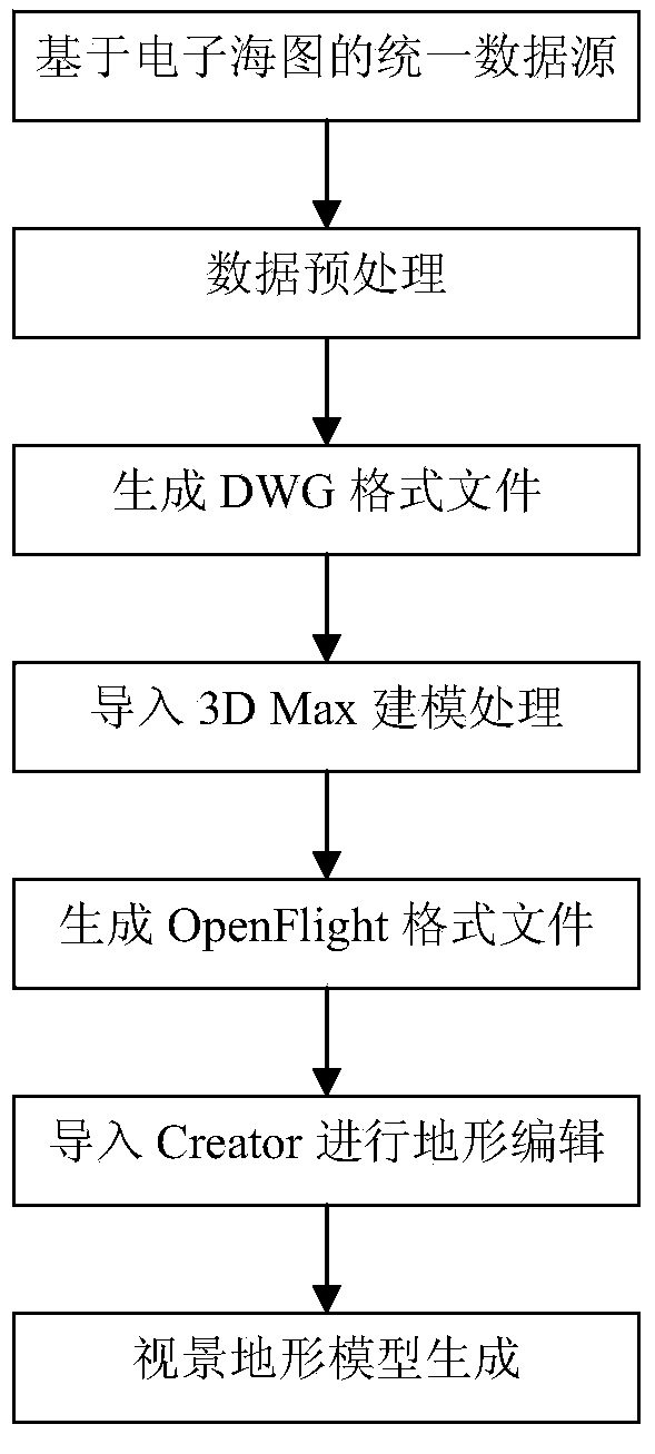
[0042] First, install the following software on your computer:

[0043] 1) Global Mapper11;

[0044] 2) 3D Max7 and PloyTrans plugins;

[0045] 3) Multigen Creator 3.0.

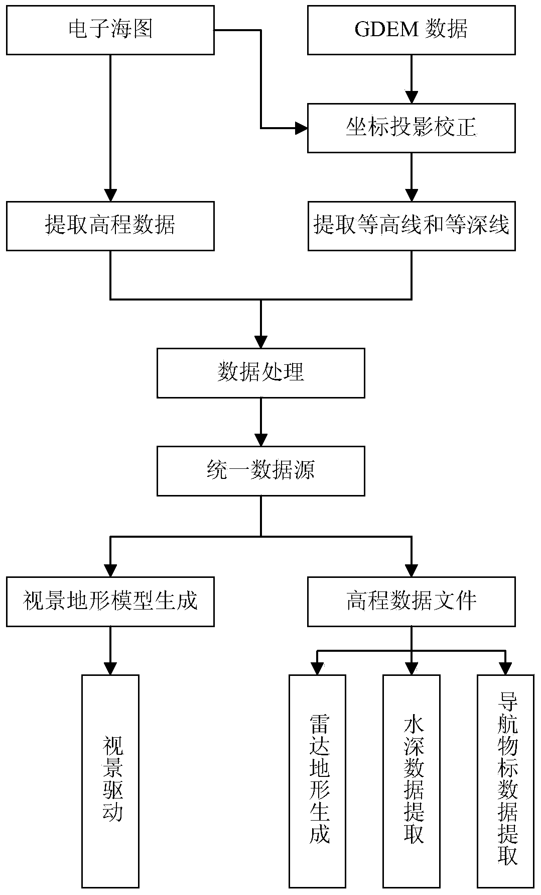
[0046] 1 Unified data source generation

[0047] 1.1 Raw data extraction

[0048] Based on the electronic chart source data, the GIS software Global Mapper was used to extract the chart elevation information, including coastlines, contour lines, contour lines, and water depth points. Import the GDEM data into Global Mapper, correct the GDEM data according to the ...


PUM


Abstract

The invention provides a three-dimensional terrain and radar terrain generating method based on S-57 electronic chart data. The three-dimensional terrain and radar terrain generating method comprises the steps that firstly, an elevation vector graph based on an electronic chart is generated based on the S-57 electronic chart data and through the combination of GDEM data, and the elevation vector graph serves as an uniform data source; secondly, the elevation vector graph undergoes conversion, simplification and texture mapping to generate a scene three-dimensional terrain model; at last, based on the elevation vector graph and through cutting of the data, radar terrain data generation and water depth data and navigation target data extraction are respectively completed at different sampling intervals according to needs. The three-dimensional terrain and radar terrain generating method based on the S-57 electronic chart data overcomes the defects that an existing terrain model is not uniform in data matching, not high in precision and poor in running efficiency; the three-dimensional terrain data generating technology, the GPS positioning technology and the GIS geological information technology are integrated, so that the three-dimensional scene running efficiency and the three-dimensional scene vividness are guaranteed, and meanwhile, accurate matching between scene three-dimensional terrain data, radar terrain data, water depth data and navigation target data and the electronic chart is realized.

Description

technical field [0001] The invention relates to a method for generating three-dimensional terrain and radar terrain, in particular to a method for generating three-dimensional terrain and radar terrain of a navigation simulator based on large-scale high-precision matching of S-57 electronic chart data. Background technique [0002] In recent years, with the continuous development of the application of virtual reality technology, it has been successfully applied in urban construction, education, e-commerce, military industry and other fields. Among them, domestic scientific research institutions and colleges have independently developed ship maneuvering simulators with three-dimensional views, which have played an important role in crew ship maneuvering training and port and shipping design demonstrations. [0003] In the development and application of virtual reality technology of ship maneuvering simulator, the extraction of 3D visual terrain, radar terrain, water depth dat...

Claims


Application Information

Patent Timeline
IPC IPC(8): G06T17/05G06F17/50
Inventor 宋元牛海李彩霞汪志凯许林周周晶刘喜作李智王艺胡蕾
Owner PLA DALIAN NAVAL ACADEMY
Why Eureka
Try Eureka