Scenic spot scenery moving augmented reality method based on space relationship and image analysis

A spatial relationship and image analysis technology, applied in image analysis, image data processing, instruments, etc., can solve the problems of inability to accurately locate the outline of the target, high algorithm efficiency requirements, and difficult to guarantee recognition rate, etc., and achieve low equipment hardware requirements , strong versatility, simple effect

Inactive Publication Date: 2014-01-08
HANGZHOU NORMAL UNIVERSITY
View PDF3 Cites 23 Cited by
  • Summary
  • Abstract
  • Description
  • Claims
  • Application Information

AI Technical Summary

Problems solved by technology

Most of the augmented reality technologies currently widely used are based on three methods. One is label implementation, that is, a certain label image is predefined in the system, and the target is defined by identifying the label image. It is not applicable in complex outdoor scenes, and the recognition is relatively difficult; the second is based on the spatial relationship, that is, the GPS and sensors of the smartphone are used to locate the target. Outline, recognition accuracy is poor; the third method is based on image recognition technology, real-time analysis of images by computer, using complex machine learning algorithms to identify targets, its applicability is slightly stronger than methods 1 and 2, but requires equipment with powerful Computing power requires high efficiency of the algorithm, and the recognition rate is difficult to guarantee

Method used


Image

  • Scenic spot scenery moving augmented reality method based on space relationship and image analysis
  • Scenic spot scenery moving augmented reality method based on space relationship and image analysis
  • Scenic spot scenery moving augmented reality method based on space relationship and image analysis

Examples


Embodiment

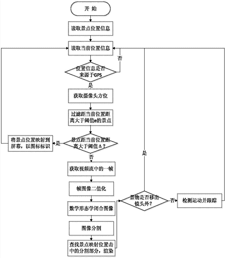
[0048] First of all, according to the actual data, the spatial database of the scene entity in the wetland scenic spot is established, including the category of the scene and the longitude and latitude coordinates of the scene entity. All data entity objects are identified by unique identification codes and spatial indexes are established. The database is stored embedded in the smartphone.

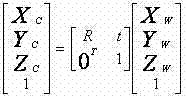
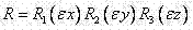
[0049] Then, establish a multi-sensor-based camera lens field of view model and the corresponding relationship between the image of the real scene and the actual geographic space: a reference coordinate system is also selected in the environment to describe the position of the object, which is called the world coordinate system. The rectangular coordinate system composed of the camera optical center as the origin O, the mutually orthogonal X and Y axes parallel to the imaging plane, and the Z axis perpendicular to the imaging plane is called the reference coordinate system. The relationsh...


PUM


Abstract

The invention discloses a scenic spot scenery moving augmented reality method based on space relationship and image analysis. The method comprises the following steps that a geographical space data model facing an object is adopted for building a scenic spot geographical database according to the scenic spot scenery moving augmented reality guide demands and the scenic spot scenery space data organization characteristics; a built-in sensor of an intelligent mobile phone is adopted for obtaining the current position coordinates and the space orientation, an image pick-up view sight model based on multiple sensors is built, and the corresponding relationship between the real scenery images and the actual geographical space is generated; key frames are extracted from video image flows shot by the intelligent mobile phone and are fast divided sequentially through binaryzation and mathematical morphology methods; the visual matching between the real scenery space and the information space is realized through a measure of combining the image analysis with the space relationship, and the scenic spot scenery is identified; and the identified scenery is subjected to tracking registration by a moving detection method. The scenic spot scenery moving augmented reality method overcomes the defects of poor precision and low image identification technology efficiency of a space relationship realization method.

Description

technical field [0001] The invention relates to the technical field of mobile augmented reality, in particular to a mobile augmented reality method for sceneries in scenic spots based on spatial relationship and image analysis. This method has important practical significance and application prospects in the informatization of tourist attractions and the automation of tourist guidance. In addition, the present invention is also applicable to other mobile augmented reality applications. Background technique [0002] Augmented reality technology can integrate the computer-generated virtual environment with the real environment to produce highly expressive sensory effects, which is especially suitable for outdoor tourism and scenic spot guidance. By using smart phones as carriers, GIS technology and augmented reality technology Combined, it provides a new solution for tourists' positioning and navigation, greatly improves the user experience of scenic tours, and at the same ti...

Claims


Application Information

Patent Timeline
Patent Type & Authority Applications(China)
IPC IPC(8): G06T7/00G06T7/20
Inventor 毛峰刘婷宋瑜张伟祝炜平王春叶潘君斌
Owner HANGZHOU NORMAL UNIVERSITY
Why Eureka
Try Eureka