
Passive location system using universal irradiation source of unmanned plane

A passive positioning and irradiation source technology, applied in satellite radio beacon positioning system, radio wave measurement system, positioning, etc., can solve the problem of reducing usability and achieve the effect of improving positioning accuracy

Active Publication Date: 2014-03-05
CHINA ACAD OF AEROSPACE AERODYNAMICS
View PDF7 Cites 10 Cited by
  • Summary
  • Abstract
  • Description
  • Claims
  • Application Information

AI Technical Summary

Problems solved by technology

Among them, GPS, GLONASS, and Beidou belong to satellite positioning, which have a wide range of applications and high precision, and are the main positioning means; but because of their important role, they are easy to become the main target of attack; thus reducing their usability

Method used


Image

  • Passive location system using universal irradiation source of unmanned plane
  • Passive location system using universal irradiation source of unmanned plane
  • Passive location system using universal irradiation source of unmanned plane

Examples


Embodiment Construction

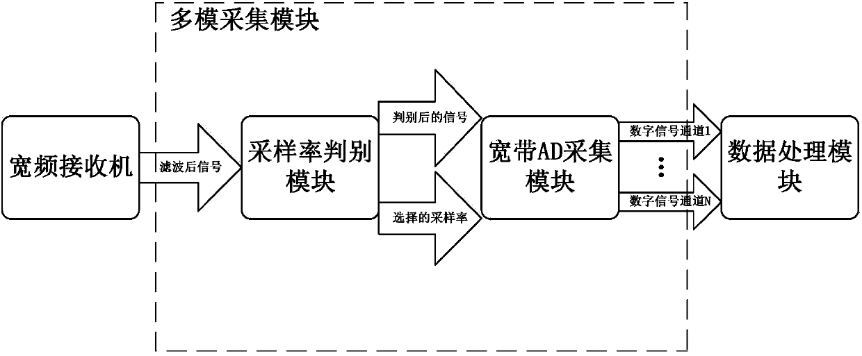
[0030] like figure 1 As shown, the present invention provides a passive positioning system for unmanned aerial vehicles utilizing a general illumination source, installed on the unmanned aerial vehicle, including: receiving antenna, antenna servo module, broadband receiver, multi-mode acquisition module and data processing module;

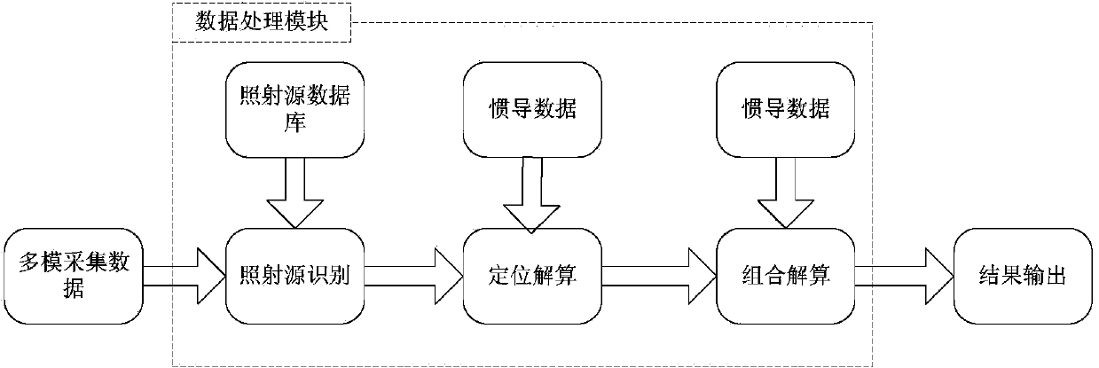
[0031] The antenna servo module controls the receiving antenna to rotate 360°, receives the signals sent by the multiple general irradiation sources, and sends the received signals to the broadband receiver, and the broadband receiver filters the signals, and sends the filtered signals to the into the multi-mode acquisition module, the multi-mode acquisition module sequentially performs analog-to-digital conversion and digital down-conversion on the signals input into the module, and then sends the generated digital signals to the data processing module for processing, and obtains the UAV relative to the above-mentioned Location of multiple common...


PUM


Abstract

The invention relates to a passive location system using a universal irradiation source of an unmanned plane. The system and a method provided by the invention are used for geo-location of the unmanned plane through the conventional irradiation source (such as a radio transmission device for civil use) when a global position system (GPS) such as Big Dipper is disturbed or fails. The unmanned plane system can automatically control flying without manual control, namely, the unmanned plane system can fly along the preset air route independently, but in the present stage, autonomous flight depends on position information obtained by calculating of satellite navigation systems and inertial navigation devices, for example, the GPS, the Big Dipper and an inertial navigation unit, then a flight control system controls the unmanned plane to fly independently according to the current position and the target position of the unmanned plane, and therefore, the self location is the foundation of autonomous flight control. The passive location system can be applied to a flight platform and is used as a backup locator device for offering navigation information when universal navigation systems such as the GPS and the Big Dipper cannot work normally.

Description

Technical field [0001] The invention relates to a passive positioning system for unmanned aerial vehicles using a universal illumination source, which realizes and solves the problem of using conventional universal illumination sources to perform positioning on unmanned aerial vehicles when satellite positioning systems such as GPS, GLONASS, and Beidou are interfered with or fail. Geolocation confirmation. Background technique [0002] UAV technology is an important development direction of military equipment technology in the 21st century. In several local wars in the past 10 years, UAVs have exerted great power. In the civilian market, drones have also grown from scratch, from few to many, showing great application value and potential in many industries. [0003] The UAV system can achieve autonomous flight, that is, autonomous flight according to a pre-designed route. Autonomous flight is an important basis for the application of UAV; at this stage, autonomous flight mai...

Claims


Application Information

Patent Timeline
IPC IPC(8): G01S5/16
CPCG01C21/165G01S5/16G01S19/48G01S19/49
Inventor 樊自伟吴洋
Owner CHINA ACAD OF AEROSPACE AERODYNAMICS
Learn More