Unmanned aerial vehicle routing inspection image retrieval system and method based on electric transmission line and GIS

A power transmission line and image retrieval technology, which is applied in the direction of electrical digital data processing, special data processing applications, instruments, etc., can solve the problems of retrieving images, no application, and inability to apply unmanned aerial vehicle transmission line inspections, etc., to reduce costs , the effect of improving efficiency

Active Publication Date: 2014-06-04
STATE GRID INTELLIGENCE TECH CO LTD
View PDF7 Cites 45 Cited by
  • Summary
  • Abstract
  • Description
  • Claims
  • Application Information

AI Technical Summary

Problems solved by technology

For example, Yuan Hui, Yu Ping and others from North China Electric Power University’s “Research on Image Feature Extraction and Classification of Power Equipment” and Sun Xia and Wang Zhijie’s “Fault Diagnosis of Large Substation Remote Monitoring System” focus on image content and power Equipment feature information, identifying the type of equipment in the image, classifying the image, and realizing the retrieval of the equipment image, but this method can only identify the equipment type, not the equipment model, and cannot compare the image with the corresponding transmission line section, tower number, Correlation of inspection geographic information
The patent "A Dictionary Image Retrieval System" with the application number "200910077920.2" retrieves image information according to the index table, but does not provide how to retrieve images corresponding to image attribute information or content
"Image Retrieval Clustering Method for WEB2.0 Labeled Image Shared Space" with application number "200910152883.7" and "Clustering-Based Correlation Feedback Retrieval Method in Network Image Search" with application number "200810104942.9", through cluster analysis The image classification and ret...

Method used


Image

  • Unmanned aerial vehicle routing inspection image retrieval system and method based on electric transmission line and GIS
  • Unmanned aerial vehicle routing inspection image retrieval system and method based on electric transmission line and GIS
  • Unmanned aerial vehicle routing inspection image retrieval system and method based on electric transmission line and GIS

Examples


Embodiment Construction

[0055] The present invention will be further described below in conjunction with the accompanying drawings and embodiments.

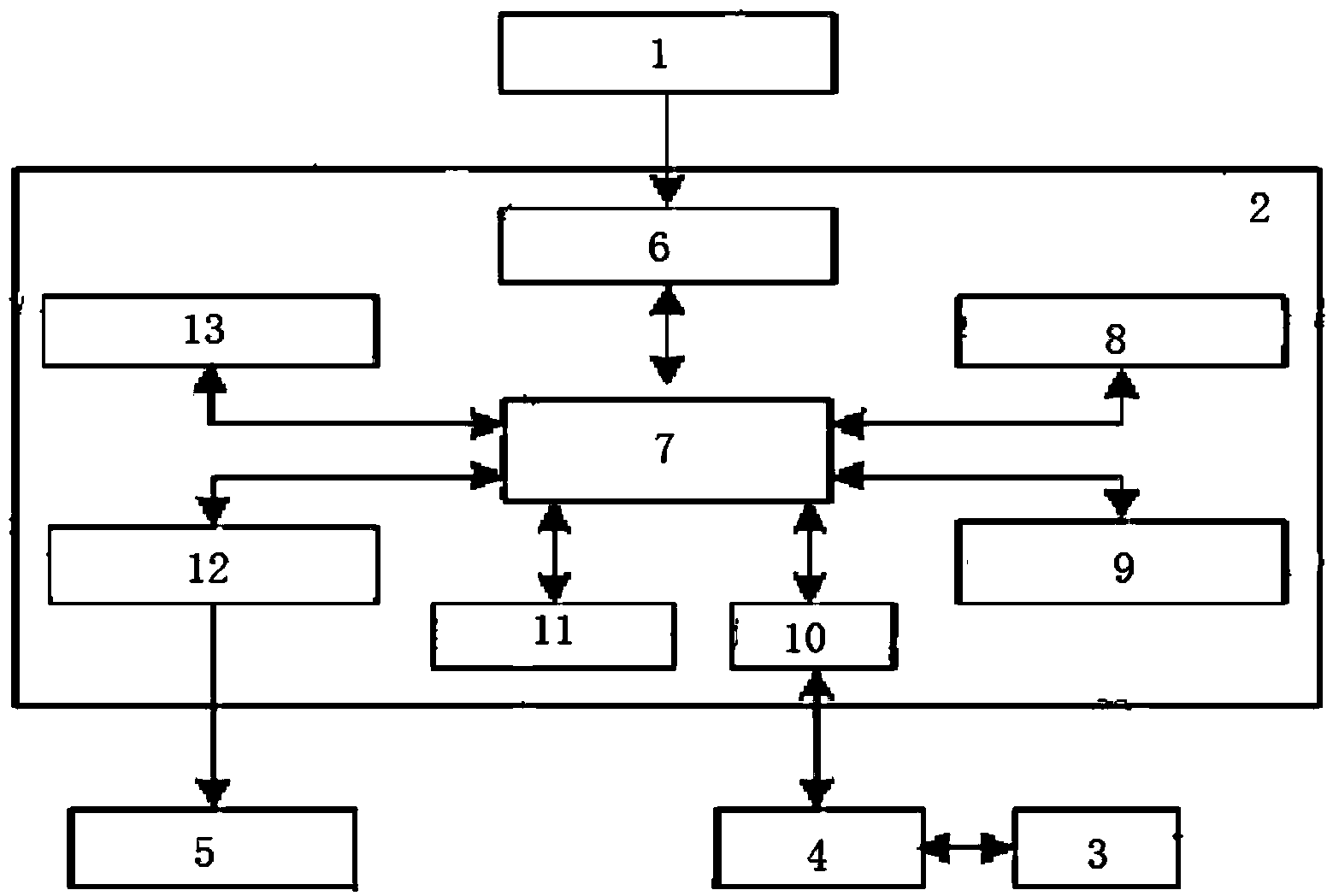
[0056] Such as figure 1 As shown, a drone inspection image retrieval system based on power transmission lines and GIS includes: image processing server 2, external signal input device 1, result display device 5, drone 3 and ground monitoring station 4; wherein, One-to-one or one-to-many connection is realized between the image processing server 2 and the ground monitoring station 4, one-to-one connection between the external signal device 1 and the image processing server 2, and one-to-one connection between the result display device 5 and the image assistant server 2 a connection.

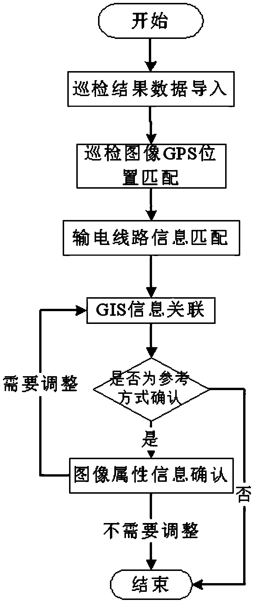
[0057] The above-mentioned image processing server 2 is used to complete the GPS position matching of the input inspection data and the matching of the transmission line information, associate with the GIS information, and retrieve the corresponding inspection image accord...


PUM


Abstract

The invention discloses an unmanned aerial vehicle routing inspection image retrieval system and method based on an electric transmission line and a GIS. The unmanned aerial vehicle routing inspection image retrieval system comprises an image processing server, an external signal input device, a result display device, an unmanned aerial vehicle and a ground monitor station. The external signal input device inputs external signals or instructions to the image processing server, the result display device outputs a processing result of the image processing server, the ground monitor station reads the flight state information and routing inspection result data of the unmanned aerial vehicle and sends the read data to the image processing server, and the ground monitor station is in wireless communication with the image processing server. By means of the unmanned aerial vehicle routing inspection image retrieval system and method based on the electric transmission line and the GIS, the data retrieving and processing efficiency of the routing inspection result can be improved, the image processing cost in routing inspection is lowered, the image retrieving and processing speed of the server is increased, and the processing time cost of the routing inspection result is lowered.

Description

technical field [0001] The invention belongs to the field of operation and maintenance of power systems, and in particular relates to an image retrieval system and method for unmanned aerial vehicle inspection based on power transmission lines and GIS. Background technique [0002] UAV line inspection is playing an increasingly important role in transmission line inspection, which can greatly reduce the workload of power service personnel, reduce the probability of possible personnel danger, reduce the maintenance cost of power equipment, and improve the safety of the power grid sex and reliability. [0003] In the process of UAV inspection, the processing of inspection results is the core content of UAV inspection. How to efficiently and quickly process the data images of the results of UAV inspections, and match the images captured by UAV inspections with the inspection transmission line information has always been a problem that plagues UAV inspections. In the process o...

Claims


Application Information

Patent Timeline
IPC IPC(8): G06Q50/06G06F17/30
Inventor 王滨海张方正张明江董罡刘俍张晶晶郑天茹慕世友任杰魏传虎王万国
Owner STATE GRID INTELLIGENCE TECH CO LTD
Why Eureka
Try Eureka