Multisource multi-area-array GIS data acquisition platform for unmanned vehicle

A technology for data collection and unmanned vehicles, applied in the field of surveying and mapping geographic information, can solve the problems of high total cost, difficult calibration, and time-consuming, and achieve the effects of high efficiency, reliability, cost performance, work efficiency, and high accuracy.

Inactive Publication Date: 2014-06-25
HUAZHONG NORMAL UNIV
View PDF4 Cites 19 Cited by
  • Summary
  • Abstract
  • Description
  • Claims
  • Application Information

AI Technical Summary

Problems solved by technology

The position and direction of the support frame and the imaging equipment of the target are basically fixed, and cannot be easily changed and adjusted;
[0004] 2) Accuracy problem
[0005] 3) Calibration and adaptability issues
The traditional vehicle-mounted mobile measurement system has a complex structure, difficult and time-consuming calibration, and due to its large size, it is not suitable for applications in some special environments, such as data acquisition of 3D modeling in indoor scenes;
[0006] 4) Price issues
Since most of the hardware is composed of the most advanced equipment and modules (for example: Lidar laser radar), the total cost of the whole system is very expensive, and the price of domestic and foreign systems is in the millions.
[0007] The above problems restrict the working efficiency of mapping in mobile surveying to a certain extent

Method used


Image

  • Multisource multi-area-array GIS data acquisition platform for unmanned vehicle
  • Multisource multi-area-array GIS data acquisition platform for unmanned vehicle
  • Multisource multi-area-array GIS data acquisition platform for unmanned vehicle

Examples


Embodiment Construction

[0026] In order to facilitate those of ordinary skill in the art to understand and implement the present invention, the present invention will be described in further detail below in conjunction with the accompanying drawings and embodiments. It should be understood that the implementation examples described here are only used to illustrate and explain the present invention, and are not intended to limit this invention.

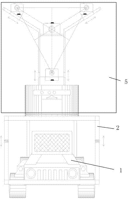
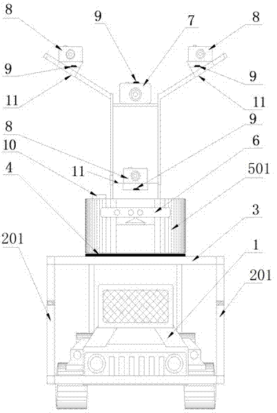
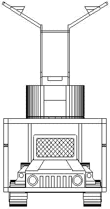
[0027] please see figure 1 , figure 2 , image 3 , Figure 4 and Figure 5, the technical solution adopted in the present invention is: a multi-source multi-area array unmanned vehicle GIS data acquisition platform, including a mobile carrying platform, a multi-source multi-area array sensor, positioning and attitude determination and its control module and power supply device; The platform is composed of an unmanned remote control electric vehicle 1, a support system 2, a 360° multi-source multi-surface array sensor rotating platform 5 and a wireless re...


PUM


Abstract

The invention discloses a multisource multi-area-array GIS data acquisition platform for an unmanned vehicle. The multisource multi-area-array GIS data acquisition platform for the unmanned vehicle comprises a mobile carrying pan-tilt, a multisource multi-area-array sensor, a position, orientation and control module and a power supply device. A multisource multi-area-array rotating pan-tilt is installed on the unmanned electric vehicle through a supporting rod and a supporting platform. Mobile measurement is conducted through remote control. A photographic base can be adjusted at will when the platform acquires data. The platform can flexibly rotate by 360 degrees to operate in an area with the shape similar to a hemisphere. The special arrangement structure of the multisource multi-area-array rotating pan-tilt is an equilateral triangle, wherein ordinary cameras are arranged at the three end points of the equilateral triangle, a digital single lens reflex camera is arranged at the orthocenter of the equilateral triangle, and the multisource multi-area-array rotating pan-tilt has the most remarkable advantage of being capable of improving the automation and precision of data processing at the same time. A Kinect camera is additionally arranged, so that a multisource sensing mode is formed, and then GIS data synchronous acquisition can be conducted in combination with a DGPS / IMU. The multisource multi-area-array GIS data acquisition platform for the unmanned vehicle has the advantages of being scientific, flexible, high in accuracy, high in adaptability, efficient, reliable, high in cost-performance ratio, capable of greatly improving data acquisition efficiency and data post-processing efficiency and the like.

Description

technical field [0001] The invention belongs to the field of surveying and mapping geographic information, and relates to a multi-source and multi-area array unmanned vehicle GIS data collection platform. Background technique [0002] At present, the construction of smart cities is in full swing. How to obtain geospatial information quickly, economically and accurately, especially high-resolution and high-precision 3D geographic information is the key foundation for building a digital city in a smart city. The traditional aerospace-based remote sensing platform cannot obtain complete building geometric information, and the problems of high-rise building occlusion areas, high-rise building facades, and high-precision 3D measurement required for cities and many engineering constructions have not yet been resolved. Mobile Mapping System (MMS), as one of the land-based data acquisition platforms, can quickly acquire geospatial information, and has played a positive role in the ...

Claims


Application Information

Patent Timeline
Patent Type & Authority Applications(China)
IPC IPC(8): H04N7/18
Inventor 李畅陶顺勇周勇邓怀生熊昊郑艳萍
Owner HUAZHONG NORMAL UNIV
Why Eureka
Try Eureka