
Method for obtaining inertial navigation system attitude based on DGPS (differential global positioning system)

An inertial navigation system and acquisition method technology, applied in radio wave measurement system, satellite radio beacon positioning system, navigation and other directions, can solve the problems of small advantages, low cost performance, difficult to meet long-distance application requirements, etc., and reach the scope of application Wide and simple effect

Inactive Publication Date: 2014-07-02
HARBIN ENG UNIV
View PDF3 Cites 28 Cited by
  • Summary
  • Abstract
  • Description
  • Claims
  • Application Information

AI Technical Summary

Problems solved by technology

[0003] At present, improving the accuracy of inertial devices and perfecting navigation algorithms are the main ways to improve the navigation performance of navigation systems: for improving the accuracy of inertial devices, not only the device itself has little room for improvement, but also the price paid for improving accuracy is compared with the improvement effect. The cost performance is low, so improving the system navigation performance from the perspective of hardware seems to have little advantage; trying to improve the navigation solution method to improve navigation accuracy has been a research hotspot in the field of inertial navigation in recent years, but it is still unavoidable to rely solely on the inertial navigation system The shortcoming of navigation error accumulating over time makes it difficult to meet the application requirements of long endurance

Method used


Image

  • Method for obtaining inertial navigation system attitude based on DGPS (differential global positioning system)
  • Method for obtaining inertial navigation system attitude based on DGPS (differential global positioning system)
  • Method for obtaining inertial navigation system attitude based on DGPS (differential global positioning system)

Examples


Embodiment Construction

[0021] The present invention will be further described in detail with reference to the accompanying drawings and embodiments.

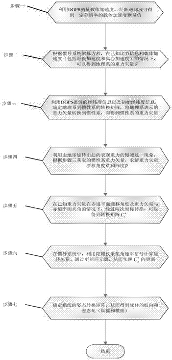
[0022] A kind of DGPS-based inertial navigation system attitude solution method of the present invention comprises the following steps:

[0023] Step 1: Use DGPS to measure the carrier acceleration, and after low-pass filtering, the carrier acceleration measurement value with a certain resolution can be obtained.

[0024] Specifically, the calculation of the carrier motion acceleration usually adopts the position differential method, that is, the carrier acceleration is obtained by performing two consecutive digital differences on the GPS carrier phase double-difference dynamic positioning results. Because GPS carrier phase observations are affected by factors such as receiver noise, multipath effects, atmospheric delays in the troposphere and stratosphere, and ephemeris errors, and the digital difference will amplify high-frequency noise, it is neces...


PUM


Abstract

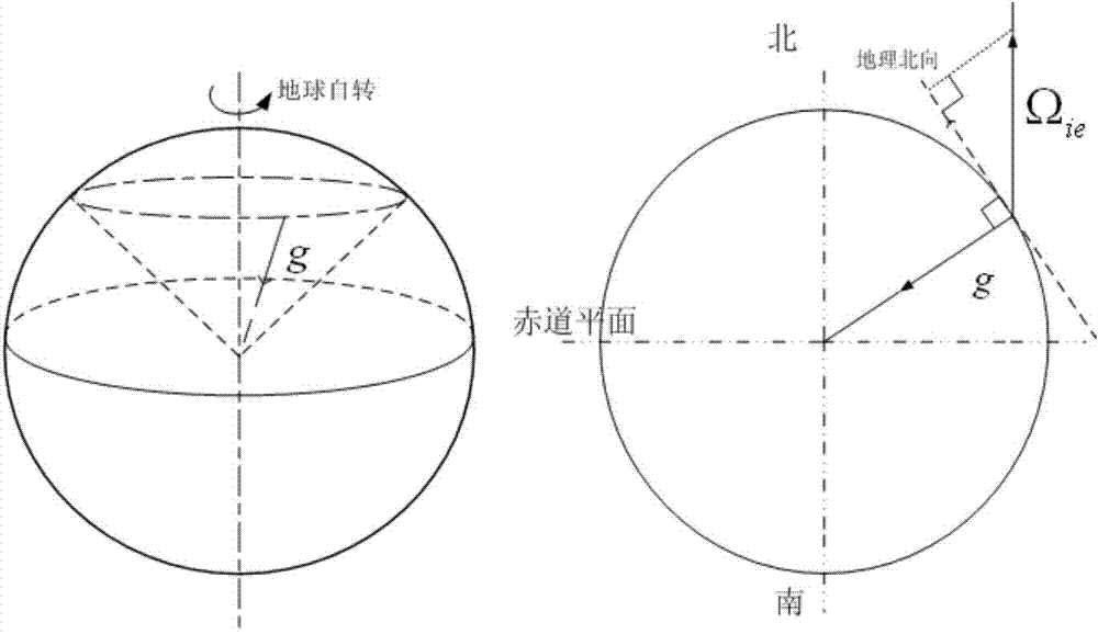
The invention provides a method for obtaining an inertial navigation system attitude based on a DGPS (differential global positioning system). The method comprises the following steps: measuring the acceleration of a carrier through the DGPS and obtaining a measured value of acceleration through low pass filtering; obtaining a gravity vector expressed in a geographical system according to a calculating equation of the inertial navigation system under the condition that specific force information and the acceleration of the carrier are known; determining the conversion matrix of an inertial system to the geographical system by using longitude and latitude information and initial longitude information provided by DGPS, and converting the gravity vector expressed in the geographical system to a gravity vector expressed in the inertial system to obtain the gravity vector expressed in the inertial system; calculating the drifting angel and latitude of the gravity vector using the gravity vector of an inertial space; obtaining a conversion matrix C_i^n after twice coordinate conversions; in the inertial navigation system, collecting angular rate signals using a gyroscope, calculating a rotating vector, updating a quaternion and updating C_b^i through the quaternion; determining an attitude conversion matrix of the system according to C_i^n and C_b^i to obtain the heading and attitude angle of the carrier, so that the accuracy of the attitude information is guaranteed to meet the requirement of ship navigation.

Description

technical field [0001] The invention belongs to the technical field of inertial navigation systems and GPS, and relates to an attitude calculation method of an inertial navigation system based on differential GPS (Differential GPS, DGPS). Background technique [0002] Inertial navigation is an autonomous dead reckoning navigation method that uses inertial sensors, reference directions, and initial positions to determine the attitude, position, and velocity of the carrier. It is not affected by the environment, carrier maneuvering and radio interference, can continuously provide all navigation parameters, and has high relative accuracy in a short period of time. It is the most important means of autonomous navigation. In the future war under the condition of informationization, navigation equipment is an important sensor, and the accuracy of navigation parameters plays a key role in winning future wars. [0003] At present, improving the accuracy of inertial devices and perf...

Claims


Application Information

Patent Timeline
IPC IPC(8): G01C21/16
CPCG01C21/165G01S19/47
Inventor 周广涛郝勤顺姜鑫赵博孙艳涛梁宏于春阳夏秀玮刘学敏金诗宇
Owner HARBIN ENG UNIV
Learn More