Land aerosol optical property retrieval method based on Gaofen-1 satellite

An optical property, aerosol technology, applied in the field of atmospheric remote sensing, can solve the problems of lack of short-wave infrared band in CCD data, difficulty in applying dark target pixels, etc.

Inactive Publication Date: 2014-07-16
INST OF REMOTE SENSING & DIGITAL EARTH CHINESE ACADEMY OF SCI
View PDF2 Cites 22 Cited by
  • Summary
  • Abstract
  • Description
  • Claims
  • Application Information

AI Technical Summary

Problems solved by technology

However, the CCD data of GF1 and other domestic satellites lack the short-wave

Method used


Image

  • Land aerosol optical property retrieval method based on Gaofen-1 satellite
  • Land aerosol optical property retrieval method based on Gaofen-1 satellite
  • Land aerosol optical property retrieval method based on Gaofen-1 satellite

Examples


Embodiment Construction

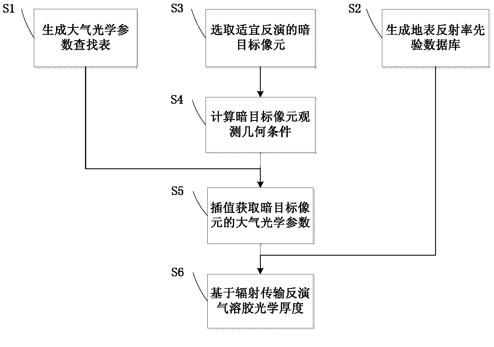
[0017] The inversion method of aerosol optical properties based on GF1 satellite wide coverage CCD data proposed by the present invention is described in detail as follows in conjunction with the accompanying drawings and examples.

[0018] Step S1, generate atmospheric optical parameter lookup table: according to different seasons and regions, based on prior knowledge of aerosol physical and chemical characteristics, determine a variety of aerosol models and atmospheric models suitable for my country; simulate and calculate different atmospheric parameters through atmospheric radiation transfer software Sol optical thickness, different observation geometric conditions, and atmospheric optical parameters corresponding to red and blue bands of GF-1 satellite wide-coverage CCD data are stored in data files to form a multi-dimensional lookup table. Step S1 specifically includes:

[0019] S11. According to aerosol sources, atmospheric conditions and seasonal changes in different re...


PUM


Abstract

The invention discloses a land aerosol optical property retrieval method based on the Gaofen-1 satellite. The land aerosol optical property retrieval method aims to solve the problem that an aerosol optical thickness retrieval method is limited by short wave infrared data, and technical supports are provided for air quality monitoring based on the domestic high-definition satellite. The land aerosol optical property retrieval method comprises the following steps that S1, an atmospheric optical parameter lookup table is generated; S2, a surface reflectance prior database is generated; S3, dark object pixels suitable for retrieval are selected; S4, the observation geometrical conditions of the dark object pixels are calculated; S5, the atmospheric optical parameters of the dark object pixels are obtained in an interpolation mode; S6, aerosol optical thickness retrieval is carried out based on radiation transfer. The method is efficient in operation, retrieval on the regional high-resolution atmospheric aerosol optical property is facilitated, and beneficial data sources are provided for particulate pollution monitoring.

Description

technical field [0001] The invention relates to the technical field of atmospheric remote sensing, in particular to a method for retrieving the optical properties of sol based on the wide-coverage CCD data of the Gaofen-1 satellite. Background technique [0002] The study of satellite remote sensing aerosols began in the mid-1970s. In the last 30 years of the last century, the satellite remote sensing aerosols used for research and operational use included volcanic eruption aerosol monitoring, NOAA (US National Oceanic and Atmospheric Administration) series satellites remote sensing of optical thickness of aerosol layers caused by sandstorms and forest fires over the deep sea, infrared remote sensing of dusty aerosol remote sensing, total ozone imaging spectrometer (TOMS) ultraviolet band detection of absorbing aerosols Several aspects of remote sensing. The Moderate Resolution Imaging Spectrometer (MODIS) carried by Terra and Aqua of the Earth Observing System Program (EOS...

Claims


Application Information

Patent Timeline
IPC IPC(8): G06F19/00
Inventor 王子峰王中挺陈良富陶金花陶明辉李莘莘张莹
Owner INST OF REMOTE SENSING & DIGITAL EARTH CHINESE ACADEMY OF SCI
Why Eureka
Try Eureka