Automatic updating processing method for increments of land utilization vector database

An incremental update, database technology, used in database update, electrical digital data processing, special data processing applications, etc.

Active Publication Date: 2014-07-23
CENT SOUTH UNIV
View PDF3 Cites 23 Cited by
  • Summary
  • Abstract
  • Description
  • Claims
  • Application Information

AI Technical Summary

Problems solved by technology

[0006] The purpose of the invention is to address the deficiencies in the prior art methods, to provide a new model and method for solving the automatic processing and quality control problems of the incremental update process of the land use (land surface coverage) vector database in the current GIS [Geographic Information System] Method: An automatic update processing method based on subdividing the topological relationship between incremental information and existing targets

Method used


Image

  • Automatic updating processing method for increments of land utilization vector database
  • Automatic updating processing method for increments of land utilization vector database
  • Automatic updating processing method for increments of land utilization vector database

Examples


Embodiment Construction

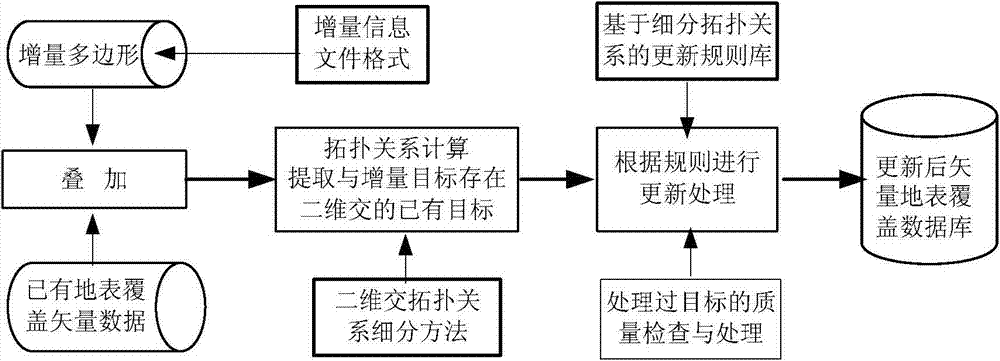
[0046] The present invention will be further described below in conjunction with the accompanying drawings and specific embodiments.

[0047] see figure 1 , the incremental information file in the figure is a change information file stored in a specific format through the direct comparison of the pixel spectral changes between the two remote sensing images or through the comparison of the first phase land use (land surface cover) map with the remote sensing image. The incremental information expression model is as follows:

[0048] I = { ∪ i = 1 m ( Δ O i , A i ) }

[0049] In the above formula, ΔO i , i∈{1,2,…m}, represents the change target (pattern), that is, the polygon in the vector model...


PUM


Abstract

The invention discloses an automatic updating processing method for increments of a land utilization vector database. The automatic updating processing method includes the steps of (1) extracting change information through remote-sensing image comparison, and storing the change information into an change-only information file according to a specific format, (2) reading in the change-only information file, calculating topological relationships between increment targets and existing land utilization land parcels, filtering out the existing land parcels which are two-dimensionally intersected with the increment targets, and calculating subdivision topological relationship types of two-dimensional intersections, (3) automatically constructing updated land parcel targets according to a land utilization increment updating processing rule based on the subdivision topological relationship types of the two-dimensional intersections, and giving corresponding characteristic attribute types, and (4) after updating processing is carried out on all the targets in the change-only information file, detecting the data quality of all the processed land parcel targets and the coincidence between the processed land parcel targets and the targets on the peripheries of the processed land parcel targets, solving corresponding problems or conflicts, generating new land utilization data, and updating the database.

Description

technical field [0001] The invention belongs to the technical field of spatio-temporal database update, and relates to an automatic method for incremental update processing of a land use (land cover / use) vector database. Background technique [0002] Since land cover directly affects the material and energy cycle process on the earth's surface, and its changes comprehensively reflect the impact of human activities and climate change on the natural environment, it has received widespread attention from the international scientific community in recent years. The current research Hotspots focus on land cover mapping, change information extraction and update, etc. [0003] ① In terms of superimposing and comparing remote sensing images and vector data to extract change target information, Zhang Jianqing et al. -666)" introduced a method for detecting changes in water systems based on remote sensing images and vector data. ③ In terms of overlaying and comparing remote sensing i...

Claims


Application Information

Patent Timeline
Patent Type & Authority Applications(China)
IPC IPC(8): G06F17/30
CPCG06F16/23G06F16/2365
Inventor 周晓光汪红松李飞吴志强李海鸥袁愈才
Owner CENT SOUTH UNIV
Why Eureka
Try Eureka