Method and system for manufacturing thematic map by fusing images based on MapGISK9

A technology of image fusion and thematic maps, applied in image enhancement, image data processing, graphics and image conversion, etc., can solve the problems of remote sensing image spectrum resolution and spatial resolution loss, and achieve the effect of high color

Inactive Publication Date: 2014-07-30
BEIJING JIAOTONG UNIV
View PDF6 Cites 9 Cited by
  • Summary
  • Abstract
  • Description
  • Claims
  • Application Information

AI Technical Summary

Problems solved by technology

[0005] The purpose of the present invention is to provide a method for making a thematic map based on MapGISK9 image fusion, aiming to solve the problem that the spectral resolution and spatial resolution of remote sensing images are missing each other

Method used


Image

  • Method and system for manufacturing thematic map by fusing images based on MapGISK9
  • Method and system for manufacturing thematic map by fusing images based on MapGISK9

Examples


Embodiment Construction

[0050] The present invention will be described in further detail below with reference to the accompanying drawings.

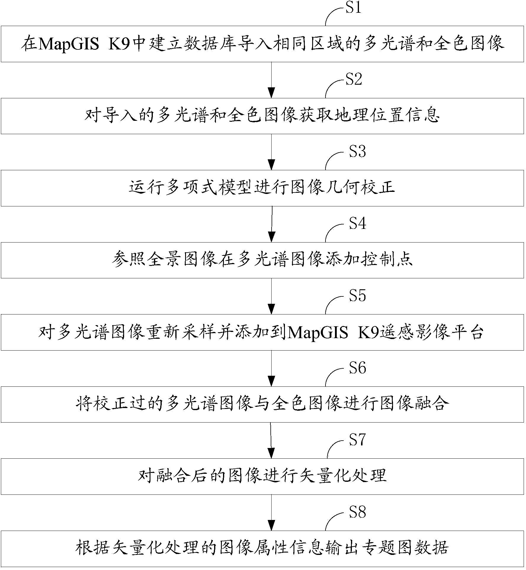
[0051] Such as figure 1 As shown, a kind of method flowchart of making thematic map based on MapGIS K9 image fusion provided by the present invention, it is described in detail as follows:

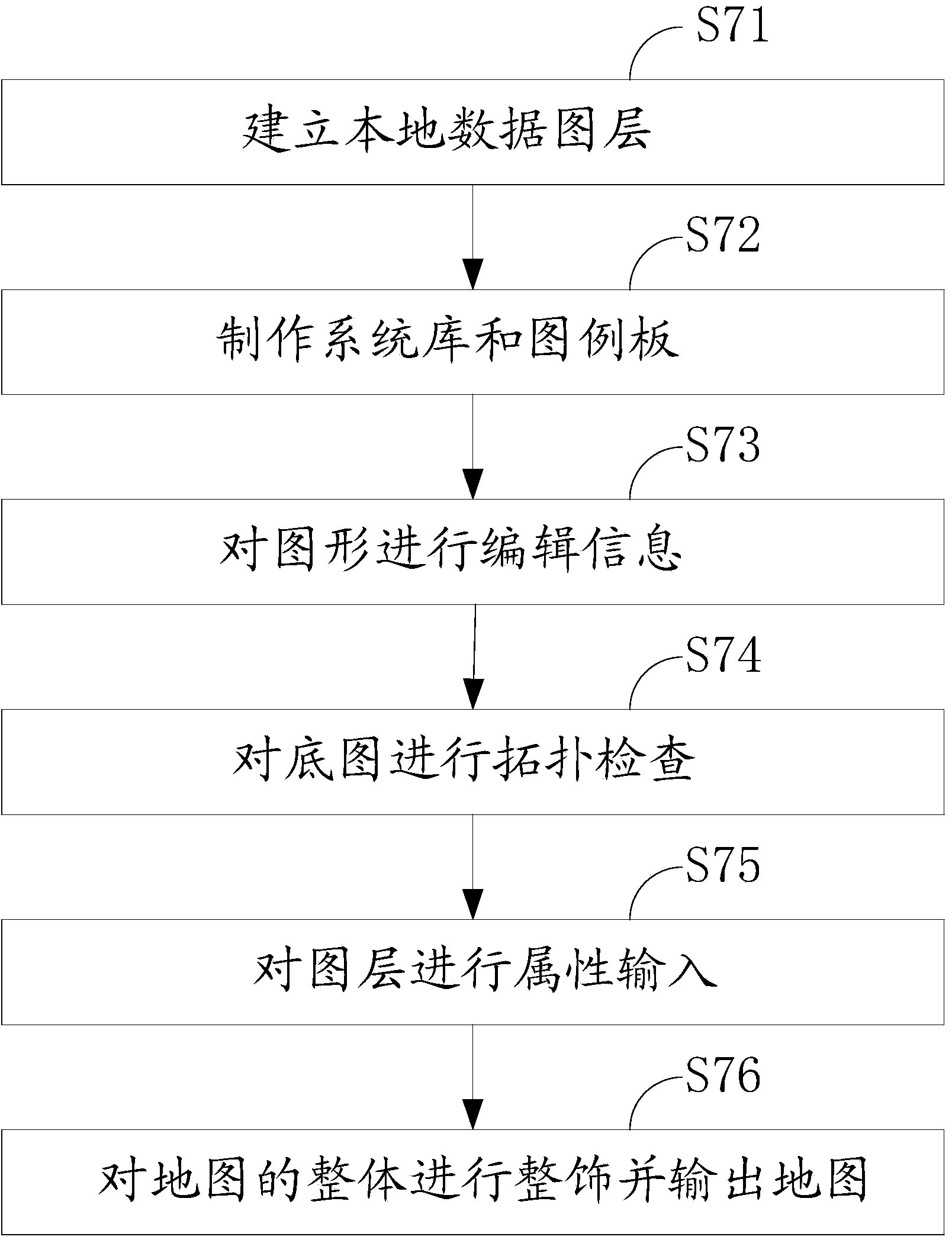
[0052] In step S1, prepare a multispectral image and a panchromatic image of the same area, build a database in MapGIS K9, import the prepared multispectral image and panchromatic image into the database, and specify the corresponding According to the specification, roads are divided into four grades, as shown in the table below.

[0053] class name

layers

color

Line Width (mm)

state Road

0

Purple

2

dart road

1

natural yellow

2

city ​​main road

2

light yellow

2

Urban secondary arterial roads and branch roads

3

black

1

[0054] In step S2, on the remote sensing image...


PUM


Abstract

The invention discloses a method and system for manufacturing a thematic map by fusing images based on the MapGISK9. The method for manufacturing the thematic map by fusing the images includes the following steps that firstly, a database is built in the MapGISK9, multispectral images and full-color images in the same area are led in; secondly, the geographical location information of the multispectral images and the full-color images which are led in is obtained; thirdly, the multispectral and images are calibrated with a MapGISK9 remote-sensing image platform; fourthly, the calibrated multispectral images and the full-color images are fused; fifthly, vectorization processing is performed on the fused images. According to the method and system for manufacturing the thematic map by fusing the images based on the MapGISK9, the multispectral images and the full-color images are fused, so that remote-sensing images have colors, the high resolution and projection information, and a series of processing of terrain classification and target identification is fully ensured.

Description

technical field [0001] The invention belongs to the field of map making, and in particular relates to a method and system for making a thematic map based on MapGI SK9 image fusion. Background technique [0002] With the rapid development of digital technology and the increasing demand, the importance of remote sensing images is becoming more and more significant, and its application fields are becoming more and more extensive. In the field of satellite remote sensing, using the respective advantages and characteristics of multiple sensors, different images collected by multiple sensors of the same target or area are fused at the pixel level, so as to provide more informative, more realistic and clearer remote sensing images. Prepare for analysis. [0003] MapGIS K9 software is the leading software in the field of geographic information systems in my country. Its advanced remote sensing data processing platform and digital mapping platform provide excellent conditions for th...

Claims


Application Information

Patent Timeline
Patent Type & Authority Applications(China)
IPC IPC(8): G06T5/50G06T3/40
Inventor 袁媛邵春福李娟
Owner BEIJING JIAOTONG UNIV
Why Eureka
Try Eureka