Multi-site point cloud integral orientation method based on laser beam process block adjustment

A technology of area network adjustment and laser beam, applied in the direction of using optical devices, measuring devices, instruments, etc., can solve the problems of lack of overall persuasion, uneven accuracy, large field workload, etc., to suppress large error scanning stations effect, precision uniform effect

Inactive Publication Date: 2014-09-03
SHANDONG UNIV OF TECH
View PDF5 Cites 21 Cited by
  • Summary
  • Abstract
  • Description
  • Claims
  • Application Information

AI Technical Summary

Problems solved by technology

The independent model method has high orientation accuracy, reasonable target distribution, and easy operation. Its shortcomings are as follows: ①Large field workload
③ The accuracy of each station is not uniform, and the overall persuasiveness is lacking in the accuracy evaluation

Method used


Image

  • Multi-site point cloud integral orientation method based on laser beam process block adjustment
  • Multi-site point cloud integral orientation method based on laser beam process block adjustment
  • Multi-site point cloud integral orientation method based on laser beam process block adjustment

Examples


Embodiment Construction

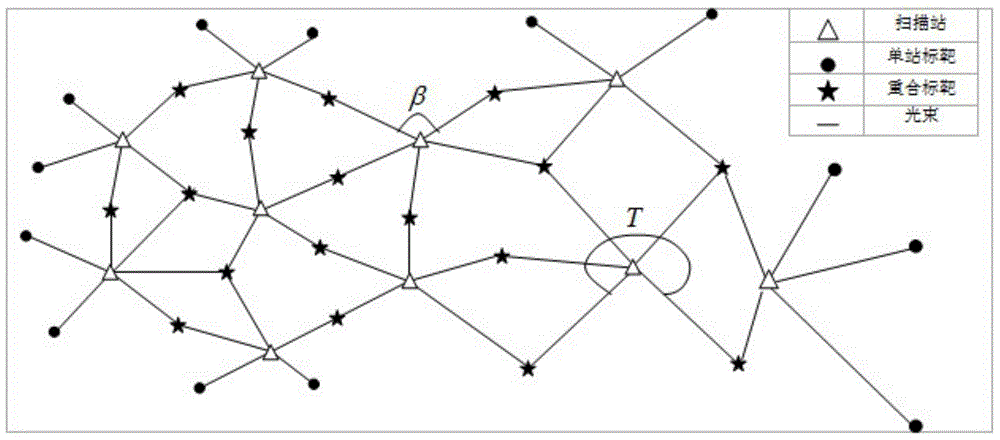
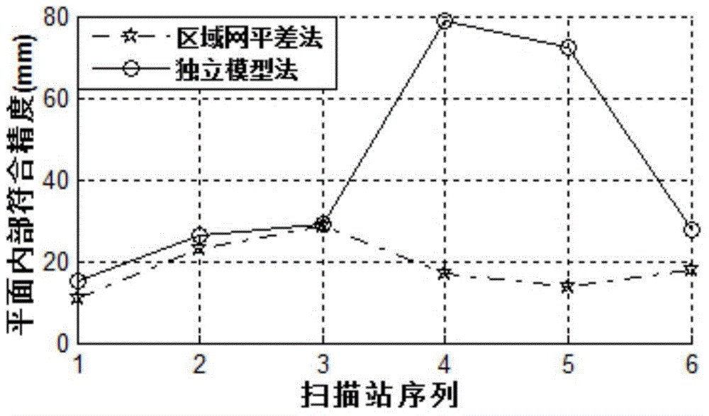
[0020] Attached below Figure 1~2 The embodiments of the present invention will be further described. In the embodiment, the area of ​​the experimental area is 0.92km*0.87km, and there are houses, pools, hills, trees, roads and other ground objects in the experimental area. The scanner used in the experiment is Riegl VZ-1000. The average distance from target to scanning station is 188m, and the average distance between scanning stations is 310m. The engineering coordinate system is the 80 Xi'an coordinate system, with the Gaussian east coordinate as X, the Gaussian north coordinate as Y, and the 85 elevation as Z, forming a right-handed three-dimensional coordinate system. The specific operation steps are:

[0021] Step 1) Select 6 scanning stations with hard soil. A total of 17 targets are arranged in the whole area. Each scanning station can observe 5-7 spherical directional targets. Adjacent scanning stations generally have 2 public targets. 3 public targets; the target...


PUM


Abstract

The invention relates to a multi-site point cloud integral orientation method based on a laser beam process block adjustment. The multi-site point cloud integral orientation method comprises the steps: 1, distributing a target in each scanning site, determining coordinates of each target center in an engineering surveying coordinate system, and forming a block; 2, performing coarse scanning on a ground feature on each scanning site, performing fine scanning on a spherical orientation target, forming an original point cloud of each scanning site, and establishing a space index of the original point cloud; 3, figuring out coordinates of the target in a scanner coordinate system of each scanning site by using a spherical fitting method; 4, making up block adjustment information; 5, firstly setting one group of error equations of laser beams for each target, if the target is a public target of N scanning sites, setting N-1 groups of constraint equations, forming an all-regional method equation by the equations, and resolving orientation parameters of all scanning sites by using a surveying adjustment summary model; 6, evaluating the point cloud orientation precision; and 7, converting point cloud coordinates of all sites into the engineering surveying coordinate system to realize multi-site point cloud integral orientation.

Description

technical field [0001] The invention relates to a multi-site cloud overall orientation method based on laser beam method area network adjustment, which belongs to the technical field of engineering measurement. Background technique [0002] The rapid development of 3D laser scanning technology enables terrestrial laser scanning to quickly and accurately obtain 3D point cloud data. Widely used in distance measurement engineering. Regardless of whether terrestrial laser scanning is used for closed single objects or for open large-scale topographic mapping, multi-station scanning with limited field of view, different viewing angles, and different spatial resolutions is required to complete object shape or surface shape measurement. The unification of multi-site cloud coordinates of the same scanning target is usually called point cloud registration, or point cloud stitching. The purpose of point cloud splicing is to unify multiple point cloud coordinate systems. For large obj...

Claims


Application Information

Patent Timeline
Patent Type & Authority Applications(China)
IPC IPC(8): G01B11/24
Inventor 姚吉利张大富刘科利马宁贾象阳徐广鹏李彩林郭宝云
Owner SHANDONG UNIV OF TECH
Why Eureka
Try Eureka