Indoor unmanned aerial vehicle positioning system

A positioning system and unmanned aerial vehicle technology, applied in the field of unmanned aerial vehicles, can solve the problems of signal sensitivity, influence, and inability to rely on GPS system positioning, etc., to achieve the effect of convenient and flexible manipulation, simple and convenient operation

Active Publication Date: 2014-09-10
DIGITAL EAGLE TECH DEV YANCHENG CO LTD
View PDF3 Cites 26 Cited by
  • Summary
  • Abstract
  • Description
  • Claims
  • Application Information

AI Technical Summary

Problems solved by technology

[0002] Most of the existing UAVs rely on the GPS system for positioning. Since the GPS system is a satellite timing system, the satellites located at high altitudes perform unified broadcast timing, and the receiver calculates the timing of multiple satellites, and then obtains the corresponding Position data, and because the transmission distance is too long, the GPS signal that can generally be received is calculated in milliwatts, so the GPS signal is easily shielded, and some common materials, such as metal and water, have the most serious impact on electromagnetic signals , Excessively thick cement walls will also have a shielding effect, so it can only be used outdoors to ensure continuous and reliable satellite signals received
When the drone is used indoors, it cannot rely on the GPS system for positioning
At the same time, because the GPS receiving system is very sensitive to signals in order to receive weak signals as much as possible, it is also easily affected by irrelevant electromagnetic signals and noise during use.

Method used


Image

  • Indoor unmanned aerial vehicle positioning system

Examples


Embodiment Construction

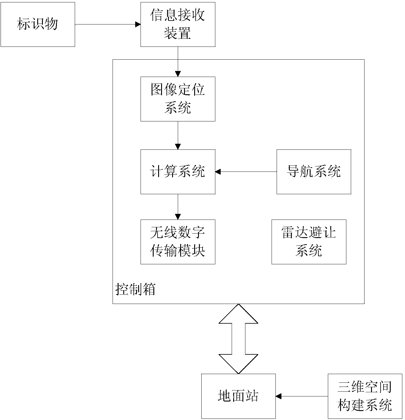
[0019] The indoor drone positioning system includes drones, markers, ground stations and three-dimensional space construction systems; the drones can be multi-rotor drones or unmanned helicopters. machine. The marker is an identification object that is clearly different from the background environment. A radio frequency device can be selected as the marker, and a visible light marker and an infrared marker can also be selected. In this embodiment, the visible light marker is selected, and the four Markers are placed on the indoor ground.

[0020] The UAV includes a control box and an information receiving device; the information receiving device is used to identify the information of the marker, and the information receiving device is different according to the specific marker. If the marker is a radio frequency device, the information receiving device is a radio frequency receiver; if the marker is a visible light marker, the information receiving device is an optical flow c...


PUM


Abstract

The invention discloses an indoor unmanned aerial vehicle positioning system. The indoor unmanned aerial vehicle positioning system comprises an unmanned aerial vehicle body, a marker, a ground station and a three-dimensional space constructing system; the unmanned aerial vehicle body comprises a control box and an information receiving device; the marker is placed in a room, when the unmanned aerial vehicle body flies, the information receiving device identifies marker information and transmits to the control box, and the control box calculates the indoor three-dimensional space coordinate information of the unmanned aerial vehicle body through combining with aircraft navigation information. By means of the three-dimensional space constructing system, the indoor three-dimensional space data is stored in the ground station, and the ground station is capable of displaying the concrete position of the unmanned aerial vehicle in the room. The indoor unmanned aerial vehicle positioning system is capable of positioning the unmanned aerial vehicle in a room in which a GPS signal is easy to be shielded, enables the unmanned aerial vehicle performance to be improved and is convenient to use the unmanned aerial vehicle in different environments.

Description

technical field [0001] The present invention relates to unmanned aerial vehicles, in particular to an indoor unmanned aerial vehicle positioning system. Background technique [0002] Most of the existing UAVs rely on the GPS system for positioning. Since the GPS system is a satellite timing system, the satellites located at high altitudes perform unified broadcast timing, and the receiver calculates the timing of multiple satellites, and then obtains the corresponding Position data, and because the transmission distance is too long, the GPS signal that can generally be received is calculated in milliwatts, so the GPS signal is easily shielded, and some common materials, such as metal and water, have the most serious impact on electromagnetic signals , Excessively thick concrete walls will also produce a shielding effect, so only when used outdoors can the received continuous and reliable satellite signals be guaranteed. When the drone is used indoors, it cannot rely on the ...

Claims


Application Information

Patent Timeline
Patent Type & Authority Applications(China)
IPC IPC(8): G01S13/86G01S5/00
CPCG01C21/206
Inventor 陈乐春
Owner DIGITAL EAGLE TECH DEV YANCHENG CO LTD
Why Eureka
Try Eureka