Urban building change detection method based on LiDAR point cloud spatial difference analysis

A technology of spatial difference and change detection, which is applied in the direction of measuring devices, electromagnetic wave re-radiation, radio wave measurement systems, etc., can solve the problems of sparse data points and missing data, and achieve the effect of improving classification accuracy and high robustness

Active Publication Date: 2014-09-17
ZHONGYUAN WISDOM CITY DESIGN RES INST CO LTD
View PDF7 Cites 43 Cited by
  • Summary
  • Abstract
  • Description
  • Claims
  • Application Information

AI Technical Summary

Problems solved by technology

At present, there are still some problems that need to be solved in LiDAR data, such as the lack of data caused by the occlusion that is not penetrated by the laser beam, the sparse data points, regional holes or data noise due to flight height, scanning angle and reflectivity of ground objects. Feature extraction and classification problems based on discrete point clouds, etc.

Method used


Image

  • Urban building change detection method based on LiDAR point cloud spatial difference analysis
  • Urban building change detection method based on LiDAR point cloud spatial difference analysis
  • Urban building change detection method based on LiDAR point cloud spatial difference analysis

Examples


Embodiment Construction

[0044] The present invention will be further described below with reference to the drawings and embodiments.

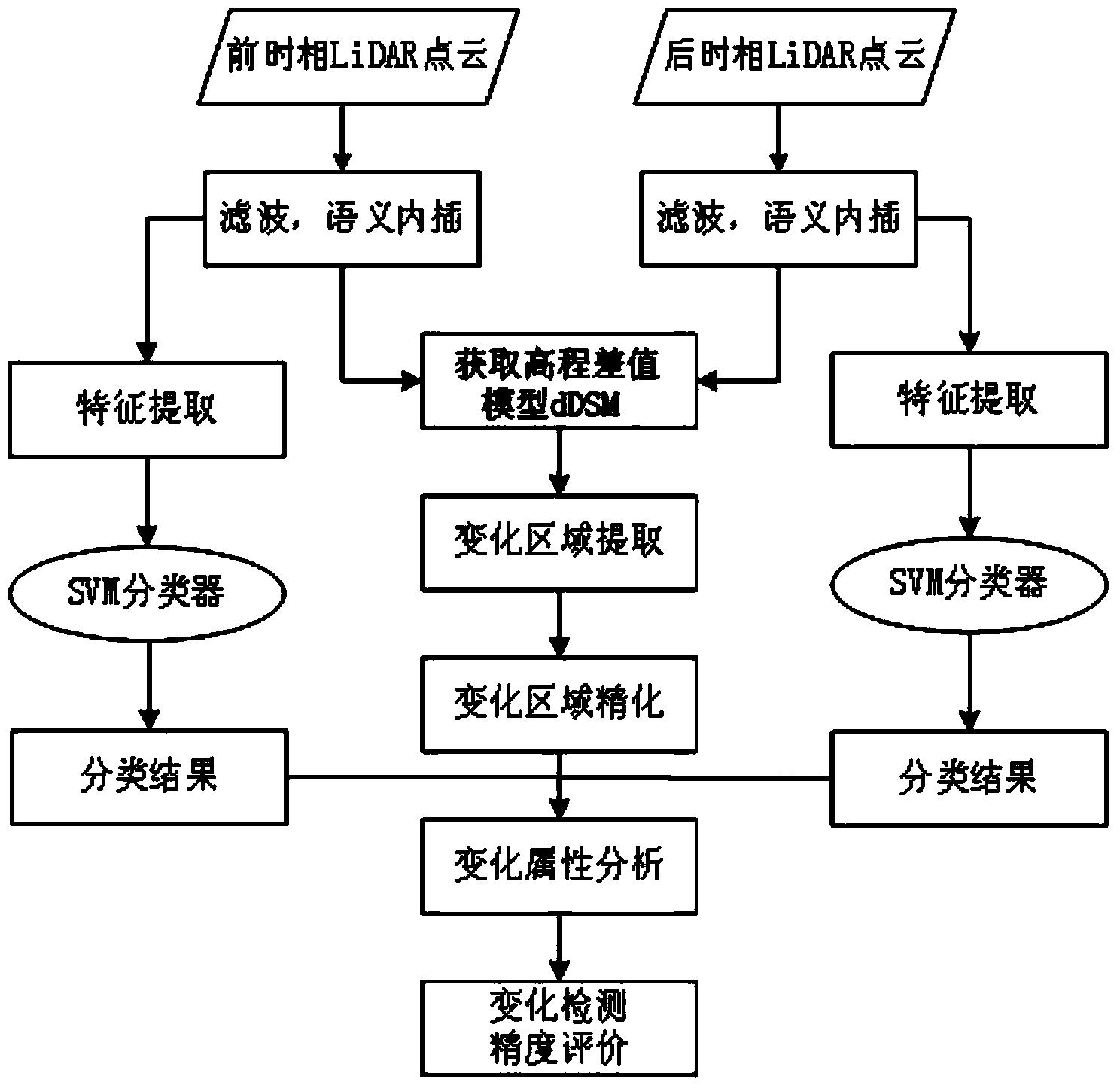
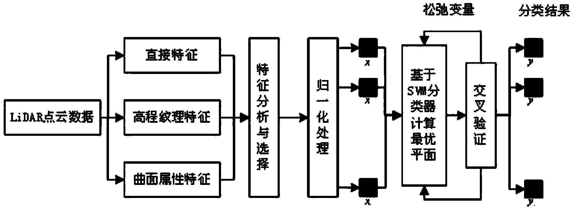
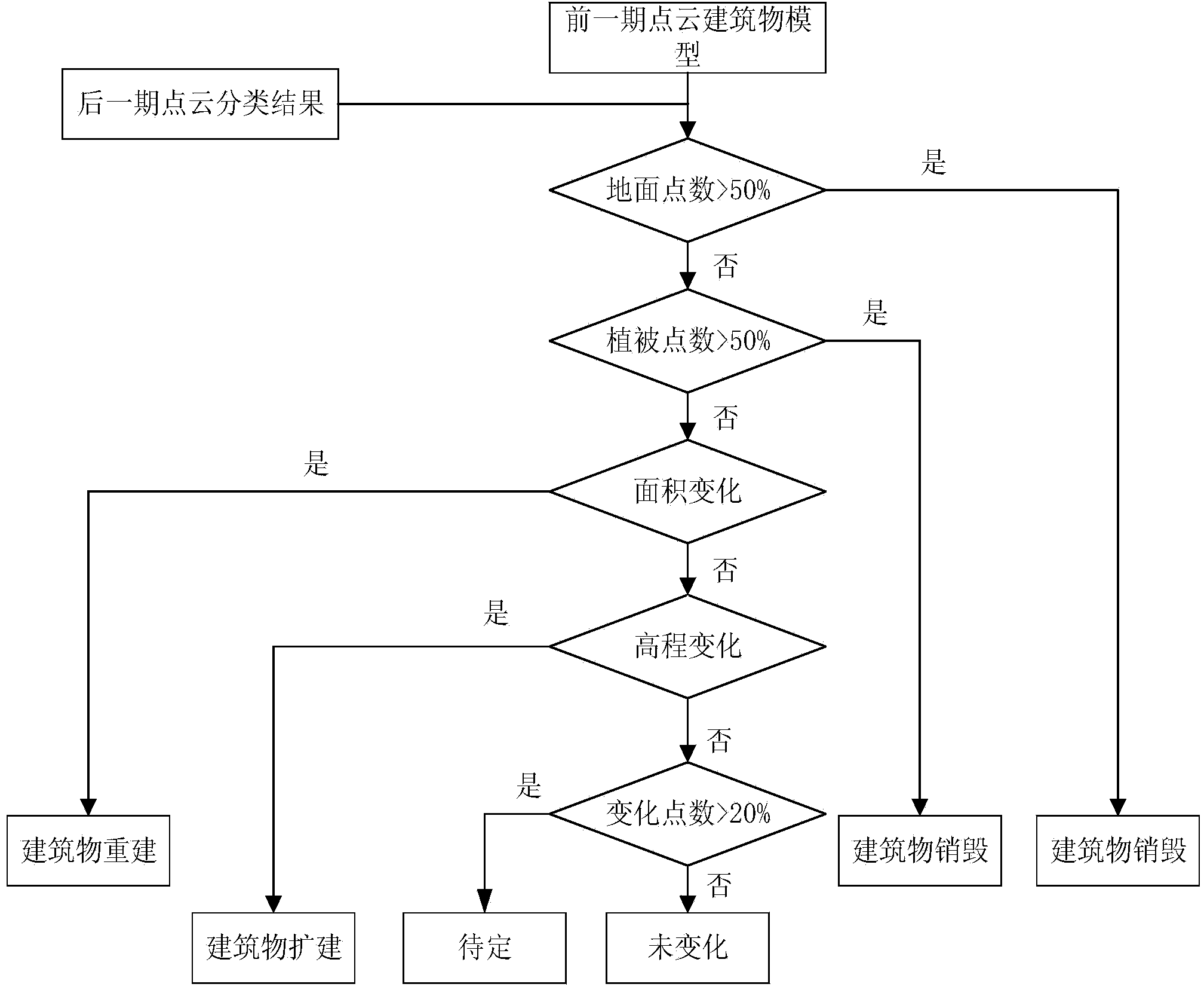
[0045] Such as figure 1 As shown, the present invention first determines the candidate change area by analyzing the spatial differences of point clouds at different time phases. Then take the candidate change area as a constraint, introduce the SVM algorithm to realize the automatic classification of multi-temporal point clouds; improve the classification accuracy by extracting the LiDAR point cloud texture features and local geometric features; finally, combine the classification results and the spatial analysis results to analyze the building change attributes . Specific steps are as follows:

[0046] Step 1: First, preprocess the point cloud data, including steps such as denoising and filtering. On this basis, linear interpolation algorithm is used to rasterize the point cloud data to obtain DSM and DTM in different time phases. Next, use formula (1) to remove the to...


PUM


Abstract

The invention discloses an urban building change detection method based on LiDAR point cloud spatial difference analysis. The method comprises the steps that 1, LiDAR point cloud data with different time phases are respectively preprocessed, and DSM and DTM of the different time phases are obtained through a linear interpolation algorithm; 2, two periods of the DSM obtained in the step 1 are subtracted to obtain an elevation difference model; 3, spatial difference analysis is carried out on the elevation difference model, and a candidate change area is extracted; 4, spatial features of a LiDAR point cloud are used for extracting direct features and elevation grain features; 5, building and vegetation classification is achieved; 6, superposition and overlay analysis is carried out on the candidate change area, and the building change attribute is determined. The advantages of the LiDAR data on three-dimensional representation of the building complex structure and the topological relation are fully achieved, and building three-dimensional change detection is carried out.

Description

Technical field [0001] The present invention relates to the technical field of airborne lidar, in particular to a method for detecting changes in urban buildings based on LiDAR point cloud spatial difference analysis. Background technique [0002] With the continuous development of economic construction, my country's urban construction is in full swing, and urban changes are very frequent and intense. Remote sensing (including aerial) images have high geometric accuracy and rich semantic information. They are currently the largest data source for large-scale and high-frequency urban change detection. In recent decades, many scholars have conducted in-depth research on change detection based on remote sensing images, put forward many representative algorithms, and formed a rich theoretical system. However, the current remote sensing image-based change detection still faces many problems such as occlusion and shadow, poor projection, internal heterogeneity of features, excessive t...

Claims


Application Information

Patent Timeline
Patent Type & Authority Applications(China)
IPC IPC(8): G01S7/48
CPCG01S7/4802G01S17/88
Inventor 陈长宝谢兴张玉卢志渊杜红民刘会娟肖丹丹
Owner ZHONGYUAN WISDOM CITY DESIGN RES INST CO LTD
Why Eureka
Try Eureka