Multi-resource remote sensing distinguishing method and system of underground potassium- and halide-containing water resource in salt lake area

A technology of water resources and remote sensing, applied in the field of remote sensing technology and application, can solve the problems that remote sensing image data cannot mutually verify the recognition accuracy, and the application effect is not ideal

Active Publication Date: 2014-10-29
INST OF MINERAL RESOURCES CHINESE ACAD OF GEOLOGICAL SCI
View PDF3 Cites 25 Cited by
  • Summary
  • Abstract
  • Description
  • Claims
  • Application Information

AI Technical Summary

Problems solved by technology

[0006] The present invention aims at the prior art by combining geological interpretation of multi-spectral remote sensing image data and multi-spectral structure interpretation to carry out remote sensing research on underground potassium-containing brine resources. The image data cannot be mutually verified and the identification accuracy is low. A multi-source remote sensing identification method for underground potassium-containing brine resources in the salt lake area is provided. Through the processing, interpretation and integration of multi-source remote sensing image data, underground potassium-containing brine resources can be realized. accurate discrimination of

Method used


Image

  • Multi-resource remote sensing distinguishing method and system of underground potassium- and halide-containing water resource in salt lake area
  • Multi-resource remote sensing distinguishing method and system of underground potassium- and halide-containing water resource in salt lake area
  • Multi-resource remote sensing distinguishing method and system of underground potassium- and halide-containing water resource in salt lake area

Examples


Embodiment Construction

[0039] The present invention will be described below in conjunction with the accompanying drawings.

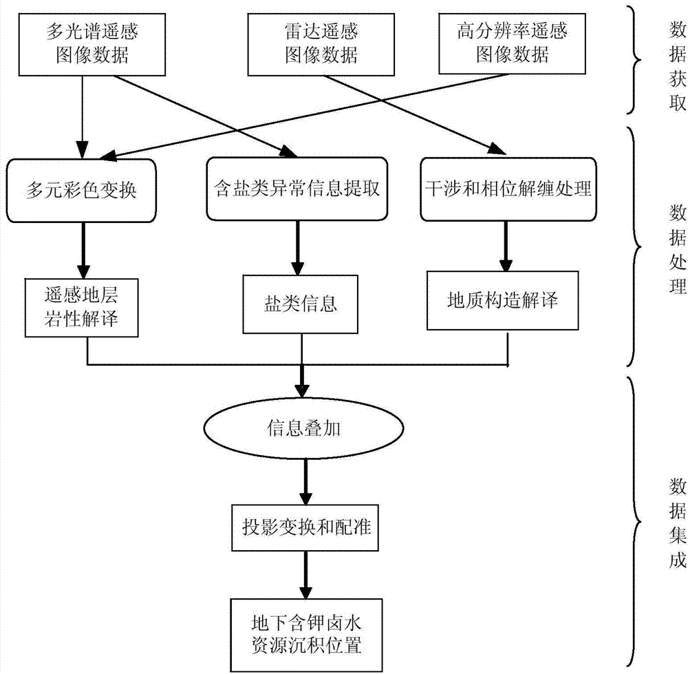
[0040] The invention relates to a multi-source remote sensing discrimination method suitable for underground potassium-containing brine resources in salt lake areas, the flow chart of which is as follows figure 1 shown, including the following steps:

[0041] The data acquisition step is used to acquire multi-source remote sensing image data, the multi-source remote sensing image data including multi-spectral remote sensing image data, radar remote sensing image data and high-resolution remote sensing image data;

[0042] Data processing steps, including multi-spectral remote sensing image data and high-resolution remote sensing image data through multivariate color transformation technology to highlight the useful information in the image data and clarify the differences in spectral features between different ground objects, and establish remote sensing formation lithology in...


PUM


Abstract

The invention relates to a multi-resource remote sensing distinguishing method and system of an underground potassium- and halide-containing water resource in a salt lake area. The method comprises the following steps: acquiring data, namely, acquiring multi-resource remote sensing image data; processing data, namely, processing multi-spectral remote sensing image data and high-resolution remote sensing image data by the multi-color transformation technology, building a remote sensing stratum lithology interpretation mark and performing remote sensing stratum lithology interpretation; extracting salt-containing abnormality information from the multi-spectral remote sensing image data by the main component analyzing technology; extracting the salt information by the interpretation extracting method; processing a radar remote sensing image data, building a geologic structure interpretation mark for potassium- and halide-containing water resource and performing geologic structure interpretation; integrating data, namely, processing three information obtained in data processing by overlapping, projection transformation and matching. According to the method, the multi-resource remote sensing image data are processed, interpreted and integrated to realize accurate distinguishing of the potassium- and halide-containing water resource.

Description

technical field [0001] The invention relates to the field of remote sensing technology and application, in particular to a multi-source remote sensing identification method and system suitable for underground potassium-containing brine resources in salt lake areas. Background technique [0002] Remote sensing technology is a high-tech, used for non-contact detection of material information on the earth's surface and a certain depth, applying remote sensing to geology, using remote sensing with large angle, large field of view, rich information, timing positioning, macro observation, multi-band , strong three-dimensional sense, obvious topographic and geomorphic features, etc., study the electromagnetic radiation reflection characteristics of geological bodies and geological phenomena on the earth's surface and surface layers, and identify the nature of geological bodies and geological phenomena, so as to provide a basis for the study of geological structures, geological mappi...

Claims


Application Information

Patent Timeline
Patent Type & Authority Applications(China)
IPC IPC(8): G06K9/62G06K9/46G06T7/00G01S17/89
Inventor 姚佛军焦鹏程刘雷震
Owner INST OF MINERAL RESOURCES CHINESE ACAD OF GEOLOGICAL SCI
Why Eureka
Try Eureka