Urban vehicle navigation positioning method based on road lamp assistant positioning

A vehicle navigation and auxiliary positioning technology, applied in the field of urban vehicle navigation technology, can solve the problems of long communication time and difficult positioning, achieve the effect of small amount of communication data, short time consumption, and improve position accuracy

Inactive Publication Date: 2014-12-10
孙亚飞
View PDF7 Cites 22 Cited by
  • Summary
  • Abstract
  • Description
  • Claims
  • Application Information

AI Technical Summary

Problems solved by technology

The current road sign positioning needs to arrange road mark points in the city, and it takes a long communication time to obtain the complete location information of the road signs. If the vehicle is traveling at a fast speed, it is often difficult to locate

Method used


Image

  • Urban vehicle navigation positioning method based on road lamp assistant positioning
  • Urban vehicle navigation positioning method based on road lamp assistant positioning

Examples


Embodiment Construction

[0026] The present invention will be further described below in conjunction with the accompanying drawings.

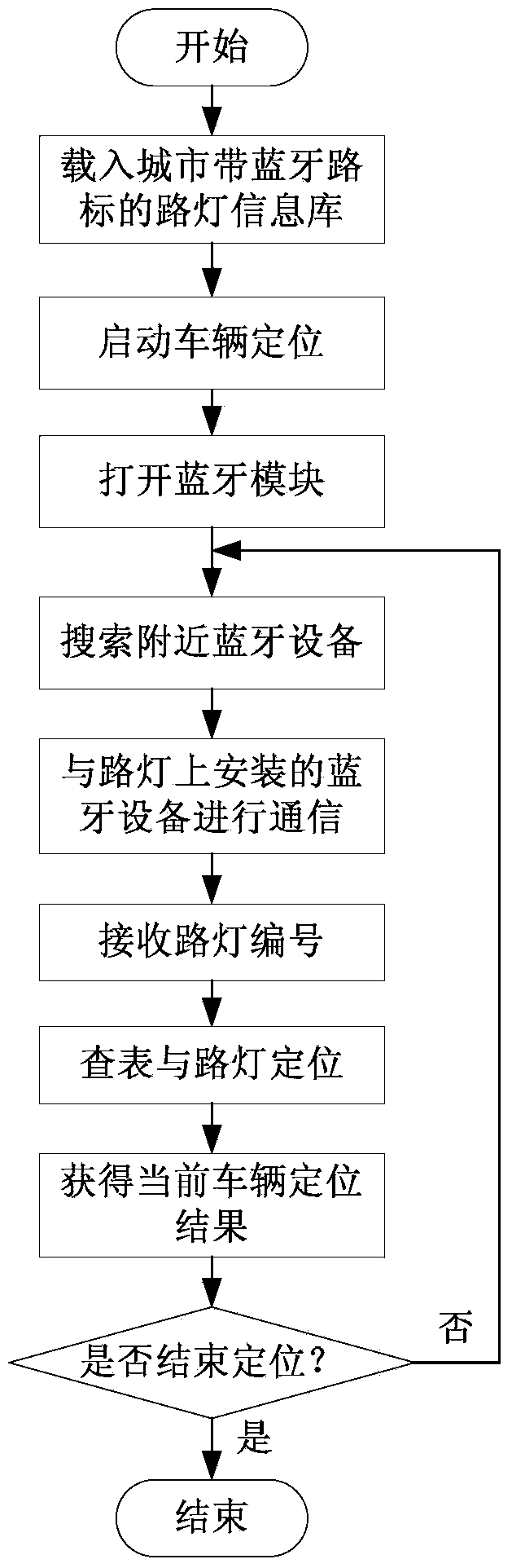
[0027] like figure 1 Shown is a city vehicle navigation positioning method based on street lamp assisted positioning, including the following steps:

[0028] (1) Select some or all of the street lamps on both sides of the road as road signs, and install Bluetooth devices on these street lamps that can provide the current street lamp ID number, and establish a database of the correspondence between the street lamp ID number and the street lamp geographic location;

[0029] (2) load the database that step (1) establishes in the vehicle-mounted navigation system of vehicle;

[0030] (3) The car navigation system turns on the bluetooth communication function, searches for the bluetooth device that can establish a connection, and communicates with the bluetooth device that can establish a connection with the strongest signal to obtain the street lamp ID number;

[0031] (...


PUM


Abstract

The invention discloses an urban vehicle navigation positioning method based on road lamp assistant positioning. According to the method, road lamps on both sides of an urban road are taken as navigation positioning reference road signs, and the IDs of the road lamps are numbers in order that each road lamp ID number corresponds to one piece of fixed position information; meanwhile, wireless communication equipment is arranged on the road lamps, the ID number of the road lamp which is nearest to a vehicle passing by is acquired through Bluetooth communication, the position information of the road lamp can be acquired by inquiring a road lamp position database, and navigation is performed by taking the position of the road lamp as the position of the vehicle. Through adoption of the method, accurate positioning can be realized when the vehicle runs in a tunnel or a road beside which high buildings exist even though a satellite navigating signal is shielded; moreover, only Bluetooth equipment needs to be arranged on a portion of urban road lamps in cities, the modification amount is small; the Bluetooth equipment only needs to provide the number of the road lamp on which the Bluetooth equipment is positioned, thereby realizing small communication data side, low time consumption and adaptability to high running speeds of vehicles.

Description

technical field [0001] The invention relates to an urban vehicle navigation positioning method based on street lamp auxiliary positioning, which belongs to the urban vehicle navigation technology. Background technique [0002] Existing vehicle navigation systems are generally equipped with GPS receivers, which can obtain navigation information such as longitude, latitude, and height of vehicles in real time by receiving GPS satellite signals, and display them on digital maps. However, as there are more and more high-rise buildings, mountain tunnels and viaducts in the city, vehicles often encounter situations where GPS satellite signals are blocked and it is difficult to provide effective positioning information when driving on the road. In consideration of the above situation, on the basis of GPS positioning, dead reckoning (DR), map matching (Map Matching, MM) and other methods are often used to assist vehicle navigation and positioning. [0003] Literature (Jin Lianglian...

Claims


Application Information

Patent Timeline
Patent Type & Authority Applications(China)
IPC IPC(8): G01S1/02
CPCG01S1/02
Inventor 孙亚飞
Owner 孙亚飞
Why Eureka
Try Eureka