MeanShift based high-resolution remote sensing image segmentation distance measurement optimization method

A high-resolution, distance measurement technology, applied in image analysis, image data processing, instrumentation, etc., to solve the problem of low segmentation image accuracy

Inactive Publication Date: 2014-12-10
ZHEJIANG UNIV OF TECH
View PDF2 Cites 9 Cited by
  • Summary
  • Abstract
  • Description
  • Claims
  • Application Information

AI Technical Summary

Problems solved by technology

[0005] The present invention overcomes the shortcoming of low accuracy when segmenting images in the prior art, and provides a MeanShift-based high-resolution remote sensing image segmentation distance measurement optimization method

Method used


Image

  • MeanShift based high-resolution remote sensing image segmentation distance measurement optimization method
  • MeanShift based high-resolution remote sensing image segmentation distance measurement optimization method
  • MeanShift based high-resolution remote sensing image segmentation distance measurement optimization method

Examples


Embodiment Construction

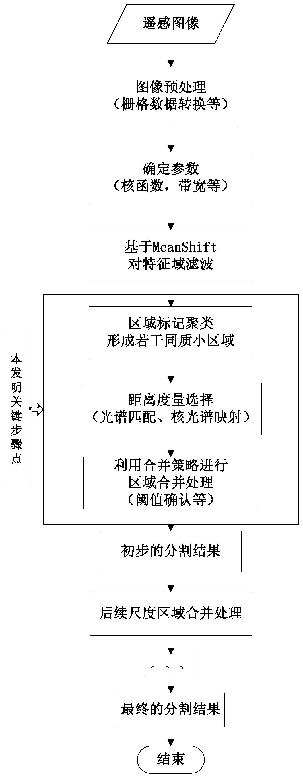
[0040] According to accompanying drawing, further set forth the present invention:

[0041] A method for optimizing the distance measurement of high-resolution remote sensing image segmentation based on MeanShift, including the following steps:

[0042] 1) Input high-resolution remote sensing images and convert them into raster data for processing;

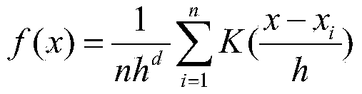
[0043] 2) Use the MeanShift algorithm to filter the remote sensing image, and obtain a large number of homogeneous regions centered on the model point;

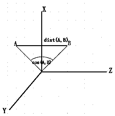
[0044] 3), after filtering, a large number of homogeneous regions are merged, and the similarity between regions is calculated, and the traditional Euclidean distance metric calculation method is replaced by a spectral matching metric calculation method or a nuclear spectral mapping metric calculation method;

[0045] 4) Set an appropriate threshold to judge the similarity measure of the two regions, and initially form the segmentation result. In the further scale region merging...


PUM


Abstract

The invention discloses a MeanShift based distance measurement optimization method in high-resolution remote sensing image segmentation during area merging. According to the MeanShift based high-resolution remote sensing image segmentation distance measurement optimization method, remote sending image data characteristics are fully considered, traditional Euclidean distance is replaced by spectrum matching distance measurement, specifically, spectrum angle matching measurement, spectral similarity measurement and Kernel mapping spectrum matching measurement, and the segmentation result is accurate.

Description

technical field [0001] In the field of high-resolution remote sensing image processing, the invention aims at the remote sensing image segmentation technology based on the MeanShift algorithm, and optimizes the distance measurement calculation involved in the region merging process, so as to further obtain an image segmentation effect with higher precision. Background technique [0002] With the development of remote sensing technology, high-resolution remote sensing images have been widely used in many fields. Since high-resolution remote sensing images have richer spectral bands, more detailed terrain structure and other data information, the requirements for remote sensing image processing technology have also been continuously improved. Image segmentation technology is an object-oriented high-resolution remote sensing image information extraction and It is one of the important steps of analysis, and its segmentation quality directly determines the accuracy of subsequent ...

Claims


Application Information

Patent Timeline
Patent Type & Authority Applications(China)
IPC IPC(8): G06T7/00
Inventor 王卫红徐文涛夏列钢
Owner ZHEJIANG UNIV OF TECH
Why Eureka
Try Eureka