Intelligent terminal navigation application system and navigation application method thereof

An application system and intelligent terminal technology, applied in navigation, surveying and mapping and navigation, road network navigator, etc., can solve problems such as high probability of error, failure to use normally, and reduced positioning accuracy

Inactive Publication Date: 2015-01-14
SHENZHEN ZHONGKEWU SOFTWARE
View PDF4 Cites 1 Cited by
  • Summary
  • Abstract
  • Description
  • Claims
  • Application Information

AI Technical Summary

Problems solved by technology

[0004] At present, although navigation modules (such as GPS) are widely used in navigation and positioning, because their signals are often blocked by terrain and objects, the accuracy of positioning is reduced, and sometimes there is no signal at all in the signal blank area, resulting in malfunction. use
Especially in large cities with high-rise buildings or forest areas with dense vegetation, the effectiveness of navigation and positioning signals is low
And in the case of static, GPS can not give positioning information
Moreover, a single GPS global positioning system cannot identify different vertical heights on a coordinate, resulting in a relatively high probability of error

Method used


Image

  • Intelligent terminal navigation application system and navigation application method thereof

Examples


Embodiment Construction

[0017] The present invention will be further described in detail below in conjunction with the drawings and specific embodiments of the present invention.

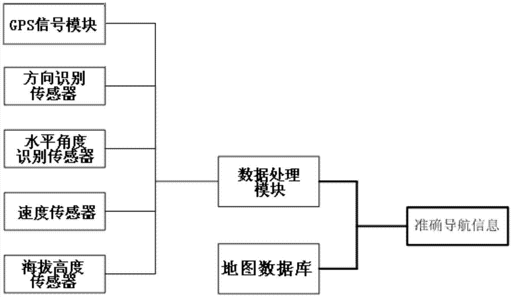
[0018] Please refer to the attached figure 1 : the present invention proposes a kind of intelligent terminal navigation application system for above situation, this intelligent terminal navigation system combines other sensors, carries out effective compensation and supplement to GPS positioning signal, realizes seamless positioning, and can carry out under the normal situation of GPS signal Further optimize navigation for positioning accuracy.

[0019] The intelligent terminal navigation application system includes a map database, a GPS signal module, a sensor module and a data processing module, and the sensor module includes a direction recognition sensor, a horizontal angle recognition sensor, a speed sensor, and an altitude sensor; the sensor module and the GPS signal module signal Connect to the data processing modu...


PUM


Abstract

The invention discloses an intelligent terminal navigation application system which comprises a map database, a GPS signal module, a sensor module and a data processing module, wherein the sensor module comprises a direction recognition sensor, a horizontal angle recognition sensor, a speed sensor and an altitude height sensor, wherein the sensor module and the GPS signal module are in signal connection to the data processing module; signals gathered by the data processing module are combined with the map database and are positioned on a map. The intelligent terminal navigation application system is provided with various sensors; therefore, under a condition that a satellite signal is relatively weak, navigation and positioning are carried out by other positioning measures; furthermore, under a condition of a loaded indoor map and a map of a large-size industrial park, a speed sensor and the altitude height sensor can be seamlessly connected to obtain accurate navigation information.

Description

【Technical field】 [0001] The invention relates to precise navigation and positioning technology, which is compatible with multiple positioning technologies and path calculation schemes, and particularly relates to precise positioning and navigation systems for azimuth, route, speed, height, and travel route in buildings. 【Background technique】 [0002] In the process of large-scale and super-large cities, the traffic network between cities, the city, and the scale of the city are constantly becoming larger and more complex. Once you need to go to an unfamiliar place, you are faced with the problem of not being able to choose the best route, not being able to Accurately find the trouble of the target location. [0003] In order to help people identify roads and plan routes, smart electronic devices can download maps and find locations. In order to better guide the plan, the integrated navigation module will be used on the portable smart device to track and locate at any time...

Claims


Application Information

Patent Timeline
Patent Type & Authority Applications(China)
IPC IPC(8): G01C21/00G01C21/16G01S19/48
CPCG01C21/005G01C21/28
Inventor 须成忠刘进
Owner SHENZHEN ZHONGKEWU SOFTWARE
Why Eureka
Try Eureka