Unmanned aerial vehicle multi-overlapped-remote-sensing-image method for extracting building contour line

A technology of remote sensing image and extraction method, which is applied in image analysis, image data processing, computer components, etc., can solve the problems of small size of stereoscopic images and the influence of large-scale extraction of urban building outlines, and achieve the effect of improving accuracy

Active Publication Date: 2015-04-01
WUHAN UNIV
View PDF4 Cites 75 Cited by
  • Summary
  • Abstract
  • Description
  • Claims
  • Application Information

AI Technical Summary

Problems solved by technology

However, the problem with this type of method is that the stereo image has a small format, which has a certain impact on the extraction of large-scale urban building outlines.

Method used


Image

  • Unmanned aerial vehicle multi-overlapped-remote-sensing-image method for extracting building contour line
  • Unmanned aerial vehicle multi-overlapped-remote-sensing-image method for extracting building contour line
  • Unmanned aerial vehicle multi-overlapped-remote-sensing-image method for extracting building contour line

Examples


Embodiment Construction

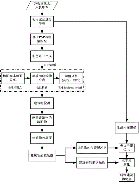
[0090] The present invention proposes a method for extracting building outlines from UAV remote sensing images. The method first utilizes the aerial triangulation algorithm in photogrammetry combined with multi-view geometric stereo reconstruction in computer vision to quickly generate a three-dimensional point cloud with geographic coordinates. , and then extract the rough outline information of the building through 3D point cloud segmentation, build the rough outline information of the building into a buffer zone and superimpose it on the high-resolution image, and then use the rough outline as the prior shape information in the buffer zone The level set is evolved and iterated to obtain the precise geometric outline of the building. Since 3D point clouds are generated by dense matching of images, there are no registration difficulties between point clouds and images. Below in conjunction with accompanying drawing and embodiment describe in detail the technical scheme of the...


PUM


Abstract

The invention discloses an unmanned aerial vehicle multi-overlapped-remote-sensing-image method for extracting a building contour line. The unmanned aerial vehicle multi-overlapped-remote-sensing-image method includes the steps that three-dimensional point cloud is generated with an aerial-triangulation and dense-matching combined method and filtered, and a building is detected from the point cloud; after the walls of the detected building are canceled, the general contour of the building is extracted from building top face information; the general contour of the building serves as a buffering area to be overlapped on spliced images and serves as shape prior information, evolution is carried out in the buffering area with a level set algorithm, and finally an accurate contour of the building is obtained. By means of the unmanned aerial vehicle multi-overlapped-remote-sensing-image method, as point cloud three-dimensional information generated by the multiple overlapped images is sufficiently used, and meanwhile the high-accuracy geometrical information of the high-resolution remote sensing images is used in a combined mode, the building contour extracting accuracy is remarkably improved, and the complexity of the method is lowered.

Description

technical field [0001] The invention relates to the technical field of remote sensing image applications, in particular to a method for extracting building contours from drone remote sensing images. Background technique [0002] Buildings are an important geospatial element in cities, and they are of great significance in the application fields of urban planning and management, urban development and change, and disaster detection and assessment. Building outline extraction is an important step in the establishment and update of urban basic geographic information system. As a new type of remote sensing monitoring platform, unmanned aerial vehicle (UAV) has a high degree of intelligence in flight operation. It can fly autonomously and take pictures according to the predetermined route, and provide remote sensing monitoring data and low-altitude video monitoring in real time. It has the characteristics of strong mobility, convenience, and low cost. The obtained high-resolution...

Claims


Application Information

Patent Timeline
Patent Type & Authority Applications(China)
IPC IPC(8): G06K9/46G06T7/00
Inventor 眭海刚涂继辉贾曲宋志娜陈光徐川
Owner WUHAN UNIV
Why Eureka
Try Eureka