Urban garden digital system and site selection method

A garden and city technology, applied in image data processing, data processing applications, instruments, etc., can solve problems such as inability to guide digital garden construction, and achieve the effect of fast processing speed, good effect, and improved accuracy

Active Publication Date: 2015-04-08
住房和城乡建设部城乡规划管理中心
View PDF1 Cites 19 Cited by
  • Summary
  • Abstract
  • Description
  • Claims
  • Application Information

AI Technical Summary

Problems solved by technology

[0005] At present, 3S information technology has already been applied in the landscaping industry at home and abroad, but many landscaping GIS systems are only limited to shallow applications such as data query and display, and cannot guide the construction of digital gardens.

Method used


Image

  • Urban garden digital system and site selection method
  • Urban garden digital system and site selection method
  • Urban garden digital system and site selection method

Examples


Embodiment 1

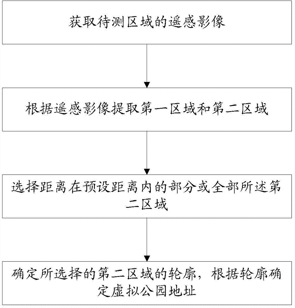
[0082] In this embodiment, a method for digital site selection of urban gardens is provided, which is used for site selection of urban gardens during the construction of urban digital gardens, including the following process:

[0083] S1. Obtain remote sensing images of the area to be measured. Image data captured by satellites can be used.

[0084] S2. Extracting a first area and a second area according to the remote sensing image, the first area is an area covered by park green space, and the second area is a residential land area outside the area covered by park green space.

[0085] In this step, the extraction of the green area of ​​the park includes two parts. The first step is to obtain the green area of ​​the park, and then the area covered by the green area of ​​the park is obtained by extending the edge of the green area of ​​the park. The specific process is as follows:

[0086] S21. Process the remote sensing image. Through the processing of remote sensing images...

Embodiment 2

[0131] In this embodiment, a method for digital site selection of urban gardens is provided, which is used in the digital management system of urban gardens, using geographic information systems (GIS), remote sensing (RS), global positioning systems (GPS), databases, MIS, OA and other spaces Information technology, the establishment of landscaping basic database, combined with landscaping professional knowledge and experience, to realize the collection and storage of landscaping data, landscaping planning and design, construction, maintenance management, management of parks and scenic spots, landscaping water saving, OA office, Digital, networked, visualized, automated and intelligent technical systems for the whole process of e-government, Web information distribution, etc., realize the integrated management of garden information data, provide scientific basis for administrative decision-making, and improve the construction of digital city infrastructure.

[0132] In this embo...


PUM


Abstract

The invention provides an urban garden digital system and a site selection method. Satellite remote sensing images are utilized for analysis, park green land coverage area and residential land area apart from the park green land coverage area are extracted according to the remote sensing images, and a virtual park address is confirmed according to the contour of the residential land area which is not covered. Therefore, park green land information can be objectively and visually acquired via the images, and the area which is not covered can be conveniently extracted for guidance of park side selection so that basis is provided for park site selection, basis is provided for realization of better urban greening, complicated workload of artificial measurement and statistics is greatly reduced, misjudgment caused by artificial subjective factors can be reduced and accuracy is enhanced.

Description

technical field [0001] The invention relates to the field of urban greening, in particular to a digital system for urban gardens and a site selection method. Background technique [0002] Urban green space is an important infrastructure in the city and an important part of the urban ecosystem. It plays an active role in improving the urban ecological environment and maintaining the harmonious coexistence between man and nature. The ecological effect of urban green space is closely related to its own spatial distribution pattern in the city. In order to give full play to the role of urban green space as an "urban cleaner", it is necessary to rationally plan, construct and manage urban green space, and to grasp the urban environment objectively and accurately. Changes in green space. [0003] At present, many experts and scholars in the industry apply GIS technology to many aspects of urban green space research. Research in this area abroad started relatively early. Since th...

Claims


Application Information

Patent Timeline
Patent Type & Authority Applications(China)
IPC IPC(8): G06Q50/00G06T5/00G06T7/00
Inventor 张晓军师卫华许士翔蔡文婷李倩张芳
Owner 住房和城乡建设部城乡规划管理中心
Why Eureka
Try Eureka