Remote sensing inversion method and system for land cloud optical thickness

A cloud optical thickness and remote sensing inversion technology, applied in the field of atmospheric remote sensing, can solve the problems of difficult ice cloud inversion, large changes in time and space distribution, and inaccurate conclusions about clouds

Inactive Publication Date: 2015-04-22
INST OF REMOTE SENSING & DIGITAL EARTH CHINESE ACADEMY OF SCI
View PDF4 Cites 29 Cited by
  • Summary
  • Abstract
  • Description
  • Claims
  • Application Information

AI Technical Summary

Problems solved by technology

[0005] At present, there are still some problems in the accuracy of cloud optical depth sensed by satellite remote sensing. The most important problem is that the degree of influence of cloud macroscopic and microscopic inhomogeneity on cloud optical thickness has not yet been accurately concluded.
For ice clouds, the assumption of spherical particles and Mie theory are no longer applicable, coupled with the large changes in the temporal and spatial distribution of ice clouds and the diversity of their horizontal orientations, making the inversion of ice clouds more difficult

Method used


Image

  • Remote sensing inversion method and system for land cloud optical thickness
  • Remote sensing inversion method and system for land cloud optical thickness
  • Remote sensing inversion method and system for land cloud optical thickness

Examples


Embodiment Construction

[0049] In order to make the purpose, technical solutions and advantages of the embodiments of the present invention clearer, the technical solutions in the embodiments of the present invention will be clearly and completely described below in conjunction with the drawings in the embodiments of the present invention. Obviously, the described embodiments It is a part of embodiments of the present invention, but not all embodiments. Based on the embodiments of the present invention, all other embodiments obtained by persons of ordinary skill in the art without making creative efforts belong to the protection scope of the present invention.

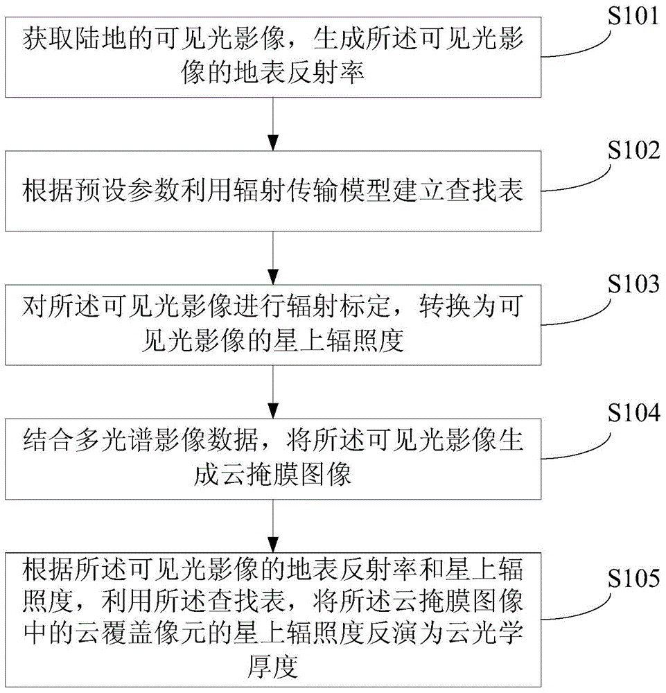
[0050] figure 1 A flow chart of the remote sensing inversion method for the optical depth of land clouds proposed by the present invention, such as figure 1 As shown, the method includes:

[0051]S101. Acquire a visible light image of the land, and generate the surface reflectance of the visible light image; the visible light image is visib...


PUM


Abstract

The invention provides a remote sensing inversion method and system for the land cloud optical thickness. The remote sensing inversion method comprises the steps that visible light images of a land are obtained, and the surface reflectance of the visible light images is generated; a lockup table is established through a radiation transmission module according to preset parameters; radiometric calibration is conducted on the visible light images, and the on-star irradiance of the visible light images is obtained through transformation; cloud mask images are generated through the visible light images with the combination of multi-spectral image data; the on-star irradiance of cloud coverage pixels in the cloud mask images are inverted into the cloud optical thickness through the lockup table according to the surface reflectance and the on-star irradiance of the visible light images. According to the remote sensing inversion method and system for the land cloud optical thickness, the cloud optical thickness at the daytime can be rapidly and accurately extracted based on the extraction precision of the cloud mask images, the method and system are independent from specific sensors and satellites, and good inversion results are obtained under the situation of the high-brightness ground surface with the underlying surfaces such as ice and snow.

Description

technical field [0001] The invention relates to the technical field of atmospheric remote sensing, in particular to a remote sensing inversion method and system for land cloud optical thickness. Background technique [0002] The properties of clouds and their changes on temporal and spatial scales are very important to the study of global climate change. Cloud optical thickness is one of the important parameters to calculate the cloud radiation effect and optical effect, and is the main adjustment parameter of the earth-atmosphere radiation system. Remote sensing technology provides a powerful means for large-scale real-time cloud optical parameter inversion. In the case of large cloud optical thickness, the cloud reflectance function can be written as an expression conforming to the asymptotic theory, where the reflected radiation is a function of cloud optical thickness, ground reflectivity and asymmetry factor in the non-absorbing atmospheric band. When the cloud optica...

Claims


Application Information

Patent Timeline
Patent Type & Authority Applications(China)
IPC IPC(8): G01S7/41G01S17/95G01S17/89
CPCG01S7/4802G01S17/89G01S17/95Y02A90/10
Inventor 张海龙李丽辛晓洲余珊珊
Owner INST OF REMOTE SENSING & DIGITAL EARTH CHINESE ACADEMY OF SCI
Why Eureka
Try Eureka