Method for using remote sensing images to measure sand wave water depth

A remote sensing image and water depth technology, applied in the direction of measuring devices, optical devices, instruments, etc., can solve the problems of unsuitable sand wave water depth measurement, complicated calculation process, and low water depth measurement accuracy

Active Publication Date: 2015-05-13
SECOND INST OF OCEANOGRAPHY MNR
View PDF6 Cites 5 Cited by
  • Summary
  • Abstract
  • Description
  • Claims
  • Application Information

AI Technical Summary

Problems solved by technology

However, limited by the differences in the water environment and bottom conditions, the optical remote sensing bathymetry method is only suitable for clean water and very shallow waters, and basically cannot be used for sand wave bathymetry.
Although SAR and solar flare remote sensing are not affected by the water environment, the existing water depth information extraction method based on the hydrodynamic modulation model needs the support of certain environmental parameters such as water flow field and wind field, the calculation process is complex, and the depth measurement accuracy is very high. lower
From the public information retrieved, there is not yet a method completely consistent with the present invention for utilizing remote sensing images to measure the depth of sand waves in shallow seas

Method used


Image

  • Method for using remote sensing images to measure sand wave water depth
  • Method for using remote sensing images to measure sand wave water depth
  • Method for using remote sensing images to measure sand wave water depth

Examples


Embodiment 1

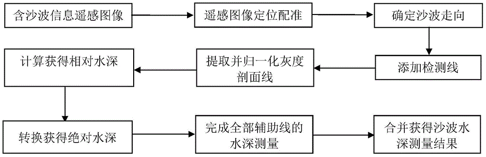
[0044] According to the method of utilizing remote sensing images to measure shallow sea sand wave water depth according to the present invention, the technical route is as follows: figure 1 As shown, it specifically includes the following steps:

[0045] (1) The remote sensing image containing sand wave information is acquired by the remote sensor, and the geometric correction method is used for positioning and registration to realize the registration with the measured terrain data:

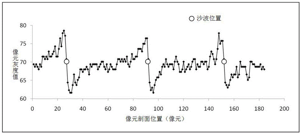
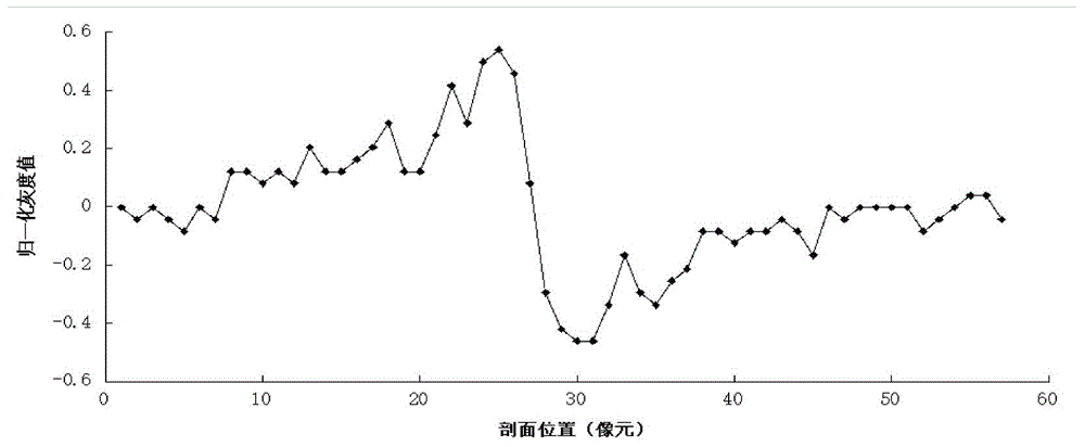
[0046] Select a remote sensing image with a higher resolution to check the clarity and integrity of the sand wave texture information in the image. The space registration of remote sensing images is carried out, and the registration adopts the method of the same name of ground control points, that is, a certain number of the same ground object points are selected in the land area on the remote sensing images, and the control equation is established. The ground control point method avoids the ac...


PUM


Abstract

The invention discloses a new method for using remote sensing images to measure the sand wave water depth of shallow sea. The new method for using the remote sensing images to measure the sand wave water depth of the shallow sea uses the bright-dark stripe feature information of the shallow sea sand wave terrain presented in the remote sensing images and the quantitative relations among the space position thereof, intensity and sand wave water depth to measure the sand wave water depth of the shallow sea. According to the terrain change monitoring requirement for the broadly distributed shallow sea sand wave regions, by means of the large-scale coverage and high-frequency revisit ability of a remote sensing technology method, the gray data of the remote sensing images are quantitatively processed based on the bright-dark stripe features (comprising the strength and space distribution features of the bright and dark stripes) in the remote sensing images generated by the modulation of the sand wave terrain for the water body flow field and sea surface roughness, and moreover, the gray data are converted through a little of measured data to obtain the sand wave water depth information; the new method for using the remote sensing images to measure the sand wave water depth is used for monitoring the dynamic change of the underwater terrain of the shallow sea, is an innovation for using the remote sensing information technology for the shallow sea water depth measurement, and is very high in practical value.

Description

technical field [0001] The invention relates to the field of remote sensing technology application and shallow sea terrain monitoring, in particular to a method for measuring sand wave water depth by using remote sensing images. Background technique [0002] Submarine topographic mapping is the first step in exploring and studying the ocean, the first condition for developing and protecting the ocean, and an urgent need for oceanographic research today. It is of great significance for mastering the laws and characteristics of terrain evolution. Before the invention of the echo sounder, the water depth was mainly measured by the sounding rod and the sounding hammer, and the measurement accuracy was poor. After the echo sounder appeared in the 1920s, the drawing of sea charts in the modern sense was realized. However, the early echo sounders were launched with a single beam, and one launch could only obtain the water depth directly below the survey ship, so it could only achi...

Claims


Application Information

Patent Timeline
Patent Type & Authority Applications(China)
IPC IPC(8): G01B11/22
Inventor 张华国傅斌厉冬玲史爱琴楼琇林
Owner SECOND INST OF OCEANOGRAPHY MNR
Why Eureka
Try Eureka