
BD, GPS and MEMS based integrated navigation system and method

An integrated navigation system and integrated navigation technology, applied to GPS and MEMS integrated navigation systems, based on the BD field, can solve the problems of inability to realize navigation alone, low precision of MEMS-IMU, etc., to reduce volume and power consumption, and reduce system volume and power consumption, cost reduction effect

Active Publication Date: 2015-06-10
CHINA ELECTRONIC TECH GRP CORP NO 38 RES INST
View PDF4 Cites 26 Cited by
  • Summary
  • Abstract
  • Description
  • Claims
  • Application Information

AI Technical Summary

Problems solved by technology

However, at present, the accuracy of MEMS-IMU is still at a low level, and it is impossible to realize navigation alone. Further hardware structure design and optimization of navigation algorithms are needed to meet the needs of technological development.

Method used


Image

  • BD, GPS and MEMS based integrated navigation system and method
  • BD, GPS and MEMS based integrated navigation system and method
  • BD, GPS and MEMS based integrated navigation system and method

Examples


Embodiment Construction

[0028] The technical details of the present invention will now be described in detail in conjunction with the accompanying drawings.

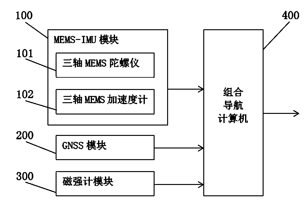
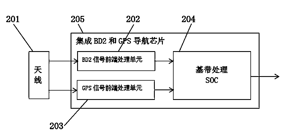
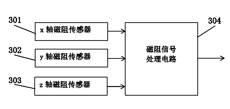
[0029] see figure 1 , an integrated navigation system based on BD, GPS and MEMS, installed on a carrier, including a MEMS-IMU module 100 , a GNSS module 200 , a magnetometer module 300 and an integrated navigation computer 400 . The MEMS-IMU module 100 , the GNSS module 200 and the magnetometer module 300 are respectively connected to the integrated navigation computer 400 .

[0030] The MEMS-IMU module 100 includes a three-axis MEMS gyroscope 101 and a three-axis MEMS accelerometer 102 , wherein the three-axis MEMS gyroscope 101 is a single-chip digital angular velocity detector responsible for outputting angular velocity signals to the integrated navigation computer 400 . The three-axis MEMS accelerometer 102 is a single-chip digital specific force detector, which is responsible for outputting a specific force signal to the integrated naviga...


PUM


Abstract

The invention provides a BD, GPS and MEMS based integrated navigation system and method on account of defects f prior navigation systems. The system comprises an MEMS-IMU module, a GNSS module, a magnetometer module and an integrated navigation computer. The MEMS-IMU module, THE GNSS module and the magnetometer module are connected with the integrated navigation system respectively. By the aid of the navigation method, corrected position values, speed values and corrected attitude angle values can be output. The system and the method have the advantages of being anti-overloading, miniaturized, low in power consumption and cost, provided with high impact resistance and particularly applicable to various war environments. By the aid of the navigation method, drifting of gyroscopes, accelerometer and magnetometers can be suppressed, and the stability and the accuracy of the system are improved.

Description

technical field [0001] The invention belongs to the field of navigation technology, is applicable to the field of systems such as micro-platform stability control, attitude and course reference, integrated navigation, and is specifically an integrated navigation system and navigation method based on BD, GPS and MEMS. Background technique [0002] With the continuous advancement of new military reform ideas and the continuous upgrading of domestic weapons and equipment, a series of new requirements have been put forward for the precision strike of weapon systems in the field of national defense: anti-overload, miniaturization, low power consumption, low cost, and high precision. However, the existing integrated navigation systems generally have shortcomings such as large volume, difficulty in integration, and poor accuracy. However, the performance of the inertial microsensor (MEMS-IMU) developed in recent years and using integrated circuit processing technology has been cont...

Claims


Application Information

Patent Timeline
Patent Type & Authority Applications(China)
IPC IPC(8): G01S19/47
CPCG01S19/47
Inventor 王佩生朱家兵郭二辉
Owner CHINA ELECTRONIC TECH GRP CORP NO 38 RES INST
Learn More