Remote sensing image fusion method based on multi-dimensional morphologic element analysis

A morphological component analysis, remote sensing image fusion technology, applied in image enhancement, image data processing, instruments, etc., can solve the problem that large remote sensing images are difficult to put into practical application, wavelet transform analysis method multi-man-made noise, remote sensing image analysis and decomposition are unfavorable, etc. question

Active Publication Date: 2015-06-10
YANTAI UNIV
View PDF3 Cites 15 Cited by
  • Summary
  • Abstract
  • Description
  • Claims
  • Application Information

AI Technical Summary

Problems solved by technology

At present, the problems of remote sensing images are as follows: ① A single remote sensing image often only contains part of the ground features, but cannot reflect all the content; ② Compared with single-source data, multi-source data are complementary, and there is a certain amount of Redundancy; ③ Due to the large amount of information and high redundancy of multi-source remote sensing data, its utilization rate is low
[0004] 1) The fusion results of IHS transformation method, Brovey method and principal component analysis method have large spectral distortion, and the spatial resolution has a large room for improvement; (refer to comparison file 1, comparison file 2, and comparison file 3)
[0005] 2) The wavelet transform analysis method will introduce more artificial noise, and there is a large spectral distortion; (refer to comparative document 4)
[0006] 3) The sparse reconstruction method based on base tracking and matching tracking has a huge amount of calculation, and small images are often used in simulation experiments for testing, and it is difficult to put real large remote sensing images into practical application
However, the existing morphological component analysis method is carried out at a single scale, which is unfavorable for the analysis and decomposition of remote sensing images with complex surface features

Method used


Image

  • Remote sensing image fusion method based on multi-dimensional morphologic element analysis
  • Remote sensing image fusion method based on multi-dimensional morphologic element analysis
  • Remote sensing image fusion method based on multi-dimensional morphologic element analysis

Examples


Embodiment Construction

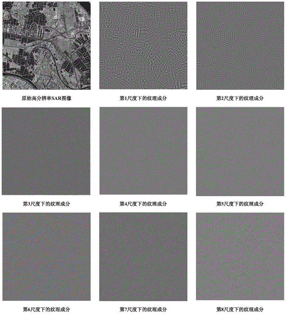
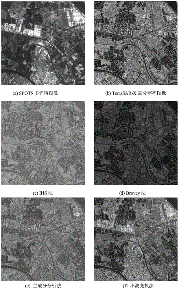
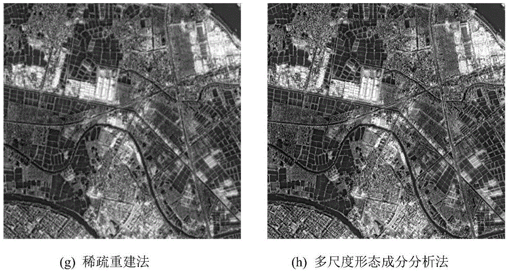
[0022] The curvelet transform base can effectively capture the cartoon component of the image, and the local discrete cosine transform base can effectively capture the texture component of the image. Therefore, the joint curvelet transform basis Φ 1 and local discrete cosine transform basis Φ 2 Decomposition dictionary Φ=[Φ as morphological component analysis 1 ,Φ 2 ], and perform multi-scale morphological component decomposition on high-resolution remote sensing images and multispectral remote sensing images, respectively. Abandon the noise-containing scale part of the high-resolution remote sensing image, and retain the texture components decomposed by other scales; discard the texture components of the multispectral image, and retain the cartoon (segment smoothing) component of the multispectral image under TV constraints. The texture components of the retained high-resolution remote sensing images and the segmented smooth components of the multispectral images are used ...


PUM


Abstract

The invention discloses a remote sensing image fusion method based on multi-dimensional morphologic element analysis, and belongs to the field of crossing signal processing and remote sensing image processing. The method is that the morphologic element analysis is respectively carried out for a high-resolution remote sensing image and a multi-spectrum remote sensing image under different dimension; the iterative shrinkage method is carried out to perform sparse decomposition; a target image to be fused is divided into texture components and cartoon components based on a plurality of dimensions; the cartoon component and the noise component in the high-solution image, and the texture component and the noise components in the multi-spectrum image are removed; the effective dimension texture component in the high-solution image and the cartoon component in the multi-spectrum image are remained and subjected to spare reconstruction, so as to obtain the fusion image. With the adoption of the method, the high-resolution remote sensing image and the multi-spectrum remote sensing image are effectively fused; the space resolution is improved and the spectrum distortion is reduced by being compared with the existing fusion method; in addition, the rate is greatly increased by being compared with the existing sparse reconstruction method.

Description

Technical field: [0001] The invention belongs to the intersection field of signal analysis and remote sensing image processing, and is a remote sensing image fusion method based on multi-scale morphological component analysis. Background technique: [0002] With the rapid development of computer technology, aerospace technology, and remote sensing technology, image resource acquisition methods (multi-sensor, multi-platform) are increasingly abundant, and the obtained remote sensing images also present the characteristics of multi-spatial resolution, multi-spectrum, and multi-temporal equality. At present, the problems of remote sensing images are as follows: ① A single remote sensing image often only contains part of the ground features, but cannot reflect all the content; ② Compared with single-source data, multi-source data are complementary, and there is a certain amount of Redundancy; ③ Due to the large amount of information and high redundancy of multi-source remote sen...

Claims


Application Information

Patent Timeline
Patent Type & Authority Applications(China)
IPC IPC(8): G06T5/50
Inventor 徐金东倪梦莹
Owner YANTAI UNIV
Why Eureka
Try Eureka